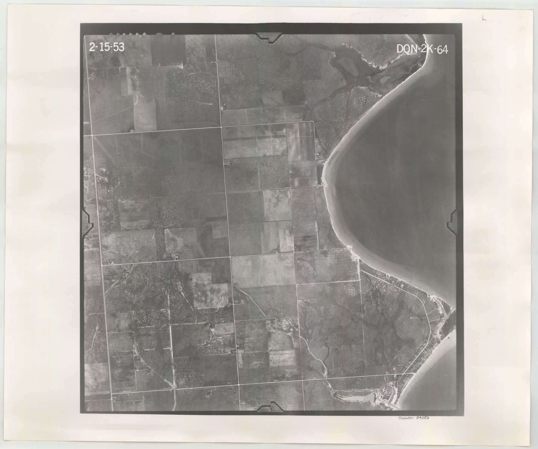
Flight Mission No. DQN-2K, Frame 64, Calhoun County
DQN-2K-64
-
Map/Doc
84256
-
Collection
General Map Collection
-
Object Dates
1953/2/15 (Creation Date)
-
People and Organizations
U. S. Department of Agriculture (Publisher)
-
Counties
Calhoun
-
Subjects
Aerial Photograph
-
Height x Width
18.6 x 22.3 inches
47.2 x 56.6 cm
-
Comments
Flown by Aero Exploration Company of Tulsa, Oklahoma.
Part of: General Map Collection
Webb County Working Sketch 44

Print $20.00
- Digital $50.00
Webb County Working Sketch 44
1943
Size 26.0 x 27.4 inches
Map/Doc 72409
Upper Galveston Bay, Houston Ship Channel, Dollar Pt. to Atkinson I.

Print $40.00
- Digital $50.00
Upper Galveston Bay, Houston Ship Channel, Dollar Pt. to Atkinson I.
1978
Size 49.3 x 36.8 inches
Map/Doc 69898
Tyler County Rolled Sketch 10

Print $40.00
- Digital $50.00
Tyler County Rolled Sketch 10
1982
Size 48.7 x 35.4 inches
Map/Doc 10032
Flight Mission No. CRK-3P, Frame 125, Refugio County

Print $20.00
- Digital $50.00
Flight Mission No. CRK-3P, Frame 125, Refugio County
1956
Size 18.5 x 22.5 inches
Map/Doc 86913
Madison County Working Sketch 4

Print $20.00
- Digital $50.00
Madison County Working Sketch 4
1973
Size 12.7 x 12.9 inches
Map/Doc 70766
Hamilton County Working Sketch 30

Print $20.00
- Digital $50.00
Hamilton County Working Sketch 30
1982
Size 24.7 x 24.7 inches
Map/Doc 63368
Lee County Sketch File 5

Print $40.00
- Digital $50.00
Lee County Sketch File 5
Size 12.2 x 15.8 inches
Map/Doc 29686
Travis County State Real Property Sketch 18

Print $20.00
Travis County State Real Property Sketch 18
2005
Size 24.4 x 35.2 inches
Map/Doc 96976
Erath County Sketch File 8

Print $4.00
- Digital $50.00
Erath County Sketch File 8
Size 8.6 x 13.0 inches
Map/Doc 22269
Brazoria County Rolled Sketch 37

Print $20.00
- Digital $50.00
Brazoria County Rolled Sketch 37
Size 18.5 x 25.0 inches
Map/Doc 5173
Pecos County Sketch File 95

Print $6.00
- Digital $50.00
Pecos County Sketch File 95
1956
Size 11.2 x 8.8 inches
Map/Doc 33995
Williamson County Sketch File 12

Print $4.00
- Digital $50.00
Williamson County Sketch File 12
1860
Size 12.6 x 3.4 inches
Map/Doc 40326
You may also like
Brazoria County NRC Article 33.136 Sketch 11

Print $24.00
- Digital $50.00
Brazoria County NRC Article 33.136 Sketch 11
2012
Size 24.0 x 18.0 inches
Map/Doc 94777
Flight Mission No. DIX-10P, Frame 168, Aransas County

Print $20.00
- Digital $50.00
Flight Mission No. DIX-10P, Frame 168, Aransas County
1956
Size 18.7 x 22.3 inches
Map/Doc 83958
Trinity River, Bazzette Sheet

Print $4.00
- Digital $50.00
Trinity River, Bazzette Sheet
1925
Size 28.2 x 24.9 inches
Map/Doc 65218
Flight Mission No. DQO-8K, Frame 8, Galveston County

Print $20.00
- Digital $50.00
Flight Mission No. DQO-8K, Frame 8, Galveston County
1952
Size 18.8 x 22.5 inches
Map/Doc 85131
Reference Book of Burnet's, [Vehlein's] & Zavala's Colonies
![94554, Reference Book of Burnet's, [Vehlein's] & Zavala's Colonies, Historical Volumes](https://historictexasmaps.com/wmedia_w700/pdf_converted_jpg/qi_pdf_thumbnail_39143.jpg)
Reference Book of Burnet's, [Vehlein's] & Zavala's Colonies
Map/Doc 94554
General Highway Map, Karnes County, Texas

Print $20.00
General Highway Map, Karnes County, Texas
1940
Size 18.3 x 24.7 inches
Map/Doc 79151
Colorado County Working Sketch 25

Print $20.00
- Digital $50.00
Colorado County Working Sketch 25
1972
Size 39.1 x 34.2 inches
Map/Doc 68125
Panola County Working Sketch 20

Print $20.00
- Digital $50.00
Panola County Working Sketch 20
1945
Map/Doc 71429
Roberts County Working Sketch 4

Print $20.00
- Digital $50.00
Roberts County Working Sketch 4
1945
Size 37.1 x 32.8 inches
Map/Doc 63530
Wichita County Working Sketch 8

Print $20.00
- Digital $50.00
Wichita County Working Sketch 8
1919
Size 18.3 x 37.7 inches
Map/Doc 72517
Corpus Christi, Where Texas Meets the Sea

Corpus Christi, Where Texas Meets the Sea
1927
Size 9.6 x 4.3 inches
Map/Doc 97064
Intracoastal Waterway in Texas - Corpus Christi to Point Isabel including Arroyo Colorado to Mo. Pac. R.R. Bridge Near Harlingen

Print $20.00
- Digital $50.00
Intracoastal Waterway in Texas - Corpus Christi to Point Isabel including Arroyo Colorado to Mo. Pac. R.R. Bridge Near Harlingen
1933
Size 28.1 x 41.2 inches
Map/Doc 61845