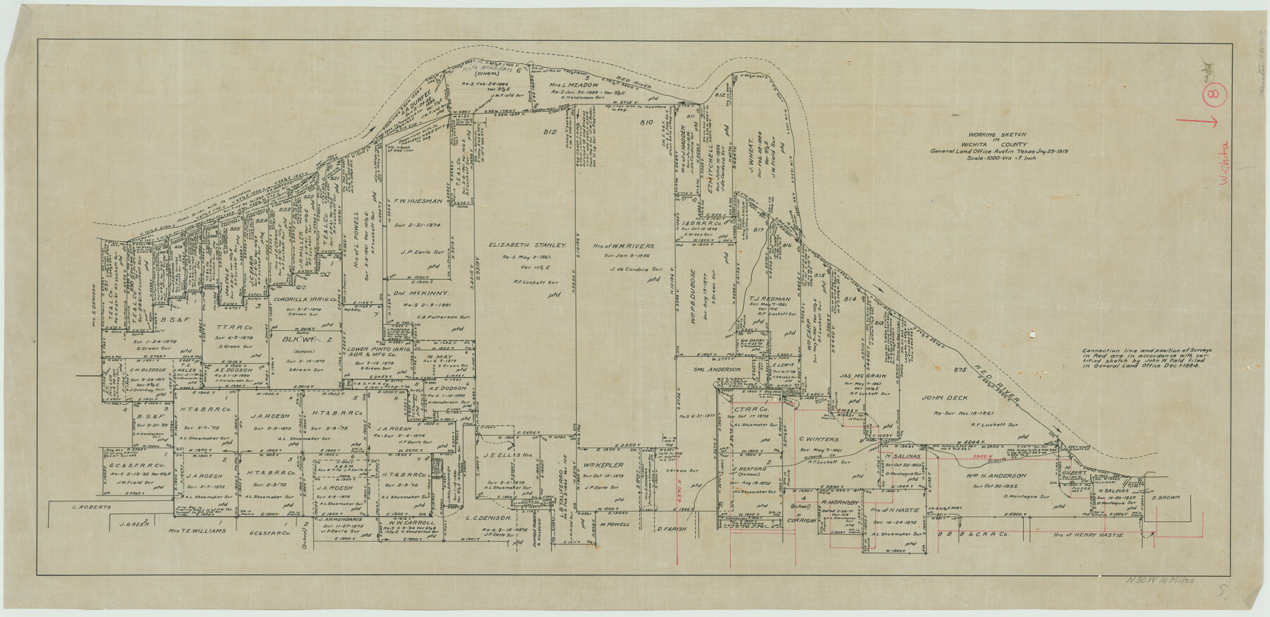
Wichita County Working Sketch 8
-
Map/Doc
72517
-
Collection
General Map Collection
-
Object Dates
1/23/1919 (Creation Date)
-
Counties
Wichita
-
Subjects
Surveying Working Sketch
-
Height x Width
18.3 x 37.7 inches
46.5 x 95.8 cm
-
Scale
1" = 1000 varas
Part of: General Map Collection
Kinney County Boundary File 1b

Print $8.00
- Digital $50.00
Kinney County Boundary File 1b
Size 14.3 x 8.7 inches
Map/Doc 64955
Runnels County Rolled Sketch 46

Print $20.00
- Digital $50.00
Runnels County Rolled Sketch 46
1954
Size 33.5 x 39.0 inches
Map/Doc 9872
Flight Mission No. DCL-6C, Frame 128, Kenedy County

Print $20.00
- Digital $50.00
Flight Mission No. DCL-6C, Frame 128, Kenedy County
1943
Size 18.6 x 22.3 inches
Map/Doc 85958
Flight Mission No. BRE-5P, Frame 199, Nueces County

Print $20.00
- Digital $50.00
Flight Mission No. BRE-5P, Frame 199, Nueces County
1956
Size 18.4 x 22.3 inches
Map/Doc 86839
Liberty County Sketch File 16

Print $4.00
- Digital $50.00
Liberty County Sketch File 16
1859
Size 11.4 x 6.7 inches
Map/Doc 29917
Controlled Mosaic by Jack Amman Photogrammetric Engineers, Inc - Sheet 21

Print $20.00
- Digital $50.00
Controlled Mosaic by Jack Amman Photogrammetric Engineers, Inc - Sheet 21
1954
Size 20.0 x 24.0 inches
Map/Doc 83470
Sutton County Sketch File 47

Print $4.00
- Digital $50.00
Sutton County Sketch File 47
1939
Size 11.4 x 8.8 inches
Map/Doc 37519
Starr County Working Sketch 2

Print $20.00
- Digital $50.00
Starr County Working Sketch 2
1916
Size 12.0 x 37.0 inches
Map/Doc 63918
Brewster County Rolled Sketch 71

Print $20.00
- Digital $50.00
Brewster County Rolled Sketch 71
1940
Size 29.9 x 42.9 inches
Map/Doc 8491
Cherokee County Working Sketch 1

Print $20.00
- Digital $50.00
Cherokee County Working Sketch 1
1925
Size 22.9 x 24.1 inches
Map/Doc 67956
Garza County Rolled Sketch 17

Print $20.00
- Digital $50.00
Garza County Rolled Sketch 17
1959
Size 32.3 x 37.6 inches
Map/Doc 6003
Edwards County Working Sketch Graphic Index - east part - sheet 2

Print $40.00
- Digital $50.00
Edwards County Working Sketch Graphic Index - east part - sheet 2
1975
Size 54.7 x 39.8 inches
Map/Doc 76534
You may also like
Panola County Working Sketch 21

Print $20.00
- Digital $50.00
Panola County Working Sketch 21
1947
Map/Doc 71430
G. C. & S. F., Main Line, Texas, Right of Way map, Rio Vista to Crowley

Print $40.00
- Digital $50.00
G. C. & S. F., Main Line, Texas, Right of Way map, Rio Vista to Crowley
1910
Size 38.1 x 122.4 inches
Map/Doc 64653
[Township 5-S, Blocks 36, 37 & 38]
![92291, [Township 5-S, Blocks 36, 37 & 38], Twichell Survey Records](https://historictexasmaps.com/wmedia_w700/maps/92291-1.tif.jpg)
Print $20.00
- Digital $50.00
[Township 5-S, Blocks 36, 37 & 38]
1952
Size 27.6 x 26.5 inches
Map/Doc 92291
Flight Mission No. DAG-21K, Frame 127, Matagorda County

Print $20.00
- Digital $50.00
Flight Mission No. DAG-21K, Frame 127, Matagorda County
1952
Size 18.5 x 22.4 inches
Map/Doc 86453
Map of South America engraved to illustrate Mitchell's school and family geography

Print $20.00
- Digital $50.00
Map of South America engraved to illustrate Mitchell's school and family geography
1839
Size 11.8 x 9.5 inches
Map/Doc 93501
Flight Mission No. DQN-4K, Frame 4, Calhoun County

Print $20.00
- Digital $50.00
Flight Mission No. DQN-4K, Frame 4, Calhoun County
1953
Size 18.8 x 22.3 inches
Map/Doc 84369
[Map showing J. H. Gibson Block D]
![92016, [Map showing J. H. Gibson Block D], Twichell Survey Records](https://historictexasmaps.com/wmedia_w700/maps/92016-1.tif.jpg)
Print $20.00
- Digital $50.00
[Map showing J. H. Gibson Block D]
Size 17.8 x 15.1 inches
Map/Doc 92016
Right of Way and Track Map, The Wichita Falls & Southern Railway

Print $40.00
- Digital $50.00
Right of Way and Track Map, The Wichita Falls & Southern Railway
1942
Size 25.0 x 121.0 inches
Map/Doc 64512
Brazoria County Sketch File 10a

Print $50.00
- Digital $50.00
Brazoria County Sketch File 10a
1912
Size 7.1 x 8.7 inches
Map/Doc 14940
Ochiltree County State of Texas

Print $20.00
- Digital $50.00
Ochiltree County State of Texas
1889
Size 25.5 x 19.0 inches
Map/Doc 4609
Subdivisions of Hall County School Land situated in Bailey and Cockran (sic) Counties, Texas owned by G. T. Oliver, Amarillo, Tex.

Print $2.00
- Digital $50.00
Subdivisions of Hall County School Land situated in Bailey and Cockran (sic) Counties, Texas owned by G. T. Oliver, Amarillo, Tex.
1907
Size 8.2 x 15.7 inches
Map/Doc 90477
