Brazoria County Sketch File 10a
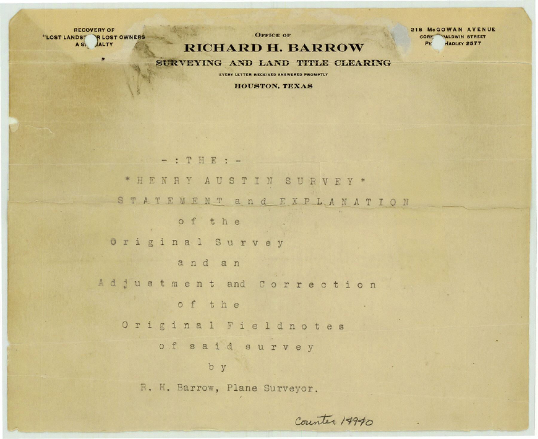
[Statement and explanation of the Henry Austin original survey and an adjustment and correction of the original field notes of said survey]
-
Map/Doc
14940
-
Collection
General Map Collection
-
Object Dates
1912/2/12 (Creation Date)
1912/3/7 (File Date)
-
People and Organizations
R.H. Barrow (Surveyor/Engineer)
E.S. Atkinson, Jr. (Surveyor/Engineer)
-
Counties
Brazoria
-
Subjects
Surveying Sketch File
-
Height x Width
7.1 x 8.7 inches
18.0 x 22.1 cm
-
Medium
multi-page, multi-format
-
Features
Bastrop Lake
Oyster Lake
Bastrop Bay
Galveston Island
Christmas Point
Cox's Lake
Part of: General Map Collection
Johnson County
![3732, Johnson County, General Map Collection](https://historictexasmaps.com/wmedia_w700/maps/3732-1.tif.jpg)
Print $20.00
- Digital $50.00
Johnson County
1859
Size 22.0 x 29.6 inches
Map/Doc 3732
Brewster County Working Sketch 105
![67705, Brewster County Working Sketch 105, General Map Collection](https://historictexasmaps.com/wmedia_w700/maps/67705.tif.jpg)
Print $40.00
- Digital $50.00
Brewster County Working Sketch 105
Size 42.5 x 77.6 inches
Map/Doc 67705
Fractional Township No. 8 South Range No. 16 East of the Indian Meridian, Indian Territory
![75228, Fractional Township No. 8 South Range No. 16 East of the Indian Meridian, Indian Territory, General Map Collection](https://historictexasmaps.com/wmedia_w700/maps/75228.tif.jpg)
Print $20.00
- Digital $50.00
Fractional Township No. 8 South Range No. 16 East of the Indian Meridian, Indian Territory
1896
Size 19.3 x 24.3 inches
Map/Doc 75228
Coke County Working Sketch 5
![68042, Coke County Working Sketch 5, General Map Collection](https://historictexasmaps.com/wmedia_w700/maps/68042-1.tif.jpg)
Print $20.00
- Digital $50.00
Coke County Working Sketch 5
Size 24.1 x 27.9 inches
Map/Doc 68042
Flight Mission No. DAG-17K, Frame 62, Matagorda County
![86324, Flight Mission No. DAG-17K, Frame 62, Matagorda County, General Map Collection](https://historictexasmaps.com/wmedia_w700/pdf_converted_jpg/qi_pdf_thumbnail_33468.jpg)
Print $20.00
- Digital $50.00
Flight Mission No. DAG-17K, Frame 62, Matagorda County
1952
Size 16.4 x 16.4 inches
Map/Doc 86324
Montgomery County Working Sketch 72
![71179, Montgomery County Working Sketch 72, General Map Collection](https://historictexasmaps.com/wmedia_w700/maps/71179.tif.jpg)
Print $6.00
- Digital $50.00
Montgomery County Working Sketch 72
Size 17.2 x 32.4 inches
Map/Doc 71179
Dawson County Sketch File 9
![20542, Dawson County Sketch File 9, General Map Collection](https://historictexasmaps.com/wmedia_w700/pdf_converted_jpg/qi_pdf_thumbnail_10634.jpg)
Print $4.00
- Digital $50.00
Dawson County Sketch File 9
1925
Size 11.3 x 8.7 inches
Map/Doc 20542
Johnson County Sketch File 25
![28459, Johnson County Sketch File 25, General Map Collection](https://historictexasmaps.com/wmedia_w700/pdf_converted_jpg/qi_pdf_thumbnail_12336.jpg)
Print $50.00
- Digital $50.00
Johnson County Sketch File 25
Size 13.9 x 8.3 inches
Map/Doc 28459
Sketch E Showing the Progress of the Survey of Section V From 1847 to 1852
![97213, Sketch E Showing the Progress of the Survey of Section V From 1847 to 1852, General Map Collection](https://historictexasmaps.com/wmedia_w700/maps/97213.tif.jpg)
Print $20.00
- Digital $50.00
Sketch E Showing the Progress of the Survey of Section V From 1847 to 1852
1852
Size 12.4 x 22.7 inches
Map/Doc 97213
Andrews County Rolled Sketch 15
![77166, Andrews County Rolled Sketch 15, General Map Collection](https://historictexasmaps.com/wmedia_w700/maps/77166.tif.jpg)
Print $20.00
- Digital $50.00
Andrews County Rolled Sketch 15
1934
Size 27.9 x 22.4 inches
Map/Doc 77166
Flight Mission No. DQN-6K, Frame 16, Calhoun County
![84438, Flight Mission No. DQN-6K, Frame 16, Calhoun County, General Map Collection](https://historictexasmaps.com/wmedia_w700/pdf_converted_jpg/qi_pdf_thumbnail_31655.jpg)
Print $20.00
- Digital $50.00
Flight Mission No. DQN-6K, Frame 16, Calhoun County
1953
Size 18.7 x 22.2 inches
Map/Doc 84438
Nacogdoches County Boundary File 1a
![57581, Nacogdoches County Boundary File 1a, General Map Collection](https://historictexasmaps.com/wmedia_w700/pdf_converted_jpg/qi_pdf_thumbnail_16614.jpg)
Print $20.00
- Digital $50.00
Nacogdoches County Boundary File 1a
Size 4.7 x 30.5 inches
Map/Doc 57581
You may also like
Culberson County Working Sketch 16
![68468, Culberson County Working Sketch 16, General Map Collection](https://historictexasmaps.com/wmedia_w700/maps/68468.tif.jpg)
Print $20.00
- Digital $50.00
Culberson County Working Sketch 16
Size 17.5 x 23.4 inches
Map/Doc 68468
Working Sketch in Dickens & King Cos.
![10770, Working Sketch in Dickens & King Cos., Maddox Collection](https://historictexasmaps.com/wmedia_w700/maps/10770.tif.jpg)
Print $20.00
- Digital $50.00
Working Sketch in Dickens & King Cos.
Size 24.4 x 20.4 inches
Map/Doc 10770
Polk County Sketch File 28
![34198, Polk County Sketch File 28, General Map Collection](https://historictexasmaps.com/wmedia_w700/pdf_converted_jpg/qi_pdf_thumbnail_13655.jpg)
Print $4.00
- Digital $50.00
Polk County Sketch File 28
Size 8.6 x 9.9 inches
Map/Doc 34198
[Santa Rosa Leagues, Brooks & Kenedy Counties, Texas]
![10774, [Santa Rosa Leagues, Brooks & Kenedy Counties, Texas], Maddox Collection](https://historictexasmaps.com/wmedia_w700/maps/10774.tif.jpg)
Print $20.00
- Digital $50.00
[Santa Rosa Leagues, Brooks & Kenedy Counties, Texas]
Size 21.0 x 24.6 inches
Map/Doc 10774
[Sketch for Mineral Application 27670 - Strip between Simon Sanchez leagues and Trinity River]
![2865, [Sketch for Mineral Application 27670 - Strip between Simon Sanchez leagues and Trinity River], General Map Collection](https://historictexasmaps.com/wmedia_w700/maps/2865.tif.jpg)
Print $40.00
- Digital $50.00
[Sketch for Mineral Application 27670 - Strip between Simon Sanchez leagues and Trinity River]
1934
Size 17.3 x 50.5 inches
Map/Doc 2865
Ward County Boundary File 3a
![59684, Ward County Boundary File 3a, General Map Collection](https://historictexasmaps.com/wmedia_w700/pdf_converted_jpg/qi_pdf_thumbnail_16918.jpg)
Print $22.00
- Digital $50.00
Ward County Boundary File 3a
Size 13.1 x 8.6 inches
Map/Doc 59684
Harris County Working Sketch 13
![65905, Harris County Working Sketch 13, General Map Collection](https://historictexasmaps.com/wmedia_w700/maps/65905.tif.jpg)
Print $20.00
- Digital $50.00
Harris County Working Sketch 13
Size 19.9 x 11.0 inches
Map/Doc 65905
Clay County Rolled Sketch 4
![5486, Clay County Rolled Sketch 4, General Map Collection](https://historictexasmaps.com/wmedia_w700/maps/5486.tif.jpg)
Print $20.00
- Digital $50.00
Clay County Rolled Sketch 4
1949
Size 32.2 x 25.6 inches
Map/Doc 5486
Grayson County Sketch File 4
![24462, Grayson County Sketch File 4, General Map Collection](https://historictexasmaps.com/wmedia_w700/pdf_converted_jpg/qi_pdf_thumbnail_11457.jpg)
Print $4.00
- Digital $50.00
Grayson County Sketch File 4
1856
Size 12.5 x 8.2 inches
Map/Doc 24462
Right of Way and Track Map, The Missouri, Kansas and Texas Ry. of Texas operated by the Missouri, Kansas and Texas Ry. of Texas, Henrietta Division
![64072, Right of Way and Track Map, The Missouri, Kansas and Texas Ry. of Texas operated by the Missouri, Kansas and Texas Ry. of Texas, Henrietta Division, General Map Collection](https://historictexasmaps.com/wmedia_w700/maps/64072.tif.jpg)
Print $40.00
- Digital $50.00
Right of Way and Track Map, The Missouri, Kansas and Texas Ry. of Texas operated by the Missouri, Kansas and Texas Ry. of Texas, Henrietta Division
1918
Size 25.1 x 56.7 inches
Map/Doc 64072
Flight Mission No. CRC-4R, Frame 110, Chambers County
![84907, Flight Mission No. CRC-4R, Frame 110, Chambers County, General Map Collection](https://historictexasmaps.com/wmedia_w700/pdf_converted_jpg/qi_pdf_thumbnail_32120.jpg)
Print $20.00
- Digital $50.00
Flight Mission No. CRC-4R, Frame 110, Chambers County
1956
Size 18.6 x 22.3 inches
Map/Doc 84907
Map Showing North and West Boundaries of Gray County, Texas
![89942, Map Showing North and West Boundaries of Gray County, Texas, Twichell Survey Records](https://historictexasmaps.com/wmedia_w700/maps/89942-1.tif.jpg)
Print $20.00
- Digital $50.00
Map Showing North and West Boundaries of Gray County, Texas
1906
Size 42.4 x 38.9 inches
Map/Doc 89942