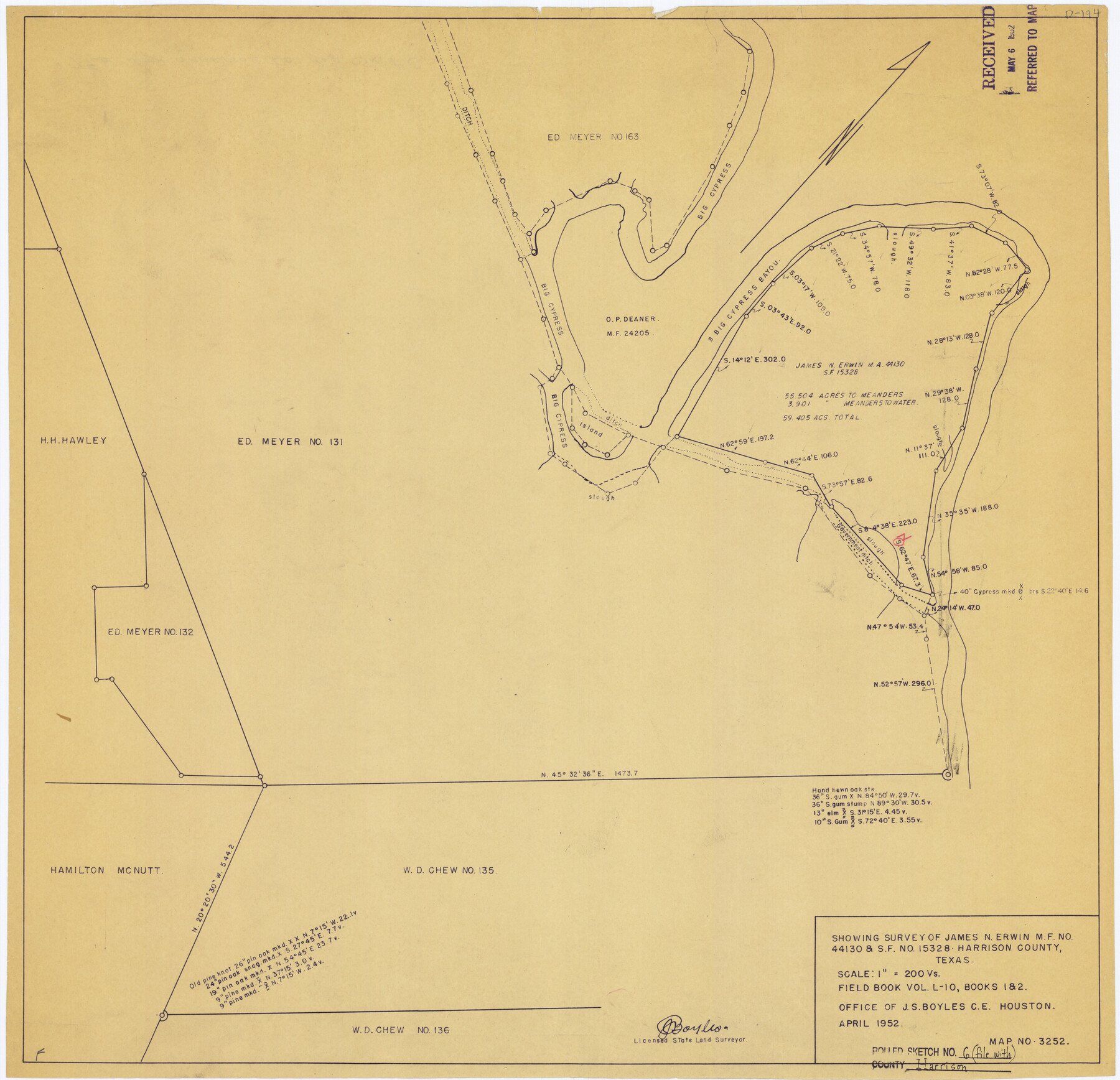
Harrison County Rolled Sketch 6
[Sketch] Showing surveys of James N. Erwin MF No. 44130 & SF No. 15328, Harrison County, Texas
-
Map/Doc
6152
-
Collection
General Map Collection
-
Object Dates
1952 (Creation Date)
1952/5/6 (File Date)
-
People and Organizations
J.S. Boyles (Surveyor/Engineer)
-
Counties
Harrison
-
Subjects
Surveying Rolled Sketch
-
Height x Width
23.4 x 24.2 inches
59.4 x 61.5 cm
-
Medium
van dyke/brownline/sepia
-
Scale
1" = 200 varas
Part of: General Map Collection
Cooke County Working Sketch 14

Print $40.00
- Digital $50.00
Cooke County Working Sketch 14
1944
Size 34.1 x 49.7 inches
Map/Doc 68251
Colorado River, Wharton Sheet

Print $6.00
- Digital $50.00
Colorado River, Wharton Sheet
1941
Size 27.3 x 35.7 inches
Map/Doc 65314
Montgomery County Sketch File 34

Print $8.00
- Digital $50.00
Montgomery County Sketch File 34
1949
Size 14.4 x 8.7 inches
Map/Doc 31904
Donley County Sketch File 21

Print $4.00
- Digital $50.00
Donley County Sketch File 21
Size 8.4 x 9.5 inches
Map/Doc 21256
Fisher County Boundary File 3

Print $32.00
- Digital $50.00
Fisher County Boundary File 3
Size 8.2 x 4.2 inches
Map/Doc 53428
Potter County Sketch File 16

Print $38.00
- Digital $50.00
Potter County Sketch File 16
Size 13.0 x 13.9 inches
Map/Doc 34401
Map of Castro County

Print $20.00
- Digital $50.00
Map of Castro County
1900
Size 41.9 x 34.4 inches
Map/Doc 4748
Smith County Sketch File 5

Print $6.00
- Digital $50.00
Smith County Sketch File 5
1857
Size 8.4 x 7.8 inches
Map/Doc 36754
Flight Mission No. CUG-3P, Frame 138, Kleberg County

Print $20.00
- Digital $50.00
Flight Mission No. CUG-3P, Frame 138, Kleberg County
1956
Size 18.6 x 22.4 inches
Map/Doc 86273
Hamilton County Sketch File 13

Print $40.00
- Digital $50.00
Hamilton County Sketch File 13
1876
Size 12.0 x 16.7 inches
Map/Doc 24935

Brown County Sketch File 30

Print $27.00
- Digital $50.00
Brown County Sketch File 30
1924
Size 12.7 x 11.0 inches
Map/Doc 16631
You may also like
Glasscock County Working Sketch 10

Print $40.00
- Digital $50.00
Glasscock County Working Sketch 10
1957
Size 77.9 x 37.2 inches
Map/Doc 63183
General Highway Map. Detail of Cities and Towns in Austin County, Texas [Sealy and Bellville, etc.]
![79358, General Highway Map. Detail of Cities and Towns in Austin County, Texas [Sealy and Bellville, etc.], Texas State Library and Archives](https://historictexasmaps.com/wmedia_w700/maps/79358.tif.jpg)
Print $20.00
General Highway Map. Detail of Cities and Towns in Austin County, Texas [Sealy and Bellville, etc.]
1961
Size 18.2 x 25.0 inches
Map/Doc 79358
San Jacinto County Rolled Sketch 3

Print $40.00
- Digital $50.00
San Jacinto County Rolled Sketch 3
Size 24.4 x 59.4 inches
Map/Doc 9880
Land grants from the state of Tamaulipas in the trans-Nueces

Land grants from the state of Tamaulipas in the trans-Nueces
2009
Size 11.0 x 8.5 inches
Map/Doc 94040
Chambers County Working Sketch 9

Print $20.00
- Digital $50.00
Chambers County Working Sketch 9
1946
Size 43.9 x 29.8 inches
Map/Doc 67992
Jeff Davis County Rolled Sketch 33

Print $20.00
- Digital $50.00
Jeff Davis County Rolled Sketch 33
1986
Size 39.8 x 30.6 inches
Map/Doc 6379
Coast of Texas from head of East Bay Galveston Harbor to Sabine Pass

Print $40.00
- Digital $50.00
Coast of Texas from head of East Bay Galveston Harbor to Sabine Pass
1882
Size 32.6 x 54.1 inches
Map/Doc 69838
Flight Mission No. CUG-1P, Frame 159, Kleberg County

Print $20.00
- Digital $50.00
Flight Mission No. CUG-1P, Frame 159, Kleberg County
1956
Size 18.5 x 22.3 inches
Map/Doc 86166
Cass County Working Sketch 1

Print $20.00
- Digital $50.00
Cass County Working Sketch 1
Size 20.2 x 21.9 inches
Map/Doc 67904
Uvalde County Working Sketch 62

Print $20.00
- Digital $50.00
Uvalde County Working Sketch 62
1993
Size 22.5 x 31.4 inches
Map/Doc 72132
Matagorda County Rolled Sketch 18

Print $20.00
- Digital $50.00
Matagorda County Rolled Sketch 18
1838
Size 35.7 x 30.8 inches
Map/Doc 6685
Nueces County Rolled Sketch 100

Print $20.00
- Digital $50.00
Nueces County Rolled Sketch 100
Size 43.9 x 37.7 inches
Map/Doc 10208