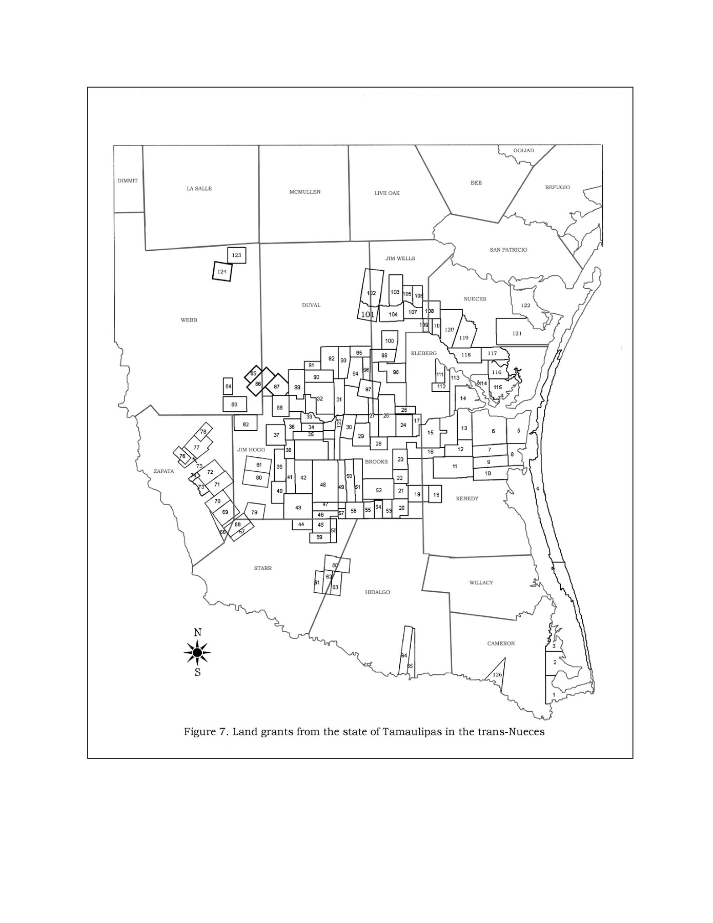
Land grants from the state of Tamaulipas in the trans-Nueces
- 
                          Map/Doc94040
- 
                            CollectionGeneral Map Collection
- 
                            Object Dates2009 (Creation Date)
- 
                            People and OrganizationsTexas General Land Office (Publisher)Galen D. Greaser (Author)Kevin Klaus (Author)Jeff Perkins (Author)
- 
                            CountiesWebb Cameron Willacy Hidalgo Starr Kenedy Nueces Kleberg Brooks Jim Hogg Zapata Dimmit Duval Jim Wells San Patricio Refugio Goliad Bee Live Oak McMullen La Salle
- 
                            SubjectsMexican Texas Spanish Texas
- 
                            Height x Width11.0 x 8.5 inches27.9 x 21.6 cm
- 
                            Mediumdigital image
- 
                            CommentsThese grants were made between 1821-1836 by the state of Tamaulipas.
 
 Figure 7 from the "New Guide to Spanish and Mexican Land Grants in South Texas", GLO Doc# 83388 (pp. 102-103).
 
 See 94041-94046 for other figures from this guide.
Related maps
            New Guide to Spanish and Mexican Land Grants in South Texas


                                            Price $15.00                    
                                    
                New Guide to Spanish and Mexican Land Grants in South Texas
2009
Size 11.0 x 8.5 inches
                                Map/Doc 83388
            
            Layout of the porciones as described in the Visita General of Camargo, 1767


            Layout of the porciones as described in the Visita General of Camargo, 1767
2009
Size 11.0 x 8.5 inches
                                Map/Doc 94041
            
            Layout of the porciones as described in the Visita General of Laredo, 1767


            Layout of the porciones as described in the Visita General of Laredo, 1767
2009
Size 11.0 x 8.5 inches
                                Map/Doc 94042
            
            Layout of the porciones as described in the Visita General of Mier, 1767


            Layout of the porciones as described in the Visita General of Mier, 1767
2009
Size 11.0 x 8.5 inches
                                Map/Doc 94043
            
            Layout of the porciones as described in the Visita General of Revilla (Guerrero), 1767, along with six tracts distributed by Gov. Lasaga in 1784 and three others (39-41) assigned at a later date


            Layout of the porciones as described in the Visita General of Revilla (Guerrero), 1767, along with six tracts distributed by Gov. Lasaga in 1784 and three others (39-41) assigned at a later date
2009
Size 11.0 x 8.5 inches
                                Map/Doc 94044
            
            Layout of the porciones as described in the Visita General of Reynosa, 1767


            Layout of the porciones as described in the Visita General of Reynosa, 1767
2009
Size 11.0 x 8.5 inches
                                Map/Doc 94045
            
            Spanish land grants (other than porciones) in the trans-Nueces


            Spanish land grants (other than porciones) in the trans-Nueces
2009
Size 11.0 x 8.5 inches
                                Map/Doc 94046
            Part of: General Map Collection
            Runnels County Rolled Sketch A


                                            Print $20.00                    
                                             -                         Digital $50.00                                    
                Runnels County Rolled Sketch A
1891
Size 13.4 x 15.0 inches
                                Map/Doc 7539
            
            San Patricio County Rolled Sketch 17


                                            Print $20.00                    
                                             -                         Digital $50.00                                    
                San Patricio County Rolled Sketch 17
1917
Size 18.1 x 28.1 inches
                                Map/Doc 7574
            
            Lamar County Sketch File 8


                                            Print $20.00                    
                                             -                         Digital $50.00                                    
                Lamar County Sketch File 8
1895
Size 21.4 x 23.1 inches
                                Map/Doc 11966
            
            El Paso Street and Vicinity Map (Recto)


            El Paso Street and Vicinity Map (Recto)
1962
Size 18.3 x 30.8 inches
                                Map/Doc 94175
            
            Morris County Rolled Sketch 2A


                                            Print $20.00                    
                                             -                         Digital $50.00                                    
                Morris County Rolled Sketch 2A
Size 36.2 x 19.3 inches
                                Map/Doc 10282
            
            Maps of Gulf Intracoastal Waterway, Texas - Sabine River to the Rio Grande and connecting waterways including ship channels


                                            Print $20.00                    
                                             -                         Digital $50.00                                    
                Maps of Gulf Intracoastal Waterway, Texas - Sabine River to the Rio Grande and connecting waterways including ship channels
1966
Size 14.6 x 22.2 inches
                                Map/Doc 61952
            
            Galveston County Working Sketch 20


                                            Print $20.00                    
                                             -                         Digital $50.00                                    
                Galveston County Working Sketch 20
1983
Size 28.1 x 38.0 inches
                                Map/Doc 69357
            
            Robertson County Rolled Sketch 1A


                                            Print $20.00                    
                                             -                         Digital $50.00                                    
                Robertson County Rolled Sketch 1A
1966
Size 45.3 x 28.1 inches
                                Map/Doc 9863
            
            Flight Mission No. CRC-3R, Frame 15, Chambers County


                                            Print $20.00                    
                                             -                         Digital $50.00                                    
                Flight Mission No. CRC-3R, Frame 15, Chambers County
1956
Size 18.5 x 22.2 inches
                                Map/Doc 84789
            
            Jim Hogg County Sketch File 10


                                            Print $22.00                    
                                             -                         Digital $50.00                                    
                Jim Hogg County Sketch File 10
1947
Size 14.3 x 8.7 inches
                                Map/Doc 28423
            
            Baylor County Boundary File 2


                                            Print $44.00                    
                                             -                         Digital $50.00                                    
                Baylor County Boundary File 2
Size 8.9 x 25.9 inches
                                Map/Doc 50359
            
            Atascosa County Sketch File 2b


                                            Print $6.00                    
                                             -                         Digital $50.00                                    
                Atascosa County Sketch File 2b
1855
Size 8.8 x 13.2 inches
                                Map/Doc 13728
            You may also like
            Marion County Sketch File 11


                                            Print $4.00                    
                                             -                         Digital $50.00                                    
                Marion County Sketch File 11
1902
Size 11.2 x 8.6 inches
                                Map/Doc 30581
            
            Zavalla [sic] County
            
                                    ![16938, Zavalla [sic] County, General Map Collection](https://historictexasmaps.com/wmedia_w700/maps/16938-1.tif.jpg) 


    ![16938, Zavalla [sic] County, General Map Collection](https://historictexasmaps.com/wmedia_w700/maps/16938-1.tif.jpg) 
                                
            
                                            Print $20.00                    
                                             -                         Digital $50.00                                    
                Zavalla [sic] County
1894
Size 42.3 x 44.6 inches
                                Map/Doc 16938
            
            Aransas County, Texas


                                            Print $20.00                    
                                             -                         Digital $50.00                                    
                Aransas County, Texas
1880
Size 19.3 x 20.2 inches
                                Map/Doc 665
            
            [Blocks S1, O6, D10, A4]
            
                                    ![90702, [Blocks S1, O6, D10, A4], Twichell Survey Records](https://historictexasmaps.com/wmedia_w700/maps/90702-1.tif.jpg) 


    ![90702, [Blocks S1, O6, D10, A4], Twichell Survey Records](https://historictexasmaps.com/wmedia_w700/maps/90702-1.tif.jpg) 
                                
            
                                            Print $20.00                    
                                             -                         Digital $50.00                                    
                [Blocks S1, O6, D10, A4]
Size 36.5 x 28.9 inches
                                Map/Doc 90702
            
            Flight Mission No. DQN-2K, Frame 29, Calhoun County


                                            Print $20.00                    
                                             -                         Digital $50.00                                    
                Flight Mission No. DQN-2K, Frame 29, Calhoun County
1953
Size 18.7 x 22.3 inches
                                Map/Doc 84236
            
            Flight Mission No. CGI-3N, Frame 180, Cameron County


                                            Print $20.00                    
                                             -                         Digital $50.00                                    
                Flight Mission No. CGI-3N, Frame 180, Cameron County
1954
Size 18.6 x 22.2 inches
                                Map/Doc 84644
            
            Stephens County Sketch File 6


                                            Print $4.00                    
                                             -                         Digital $50.00                                    
                Stephens County Sketch File 6
Size 9.1 x 9.1 inches
                                Map/Doc 37021
            
            Flight Mission No. CRC-4R, Frame 172, Chambers County


                                            Print $20.00                    
                                             -                         Digital $50.00                                    
                Flight Mission No. CRC-4R, Frame 172, Chambers County
1956
Size 18.6 x 22.3 inches
                                Map/Doc 84923
            
            Location of the Kansas City Shreveport & Gulf Railroad, Beaumont to Mayersburg


                                            Print $20.00                    
                                             -                         Digital $50.00                                    
                Location of the Kansas City Shreveport & Gulf Railroad, Beaumont to Mayersburg
1896
Size 26.0 x 36.5 inches
                                Map/Doc 64771
            
            Map of the country in the vicinity of San Antonio de Bexar reduced in part from the county map of Bexar with additions by J. Edmd. Blake, 1st Lieut Topl. Engs.


                                            Print $20.00                    
                                             -                         Digital $50.00                                    
                Map of the country in the vicinity of San Antonio de Bexar reduced in part from the county map of Bexar with additions by J. Edmd. Blake, 1st Lieut Topl. Engs.
1845
Size 18.1 x 25.7 inches
                                Map/Doc 72722
            
            Edwards County


                                            Print $20.00                    
                                             -                         Digital $50.00                                    
                Edwards County
1893
Size 26.7 x 30.2 inches
                                Map/Doc 4650
             
                            