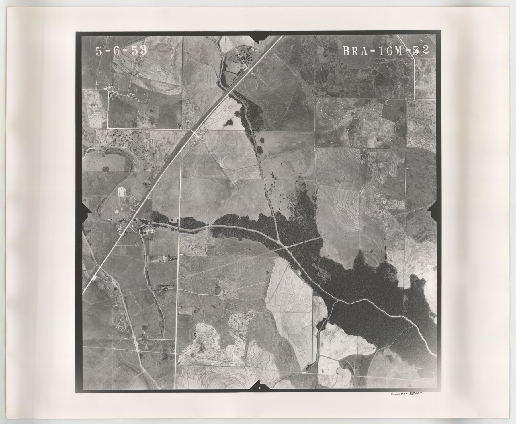
Flight Mission No. BRA-16M, Frame 52, Jefferson County
BRA-16M-52
-
Map/Doc
85669
-
Collection
General Map Collection
-
Object Dates
1953/5/6 (Creation Date)
-
People and Organizations
U. S. Department of Agriculture (Publisher)
-
Counties
Jefferson
-
Subjects
Aerial Photograph
-
Height x Width
18.5 x 22.6 inches
47.0 x 57.4 cm
-
Comments
Flown by Jack Ammann Photogrammetric Engineers of San Antonio, Texas.
Part of: General Map Collection
Duval County Sketch File 32b

Print $6.00
- Digital $50.00
Duval County Sketch File 32b
Size 14.2 x 8.9 inches
Map/Doc 21339
Flight Mission No. DCL-5C, Frame 76, Kenedy County

Print $20.00
- Digital $50.00
Flight Mission No. DCL-5C, Frame 76, Kenedy County
1943
Size 18.4 x 22.4 inches
Map/Doc 85859
Presidio County Rolled Sketch 44

Print $20.00
- Digital $50.00
Presidio County Rolled Sketch 44
1907
Size 14.3 x 25.3 inches
Map/Doc 7341
Upton County Working Sketch 2

Print $20.00
- Digital $50.00
Upton County Working Sketch 2
1906
Size 31.3 x 22.0 inches
Map/Doc 69498
Key to Photo Index Sheets of Texas Coast Portion

Print $20.00
- Digital $50.00
Key to Photo Index Sheets of Texas Coast Portion
1954
Size 20.0 x 24.0 inches
Map/Doc 83436
Plano General de la Ciudad de Mexico. Levantado Por el Teniente Coronel Don Diego Garcia Conde en el Año de 1793. Aumentado y corregido en lo mas notable Por el Teniente Coronel retirado, Don Rafael Maria Calvo En el de 1830

Print $20.00
- Digital $50.00
Plano General de la Ciudad de Mexico. Levantado Por el Teniente Coronel Don Diego Garcia Conde en el Año de 1793. Aumentado y corregido en lo mas notable Por el Teniente Coronel retirado, Don Rafael Maria Calvo En el de 1830
1793
Size 19.7 x 21.8 inches
Map/Doc 95354
Flight Mission No. DIX-6P, Frame 180, Aransas County

Print $20.00
- Digital $50.00
Flight Mission No. DIX-6P, Frame 180, Aransas County
1956
Size 19.0 x 22.6 inches
Map/Doc 83842
Hardin County Working Sketch 12

Print $20.00
- Digital $50.00
Hardin County Working Sketch 12
1934
Size 16.8 x 11.9 inches
Map/Doc 63410
Kimble County Working Sketch 90

Print $20.00
- Digital $50.00
Kimble County Working Sketch 90
1979
Size 17.3 x 28.2 inches
Map/Doc 70158
Comanche County Sketch File 6

Print $4.00
- Digital $50.00
Comanche County Sketch File 6
1854
Size 12.7 x 8.4 inches
Map/Doc 19061
Knox County Boundary File 3

Print $54.00
- Digital $50.00
Knox County Boundary File 3
Size 8.9 x 7.7 inches
Map/Doc 65019
[Sketch for Mineral Application 33721 - 33725 Incl. - Padre and Mustang Island]
![2877, [Sketch for Mineral Application 33721 - 33725 Incl. - Padre and Mustang Island], General Map Collection](https://historictexasmaps.com/wmedia_w700/maps/2877.tif.jpg)
Print $20.00
- Digital $50.00
[Sketch for Mineral Application 33721 - 33725 Incl. - Padre and Mustang Island]
1942
Size 29.8 x 22.6 inches
Map/Doc 2877
You may also like
Hartley County Working Sketch 5

Print $20.00
- Digital $50.00
Hartley County Working Sketch 5
1957
Size 46.3 x 28.9 inches
Map/Doc 66055
Flight Mission No. DAG-16K, Frame 70, Matagorda County

Print $20.00
- Digital $50.00
Flight Mission No. DAG-16K, Frame 70, Matagorda County
1952
Size 17.3 x 17.1 inches
Map/Doc 86316
Angelina County Sketch File 8

Print $22.00
- Digital $50.00
Angelina County Sketch File 8
1858
Size 8.0 x 3.5 inches
Map/Doc 12935
Reagan County Working Sketch 41
Print $20.00
- Digital $50.00
Reagan County Working Sketch 41
1973
Size 28.6 x 38.9 inches
Map/Doc 71883
Harris County Rolled Sketch F

Print $40.00
- Digital $50.00
Harris County Rolled Sketch F
1933
Size 56.6 x 44.6 inches
Map/Doc 9121
[North part of County with connecting lines]
![89955, [North part of County with connecting lines], Twichell Survey Records](https://historictexasmaps.com/wmedia_w700/maps/89955-1.tif.jpg)
Print $40.00
- Digital $50.00
[North part of County with connecting lines]
Size 51.3 x 35.0 inches
Map/Doc 89955
Wharton County Sketch File A3

Print $26.00
- Digital $50.00
Wharton County Sketch File A3
1899
Size 18.2 x 18.6 inches
Map/Doc 12671
Galveston County Working Sketch 15

Print $20.00
- Digital $50.00
Galveston County Working Sketch 15
1978
Size 32.0 x 27.8 inches
Map/Doc 69352
Clay County Working Sketch 2

Print $20.00
- Digital $50.00
Clay County Working Sketch 2
1907
Size 26.5 x 16.2 inches
Map/Doc 68025
Presidio County Working Sketch 130

Print $20.00
- Digital $50.00
Presidio County Working Sketch 130
1989
Size 22.1 x 43.1 inches
Map/Doc 71808
Wilbarger County Sketch File 23

Print $4.00
- Digital $50.00
Wilbarger County Sketch File 23
1887
Size 14.2 x 8.8 inches
Map/Doc 40223
Comanche County Working Sketch 16

Print $20.00
- Digital $50.00
Comanche County Working Sketch 16
1969
Size 16.5 x 23.8 inches
Map/Doc 68150