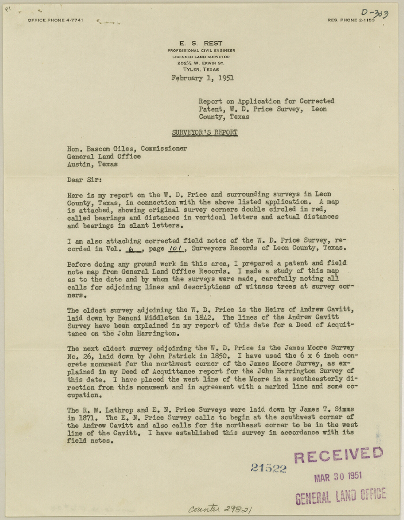
Leon County Sketch File 28
[Report on application for corrected patent, W. D. Price survey]
-
Map/Doc
29821
-
Collection
General Map Collection
-
Object Dates
3/30/1951 (Creation Date)
3/30/1951 (File Date)
-
People and Organizations
E.S. Rest (Surveyor/Engineer)
-
Counties
Leon
-
Subjects
Surveying Sketch File
-
Height x Width
11.2 x 8.7 inches
28.4 x 22.1 cm
-
Medium
paper, print
Part of: General Map Collection
Midland County Rolled Sketch 8

Print $80.00
- Digital $50.00
Midland County Rolled Sketch 8
1952
Size 39.8 x 17.8 inches
Map/Doc 6765
McLennan County Sketch File 25

Print $2.00
- Digital $50.00
McLennan County Sketch File 25
Size 8.8 x 12.3 inches
Map/Doc 31299
Bastrop County Rolled Sketch 6

Print $20.00
- Digital $50.00
Bastrop County Rolled Sketch 6
2013
Size 42.3 x 32.1 inches
Map/Doc 93716
[F. W. & D. C. Ry. Co. Alignment and Right of Way Map, Clay County]
![64728, [F. W. & D. C. Ry. Co. Alignment and Right of Way Map, Clay County], General Map Collection](https://historictexasmaps.com/wmedia_w700/maps/64728-1.tif.jpg)
Print $20.00
- Digital $50.00
[F. W. & D. C. Ry. Co. Alignment and Right of Way Map, Clay County]
1927
Size 18.8 x 11.7 inches
Map/Doc 64728
Hidalgo County Sketch File 8

Print $4.00
- Digital $50.00
Hidalgo County Sketch File 8
1890
Size 14.1 x 8.6 inches
Map/Doc 26407
Station Map, the Missouri, Kansas and Texas Ry. Of Texas - Henrietta Division

Print $20.00
- Digital $50.00
Station Map, the Missouri, Kansas and Texas Ry. Of Texas - Henrietta Division
1918
Size 11.7 x 26.8 inches
Map/Doc 64764
Galveston County Rolled Sketch Z62

Print $20.00
- Digital $50.00
Galveston County Rolled Sketch Z62
1933
Size 34.7 x 22.7 inches
Map/Doc 5994
Titus County Sketch File 3

Print $40.00
- Digital $50.00
Titus County Sketch File 3
1852
Size 19.9 x 8.4 inches
Map/Doc 38134
Flight Mission No. DCL-6C, Frame 117, Kenedy County

Print $20.00
- Digital $50.00
Flight Mission No. DCL-6C, Frame 117, Kenedy County
1943
Size 18.5 x 22.2 inches
Map/Doc 85947
Midland County Working Sketch 15

Print $20.00
- Digital $50.00
Midland County Working Sketch 15
1953
Size 27.2 x 28.6 inches
Map/Doc 70995
Kendall County Working Sketch 9

Print $40.00
- Digital $50.00
Kendall County Working Sketch 9
1953
Size 52.8 x 37.2 inches
Map/Doc 66681
Llano County Boundary File 3

Print $42.00
- Digital $50.00
Llano County Boundary File 3
Size 14.1 x 8.7 inches
Map/Doc 56449
You may also like
Foard County Sketch File 1

Print $6.00
- Digital $50.00
Foard County Sketch File 1
Size 10.0 x 9.5 inches
Map/Doc 22804
Flight Mission No. DIX-10P, Frame 80, Aransas County

Print $20.00
- Digital $50.00
Flight Mission No. DIX-10P, Frame 80, Aransas County
1956
Size 18.8 x 22.4 inches
Map/Doc 83941
Presidio County Working Sketch 23

Print $20.00
- Digital $50.00
Presidio County Working Sketch 23
1945
Size 35.7 x 23.3 inches
Map/Doc 71699

Hutchinson County Rolled Sketch 44-15

Print $20.00
- Digital $50.00
Hutchinson County Rolled Sketch 44-15
2002
Size 24.0 x 36.0 inches
Map/Doc 77551
Grayson County Working Sketch 5

Print $20.00
- Digital $50.00
Grayson County Working Sketch 5
1939
Size 28.4 x 40.6 inches
Map/Doc 63244
Hudspeth County Sketch File 8

Print $20.00
- Digital $50.00
Hudspeth County Sketch File 8
1886
Size 40.7 x 43.3 inches
Map/Doc 10493
Brewster County Working Sketch 32

Print $20.00
- Digital $50.00
Brewster County Working Sketch 32
1943
Size 28.3 x 28.3 inches
Map/Doc 67566
Archer County Working Sketch 18

Print $20.00
- Digital $50.00
Archer County Working Sketch 18
1957
Size 20.2 x 22.9 inches
Map/Doc 67159
Outer Continental Shelf Leasing Maps (Louisiana Offshore Operations)

Print $20.00
- Digital $50.00
Outer Continental Shelf Leasing Maps (Louisiana Offshore Operations)
1959
Size 18.3 x 14.5 inches
Map/Doc 76112
Titus County Working Sketch 8

Print $20.00
- Digital $50.00
Titus County Working Sketch 8
1974
Size 17.6 x 29.3 inches
Map/Doc 69369
[Leagues 615, 616, and vicinity]
![91004, [Leagues 615, 616, and vicinity], Twichell Survey Records](https://historictexasmaps.com/wmedia_w700/maps/91004-1.tif.jpg)
Print $20.00
- Digital $50.00
[Leagues 615, 616, and vicinity]
Size 12.9 x 12.3 inches
Map/Doc 91004