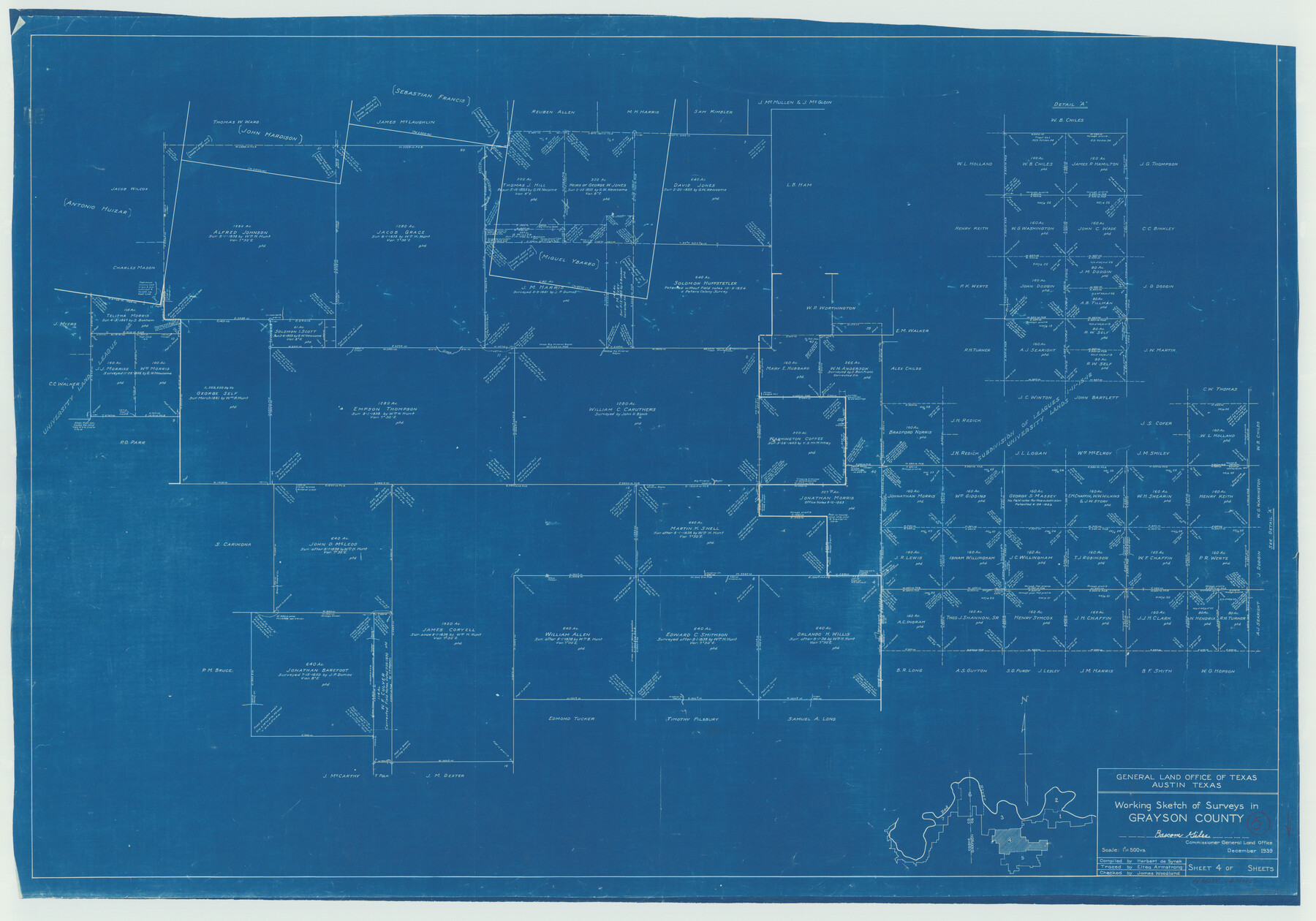
Grayson County Working Sketch 5
-
Map/Doc
63244
-
Collection
General Map Collection
-
Object Dates
12/1939 (Creation Date)
-
People and Organizations
Herbert de Synek (Compiler)
Eltea Armstrong (Tracer)
-
Counties
Grayson
-
Subjects
Surveying Working Sketch
-
Height x Width
28.4 x 40.6 inches
72.1 x 103.1 cm
-
Scale
1" = 500 varas
Part of: General Map Collection
Zavala County Sketch File 11b

Print $4.00
- Digital $50.00
Zavala County Sketch File 11b
1886
Size 10.2 x 8.3 inches
Map/Doc 41277
Cherokee County Sketch File 31

Print $6.00
- Digital $50.00
Cherokee County Sketch File 31
1934
Size 14.0 x 8.9 inches
Map/Doc 18184
Township No. 1 South Range No. 21 West of the Indian Meridian

Print $20.00
- Digital $50.00
Township No. 1 South Range No. 21 West of the Indian Meridian
1875
Size 19.2 x 24.5 inches
Map/Doc 75178
Map of Corpus Christi Bay in Nueces County Showing Subdivision Thereof for Mineral Development

Print $40.00
- Digital $50.00
Map of Corpus Christi Bay in Nueces County Showing Subdivision Thereof for Mineral Development
1946
Size 55.9 x 43.3 inches
Map/Doc 2942
D No. 4 - Reconnaissance of New River and Bar, North Carolina

Print $20.00
- Digital $50.00
D No. 4 - Reconnaissance of New River and Bar, North Carolina
1852
Size 19.4 x 15.7 inches
Map/Doc 97211
Brewster County Working Sketch 75

Print $20.00
- Digital $50.00
Brewster County Working Sketch 75
1967
Size 28.3 x 36.9 inches
Map/Doc 67675
Brazoria County Sketch File 31

Print $40.00
- Digital $50.00
Brazoria County Sketch File 31
1894
Size 17.4 x 14.4 inches
Map/Doc 15039
Stephens County Working Sketch 25

Print $20.00
- Digital $50.00
Stephens County Working Sketch 25
1976
Size 37.4 x 32.3 inches
Map/Doc 63968
Comal County Working Sketch 18

Print $20.00
- Digital $50.00
Comal County Working Sketch 18
2000
Size 32.0 x 31.7 inches
Map/Doc 68182
Jeff Davis County Sketch File 41

Print $40.00
- Digital $50.00
Jeff Davis County Sketch File 41
1959
Size 13.3 x 13.4 inches
Map/Doc 28064
University Lands Situated in Robertson County

Print $20.00
- Digital $50.00
University Lands Situated in Robertson County
1841
Size 22.8 x 26.2 inches
Map/Doc 281
Potter County Boundary File 6b

Print $20.00
- Digital $50.00
Potter County Boundary File 6b
Size 37.9 x 8.7 inches
Map/Doc 58040
You may also like
Mills County Working Sketch 5

Print $3.00
- Digital $50.00
Mills County Working Sketch 5
1914
Size 13.1 x 10.8 inches
Map/Doc 71035
Trinity County Working Sketch 22

Print $40.00
- Digital $50.00
Trinity County Working Sketch 22
2009
Size 32.0 x 52.1 inches
Map/Doc 89068
Flight Mission No. CRC-3R, Frame 9, Chambers County

Print $20.00
- Digital $50.00
Flight Mission No. CRC-3R, Frame 9, Chambers County
1956
Size 18.7 x 22.4 inches
Map/Doc 84783
The Chief Justice County of Shelby. Undated

Print $20.00
The Chief Justice County of Shelby. Undated
2020
Size 23.5 x 21.7 inches
Map/Doc 96074
Colorado County Working Sketch 25

Print $20.00
- Digital $50.00
Colorado County Working Sketch 25
1972
Size 39.1 x 34.2 inches
Map/Doc 68125
Matagorda County Texas

Print $20.00
- Digital $50.00
Matagorda County Texas
1896
Size 30.8 x 27.3 inches
Map/Doc 3845
[Sketch of common corner of Oldham, Potter, Deaf Smith and Randall Counties]
![93060, [Sketch of common corner of Oldham, Potter, Deaf Smith and Randall Counties], Twichell Survey Records](https://historictexasmaps.com/wmedia_w700/maps/93060-1.tif.jpg)
Print $20.00
- Digital $50.00
[Sketch of common corner of Oldham, Potter, Deaf Smith and Randall Counties]
Size 17.2 x 33.1 inches
Map/Doc 93060
Map of the World on Mercator's Projection, flags of all nations and cities of the United States

Print $40.00
- Digital $50.00
Map of the World on Mercator's Projection, flags of all nations and cities of the United States
1874
Size 40.4 x 55.6 inches
Map/Doc 93914
Pecos County Working Sketch 42

Print $20.00
- Digital $50.00
Pecos County Working Sketch 42
1942
Size 31.3 x 23.9 inches
Map/Doc 71514
Edwards Empresario Colony. April 15, 1825

Print $20.00
Edwards Empresario Colony. April 15, 1825
2020
Size 18.1 x 21.6 inches
Map/Doc 95993

Outer Continental Shelf Leasing Maps (Louisiana Offshore Operations)

Print $20.00
- Digital $50.00
Outer Continental Shelf Leasing Maps (Louisiana Offshore Operations)
1955
Size 12.4 x 12.7 inches
Map/Doc 76086