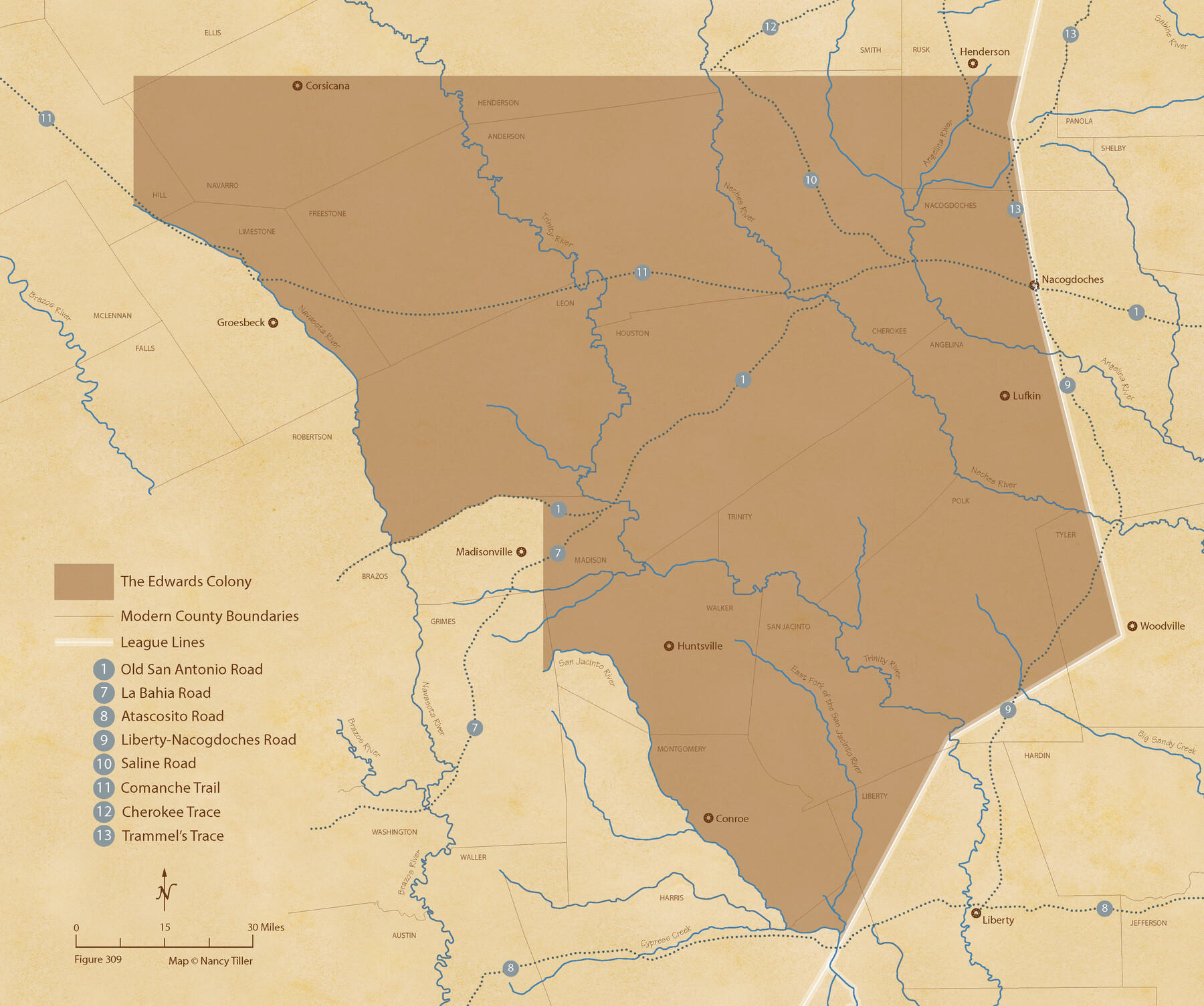
Edwards Empresario Colony. April 15, 1825
Figure No. 309 from 'A Boundary Atlas of Texas, 1821-1845' by Jim Tiller
-
Map/Doc
95993
-
Collection
Nancy and Jim Tiller Digital Collection
-
Object Dates
2020/1/1 (Creation Date)
-
People and Organizations
Jim Tiller (Author)
Nancy Tiller (Cartographer)
Gang Gong (GIS Professional)
-
Subjects
Atlas Colony Mexican Texas Texas Boundaries
-
Height x Width
18.1 x 21.6 inches
46.0 x 54.9 cm
-
Medium
digital image
-
Comments
To purchase a digital PDF copy of "A Boundary Atlas of Texas, 1821-1845" see 96437.
Part of: Nancy and Jim Tiller Digital Collection
The Republic County of Goliad. Proposed, Late Fall 1837

Print $20.00
The Republic County of Goliad. Proposed, Late Fall 1837
2020
Size 15.1 x 21.7 inches
Map/Doc 96147
The Mexican Department of Bexar. Created, 1827

Print $20.00
The Mexican Department of Bexar. Created, 1827
2020
Size 16.6 x 21.7 inches
Map/Doc 95967
From Citizens of Southwestern Nacogdoches County for the Creation of a New Judicial County (Unnamed), Undated

Print $20.00
From Citizens of Southwestern Nacogdoches County for the Creation of a New Judicial County (Unnamed), Undated
2020
Size 19.9 x 21.7 inches
Map/Doc 96412
The Republic County of Victoria. September 18, 1838

Print $20.00
The Republic County of Victoria. September 18, 1838
2020
Size 24.3 x 21.7 inches
Map/Doc 96296
Purnell and Lovell Empresario Colony. October 22, 1825

Print $20.00
Purnell and Lovell Empresario Colony. October 22, 1825
2020
Size 18.1 x 21.6 inches
Map/Doc 96005
The Republic County of Jasper. Boundaries Defined, December 14, 1837

Print $20.00
The Republic County of Jasper. Boundaries Defined, December 14, 1837
2020
Size 19.5 x 21.7 inches
Map/Doc 96193
The Peters Colony. November 9, 1841

Print $20.00
The Peters Colony. November 9, 1841
2020
Size 21.7 x 21.7 inches
Map/Doc 96363
The Chief Justice County of Harrisburg. January 30, 1837

Print $20.00
The Chief Justice County of Harrisburg. January 30, 1837
2020
Size 17.5 x 21.7 inches
Map/Doc 96049
The Republic County of Robertson. Spring 1842

Print $20.00
The Republic County of Robertson. Spring 1842
2020
Size 16.9 x 21.7 inches
Map/Doc 96263
Filisola Empresario Colony. October 15, 1831

Print $20.00
Filisola Empresario Colony. October 15, 1831
2020
Size 15.3 x 21.7 inches
Map/Doc 95995
Burnet Empresario Colony. December 22, 1826

Print $20.00
Burnet Empresario Colony. December 22, 1826
2020
Size 12.9 x 21.6 inches
Map/Doc 95985
The Republic County of Liberty. December 7, 1841

Print $20.00
The Republic County of Liberty. December 7, 1841
2020
Size 19.9 x 21.7 inches
Map/Doc 96211
You may also like
Flight Mission No. CUG-1P, Frame 112, Kleberg County

Print $20.00
- Digital $50.00
Flight Mission No. CUG-1P, Frame 112, Kleberg County
1956
Size 18.5 x 22.3 inches
Map/Doc 86162
Block 2 T. & N. Ry. Co., Block 97 H. T. C. Ry. Co.

Print $40.00
- Digital $50.00
Block 2 T. & N. Ry. Co., Block 97 H. T. C. Ry. Co.
1888
Size 41.5 x 48.1 inches
Map/Doc 89874
Nacogdoches County Working Sketch 8

Print $20.00
- Digital $50.00
Nacogdoches County Working Sketch 8
1964
Size 28.0 x 22.7 inches
Map/Doc 71224
Flight Mission No. DCL-6C, Frame 50, Kenedy County

Print $20.00
- Digital $50.00
Flight Mission No. DCL-6C, Frame 50, Kenedy County
1943
Size 18.7 x 22.4 inches
Map/Doc 85892
Wood County Working Sketch 1

Print $20.00
- Digital $50.00
Wood County Working Sketch 1
1904
Size 19.7 x 16.2 inches
Map/Doc 62001
Map of Travis County

Print $20.00
- Digital $50.00
Map of Travis County
1861
Size 24.0 x 28.6 inches
Map/Doc 4088
Jefferson County Rolled Sketch 60

Print $20.00
- Digital $50.00
Jefferson County Rolled Sketch 60
1885
Size 31.0 x 35.6 inches
Map/Doc 9315
Palo Pinto County Boundary File 4a

Print $34.00
- Digital $50.00
Palo Pinto County Boundary File 4a
Size 13.3 x 8.9 inches
Map/Doc 57817
[Surveys along the Frio River]
![129, [Surveys along the Frio River], General Map Collection](https://historictexasmaps.com/wmedia_w700/maps/129.tif.jpg)
Print $20.00
- Digital $50.00
[Surveys along the Frio River]
1841
Size 12.0 x 16.6 inches
Map/Doc 129
Shelby County Sketch File 9

Print $4.00
- Digital $50.00
Shelby County Sketch File 9
1858
Size 9.4 x 8.2 inches
Map/Doc 36609

Flight Mission No. BQR-7K, Frame 33, Brazoria County

Print $20.00
- Digital $50.00
Flight Mission No. BQR-7K, Frame 33, Brazoria County
1952
Size 18.7 x 22.3 inches
Map/Doc 84031