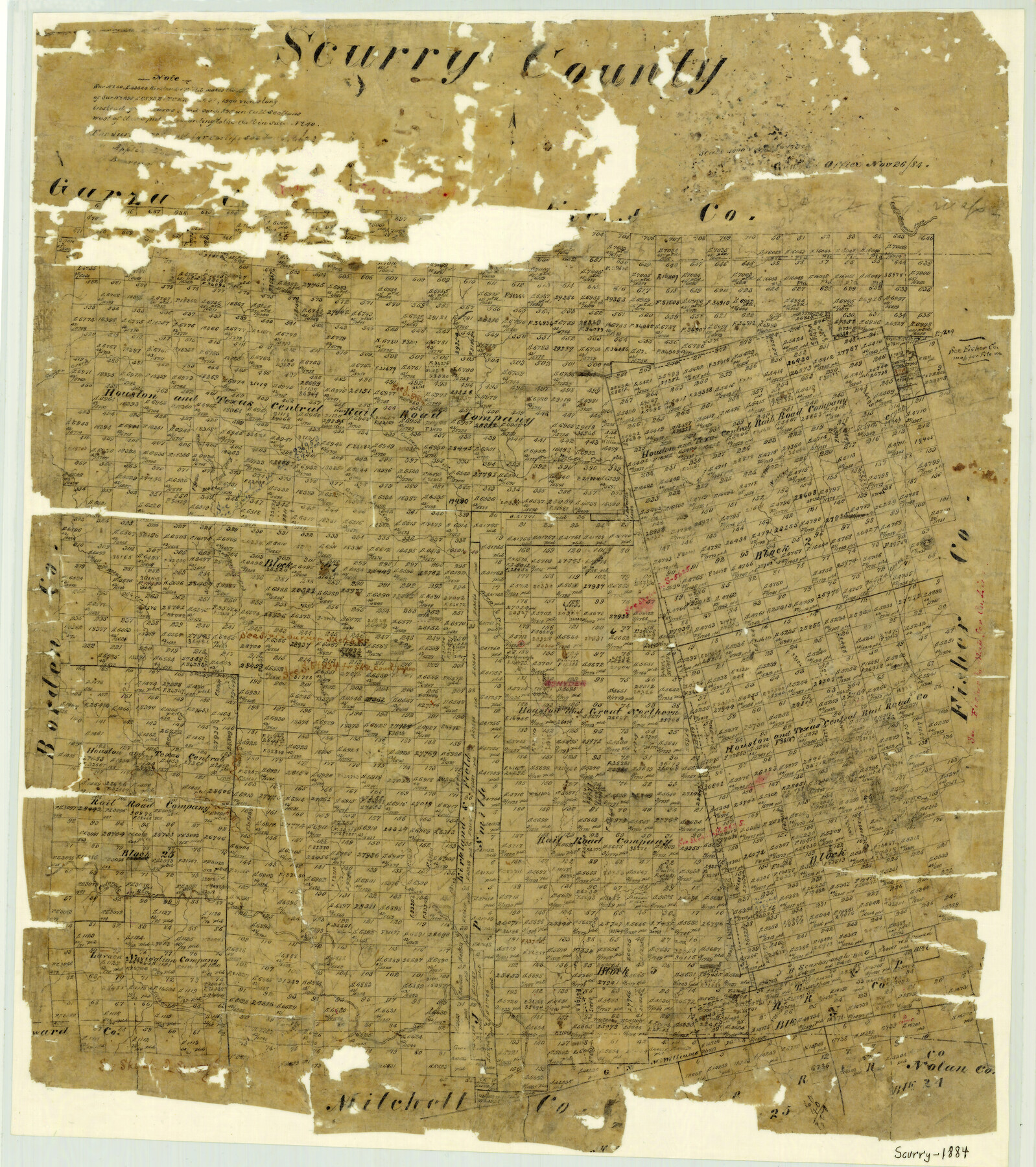
Scurry County
-
Map/Doc
4024
-
Collection
General Map Collection
-
Object Dates
1884/11/26 (Creation Date)
-
People and Organizations
Texas General Land Office (Publisher)
-
Counties
Scurry
-
Subjects
County
-
Height x Width
21.4 x 19.0 inches
54.4 x 48.3 cm
-
Features
Snyder
South Prong [of Watson's Branch of Colorado River]
North Prong [of Watson's Branch of Colorado River]
Watson's Branch [of Colorado River]
North Prong [of Sulphur Creek]
Gopher Creek
Willie's Creek
Sulphur Creek
Cañon Creek
Colorado River
Viola Creek
Deer Creek
North Creek
Double Mountain Fork
Elm Fork
Alice Creek
Deep Creek
Etta's Creek
Moccasin Creek
West Prong [of Moccasin Creek]
East Prong [of Moccasin Creek]
Guires Creek
Sweet Water Creek
Culvers Creek
Conner Creek
Part of: General Map Collection
Schleicher County Working Sketch 9

Print $20.00
- Digital $50.00
Schleicher County Working Sketch 9
1923
Size 12.4 x 11.8 inches
Map/Doc 63811
Navarro County Sketch File 14

Print $4.00
- Digital $50.00
Navarro County Sketch File 14
1873
Size 8.4 x 10.2 inches
Map/Doc 32326
Map of Kimble County

Print $20.00
- Digital $50.00
Map of Kimble County
1879
Size 18.7 x 28.9 inches
Map/Doc 3765
J. De Cordova's Map of the State of Texas Compiled from the records of the General Land Office of the State

Print $20.00
- Digital $50.00
J. De Cordova's Map of the State of Texas Compiled from the records of the General Land Office of the State
1851
Size 34.9 x 32.0 inches
Map/Doc 442
Hockley County

Print $20.00
- Digital $50.00
Hockley County
1954
Size 42.9 x 38.9 inches
Map/Doc 1856
Hale County Rolled Sketch 6

Print $20.00
- Digital $50.00
Hale County Rolled Sketch 6
1903
Size 35.0 x 28.9 inches
Map/Doc 6045
Crockett County Working Sketch 26

Print $20.00
- Digital $50.00
Crockett County Working Sketch 26
1922
Size 15.3 x 20.3 inches
Map/Doc 68359
Flight Mission No. DQN-5K, Frame 27, Calhoun County

Print $20.00
- Digital $50.00
Flight Mission No. DQN-5K, Frame 27, Calhoun County
1953
Size 18.4 x 22.1 inches
Map/Doc 84378
Galveston County Rolled Sketch 46

Print $40.00
- Digital $50.00
Galveston County Rolled Sketch 46
2000
Size 32.0 x 48.3 inches
Map/Doc 5981
Coleman County Working Sketch 16

Print $20.00
- Digital $50.00
Coleman County Working Sketch 16
1950
Size 41.7 x 35.7 inches
Map/Doc 68082
Dawson County Sketch File 10

Print $4.00
- Digital $50.00
Dawson County Sketch File 10
1927
Size 11.4 x 8.8 inches
Map/Doc 20544
Pecos County Working Sketch 129

Print $20.00
- Digital $50.00
Pecos County Working Sketch 129
1976
Map/Doc 71603
You may also like
Map of the State of Texas from the Latest Authorities

Print $20.00
- Digital $50.00
Map of the State of Texas from the Latest Authorities
1854
Size 13.1 x 16.1 inches
Map/Doc 93901
Controlled Mosaic by Jack Amman Photogrammetric Engineers, Inc - Sheet 15

Print $20.00
- Digital $50.00
Controlled Mosaic by Jack Amman Photogrammetric Engineers, Inc - Sheet 15
1954
Size 20.0 x 24.0 inches
Map/Doc 83459
Sutton County Sketch File 42

Print $6.00
- Digital $50.00
Sutton County Sketch File 42
1940
Size 11.2 x 8.8 inches
Map/Doc 37509
Coryell County Boundary File 1 and 1a

Print $8.00
- Digital $50.00
Coryell County Boundary File 1 and 1a
Size 8.2 x 3.3 inches
Map/Doc 51890


Gregg County Sketch File 1E

Print $4.00
- Digital $50.00
Gregg County Sketch File 1E
1849
Size 12.6 x 8.2 inches
Map/Doc 24545
Presidio de San Antonio de Bejar y Villa de San Fernando

Print $20.00
- Digital $50.00
Presidio de San Antonio de Bejar y Villa de San Fernando
1986
Size 21.8 x 26.0 inches
Map/Doc 87386
Flight Mission No. DQO-3K, Frame 82, Galveston County

Print $20.00
- Digital $50.00
Flight Mission No. DQO-3K, Frame 82, Galveston County
1952
Size 18.7 x 22.5 inches
Map/Doc 85087
King County Boundary File 1

Print $46.00
- Digital $50.00
King County Boundary File 1
Size 14.2 x 8.6 inches
Map/Doc 64873
[Texas and Pacific Railroad Co. Blocks 55, 54 and 76, Townships 1 & 2]
![89882, [Texas and Pacific Railroad Co. Blocks 55, 54 and 76, Townships 1 & 2], Twichell Survey Records](https://historictexasmaps.com/wmedia_w700/maps/89882-1.tif.jpg)
Print $20.00
- Digital $50.00
[Texas and Pacific Railroad Co. Blocks 55, 54 and 76, Townships 1 & 2]
Size 46.2 x 41.5 inches
Map/Doc 89882
Williamson County Rolled Sketch 9

Print $20.00
- Digital $50.00
Williamson County Rolled Sketch 9
Size 25.3 x 32.8 inches
Map/Doc 8266