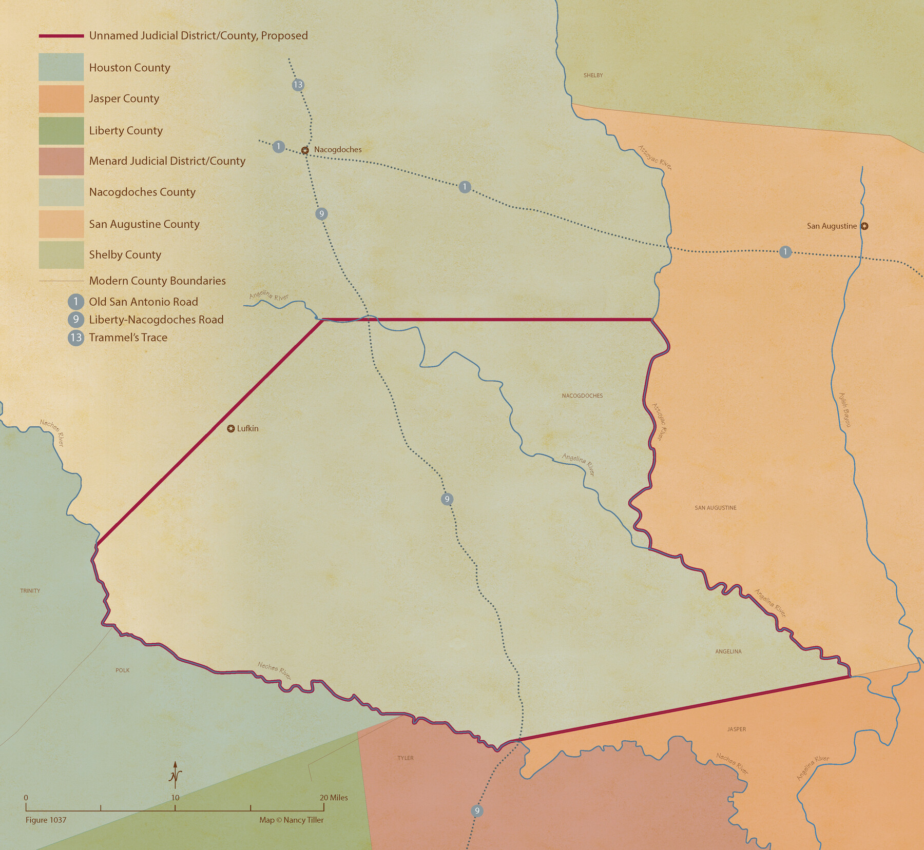
From Citizens of Southwestern Nacogdoches County for the Creation of a New Judicial County (Unnamed), Undated
Figure No. 1037 from 'A Boundary Atlas of Texas, 1821-1845' by Jim Tiller
-
Map/Doc
96412
-
Collection
Nancy and Jim Tiller Digital Collection
-
Object Dates
2020/1/1 (Creation Date)
-
People and Organizations
Jim Tiller (Author)
Nancy Tiller (Cartographer)
Gang Gong (GIS Professional)
-
Subjects
Atlas Republic of Texas Texas Boundaries
-
Height x Width
19.9 x 21.7 inches
50.6 x 55.1 cm
-
Medium
digital image
-
Comments
To purchase a digital PDF copy of "A Boundary Atlas of Texas, 1821-1845" see 96437.
Part of: Nancy and Jim Tiller Digital Collection
The Mexican Department of Nacogdoches. Created, January 31, 1831

Print $20.00
The Mexican Department of Nacogdoches. Created, January 31, 1831
2020
Size 18.4 x 21.7 inches
Map/Doc 95972
The Republic County of Brazoria. Proposed, Late Fall 1837-January 1, 1838

Print $20.00
The Republic County of Brazoria. Proposed, Late Fall 1837-January 1, 1838
2020
Size 13.0 x 21.7 inches
Map/Doc 96110
The Republic County of Victoria. January 29, 1842

Print $20.00
The Republic County of Victoria. January 29, 1842
2020
Size 24.3 x 21.7 inches
Map/Doc 96298
The Republic County of Bexar. November 28, 1839

Print $20.00
The Republic County of Bexar. November 28, 1839
2020
Size 14.8 x 21.1 inches
Map/Doc 96097
Republic Counties. December 29, 1845

Print $20.00
Republic Counties. December 29, 1845
2020
Size 24.5 x 21.7 inches
Map/Doc 96319
The Mexican Municipality of Gonzales. April 1834

Print $20.00
The Mexican Municipality of Gonzales. April 1834
2020
Size 20.4 x 21.7 inches
Map/Doc 96021
Wavell Empresario Colony. Proposed, March 9, 1826

Print $20.00
Wavell Empresario Colony. Proposed, March 9, 1826
2020
Size 16.0 x 21.7 inches
Map/Doc 96009
The Republic County of San Patricio. Proposed, Late Fall 1837-December 31, 1838

Print $20.00
The Republic County of San Patricio. Proposed, Late Fall 1837-December 31, 1838
2020
Size 22.2 x 21.7 inches
Map/Doc 96274
The Republic County of Goliad. Proposed, Late Fall 1837

Print $20.00
The Republic County of Goliad. Proposed, Late Fall 1837
2020
Size 15.1 x 21.7 inches
Map/Doc 96147
The Republic County of Jasper. December 29, 1845

Print $20.00
The Republic County of Jasper. December 29, 1845
2020
Size 19.5 x 21.7 inches
Map/Doc 96196
Geographical Observations on the Inner Margins of the Border and Coastal Reserves of Texas, 1824-1836

Geographical Observations on the Inner Margins of the Border and Coastal Reserves of Texas, 1824-1836
2022
Map/Doc 97131
The Fisher-Miller Colony. September 1, 1843

Print $20.00
The Fisher-Miller Colony. September 1, 1843
2020
Size 13.8 x 21.7 inches
Map/Doc 96359
You may also like
Denton County Working Sketch 25

Print $20.00
- Digital $50.00
Denton County Working Sketch 25
1990
Size 13.7 x 18.0 inches
Map/Doc 68630
Flight Mission No. DCL-7C, Frame 75, Kenedy County

Print $20.00
- Digital $50.00
Flight Mission No. DCL-7C, Frame 75, Kenedy County
1943
Size 15.3 x 15.2 inches
Map/Doc 86061

A new map of Texas, Oregon and California with the regions adjoining, compiled from the most recent authorities

Print $20.00
- Digital $50.00
A new map of Texas, Oregon and California with the regions adjoining, compiled from the most recent authorities
1846
Size 23.7 x 21.8 inches
Map/Doc 93940
Bosque County Working Sketch 4

Print $20.00
- Digital $50.00
Bosque County Working Sketch 4
1901
Size 14.2 x 18.6 inches
Map/Doc 67437
Houston County Sketch File 33

Print $20.00
- Digital $50.00
Houston County Sketch File 33
1894
Size 16.9 x 18.4 inches
Map/Doc 11790
Flight Mission No. DCL-7C, Frame 6, Kenedy County

Print $20.00
- Digital $50.00
Flight Mission No. DCL-7C, Frame 6, Kenedy County
1943
Size 15.5 x 15.4 inches
Map/Doc 85998
Flight Mission No. DAG-4C, Frame 150, Matagorda County

Print $20.00
- Digital $50.00
Flight Mission No. DAG-4C, Frame 150, Matagorda County
1943
Size 18.5 x 18.4 inches
Map/Doc 86441
Harris County Working Sketch 68

Print $20.00
- Digital $50.00
Harris County Working Sketch 68
1955
Size 29.3 x 24.3 inches
Map/Doc 65960
[University Lands in West Texas]
![2422, [University Lands in West Texas], General Map Collection](https://historictexasmaps.com/wmedia_w700/maps/2422.tif.jpg)
Print $20.00
- Digital $50.00
[University Lands in West Texas]
1938
Size 20.3 x 28.1 inches
Map/Doc 2422
Brewster County Working Sketch 118

Print $20.00
- Digital $50.00
Brewster County Working Sketch 118
1929
Size 27.0 x 20.5 inches
Map/Doc 67718
Bosque County, Texas School Map

Print $20.00
- Digital $50.00
Bosque County, Texas School Map
1932
Size 40.9 x 36.6 inches
Map/Doc 81918