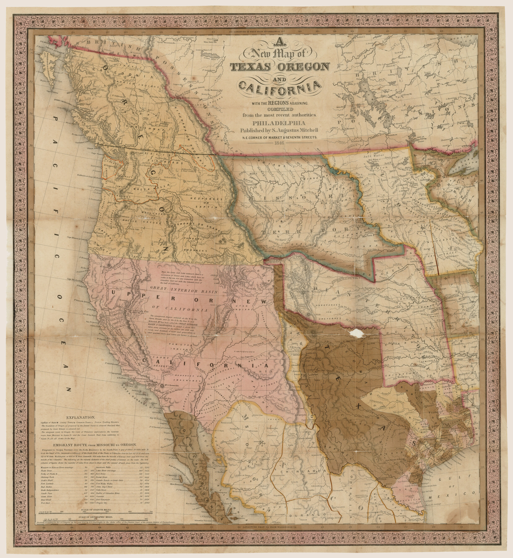
A new map of Texas, Oregon and California with the regions adjoining, compiled from the most recent authorities
-
Map/Doc
93940
-
Collection
Rees-Jones Digital Map Collection
-
Object Dates
1846 (Creation Date)
-
People and Organizations
S. Augustus Mitchell (Publisher)
-
Subjects
New Southwest Republic of Texas
-
Height x Width
23.7 x 21.8 inches
60.2 x 55.4 cm
-
Comments
Courtesy of the Rees-Jones Collection, Dallas, TX
Part of: Rees-Jones Digital Map Collection
Chart of the World shewing the tracks of the U.S. Exploring Expedition in 1833, 39, 40, 41 & 42

Print $20.00
- Digital $50.00
Chart of the World shewing the tracks of the U.S. Exploring Expedition in 1833, 39, 40, 41 & 42
1842
Size 26.3 x 37.4 inches
Map/Doc 94057
J.K Gill & Cos Map of Oregon

Print $20.00
- Digital $50.00
J.K Gill & Cos Map of Oregon
1882
Size 29.0 x 32.3 inches
Map/Doc 94055
Geological Map of the United States and the British Provinces of North America

Print $20.00
- Digital $50.00
Geological Map of the United States and the British Provinces of North America
Size 23.4 x 35.9 inches
Map/Doc 93988
Part of the boundary between the United States and Texas; north of Sabine River, from the 72nd mile mound to the Red River

Print $3.00
- Digital $50.00
Part of the boundary between the United States and Texas; north of Sabine River, from the 72nd mile mound to the Red River
1842
Size 12.8 x 8.1 inches
Map/Doc 93771
Rand, McNally & Co's New Mexico

Print $20.00
- Digital $50.00
Rand, McNally & Co's New Mexico
1880
Size 21.4 x 14.7 inches
Map/Doc 94050
J. De Cordova's Map of the State of Texas Compiled from the records of the General Land Office of the State

Print $20.00
- Digital $50.00
J. De Cordova's Map of the State of Texas Compiled from the records of the General Land Office of the State
1867
Size 38.0 x 35.4 inches
Map/Doc 93759
Sabine Pass and mouth of the River Sabine in the sea

Print $20.00
- Digital $50.00
Sabine Pass and mouth of the River Sabine in the sea
1842
Size 24.0 x 19.1 inches
Map/Doc 93766
Nebraska and Kansas

Print $20.00
- Digital $50.00
Nebraska and Kansas
Size 14.7 x 16.7 inches
Map/Doc 93997
Map of the River Sabine from Logan's Ferry to 32nd degree of north latitude

Print $3.00
- Digital $50.00
Map of the River Sabine from Logan's Ferry to 32nd degree of north latitude
1842
Size 8.7 x 11.6 inches
Map/Doc 93768
Geological map of Texas showing approximate locations and drilling wells. Also names of companies drilling

Print $20.00
- Digital $50.00
Geological map of Texas showing approximate locations and drilling wells. Also names of companies drilling
1920
Size 26.9 x 26.6 inches
Map/Doc 93937
J. De Cordova's Map of the State of Texas Compiled from the records of the General Land Office of the State

Print $20.00
- Digital $50.00
J. De Cordova's Map of the State of Texas Compiled from the records of the General Land Office of the State
1849
Size 36.0 x 34.0 inches
Map/Doc 93930
J. De Cordova's Map of the State of Texas Compiled from the records of the General Land Office of the State

Print $20.00
- Digital $50.00
J. De Cordova's Map of the State of Texas Compiled from the records of the General Land Office of the State
Size 38.5 x 36.4 inches
Map/Doc 93984
You may also like
Reeves County Working Sketch 13

Print $20.00
- Digital $50.00
Reeves County Working Sketch 13
1959
Size 30.5 x 33.4 inches
Map/Doc 63456
Erath County Sketch File 35

Print $8.00
- Digital $50.00
Erath County Sketch File 35
1992
Size 14.5 x 8.8 inches
Map/Doc 22326
Brewster County Rolled Sketch 117

Print $20.00
- Digital $50.00
Brewster County Rolled Sketch 117
Size 21.1 x 28.6 inches
Map/Doc 5294
[Surveys along Richland Creek]
![320, [Surveys along Richland Creek], General Map Collection](https://historictexasmaps.com/wmedia_w700/maps/320.tif.jpg)
Print $2.00
- Digital $50.00
[Surveys along Richland Creek]
Size 7.2 x 6.0 inches
Map/Doc 320
Titus County Sketch File 7

Print $4.00
- Digital $50.00
Titus County Sketch File 7
1853
Size 10.0 x 8.2 inches
Map/Doc 38142
Brewster County Working Sketch 1

Print $20.00
- Digital $50.00
Brewster County Working Sketch 1
1904
Size 27.4 x 25.8 inches
Map/Doc 67534

Duval County Sketch File 45b

Print $40.00
- Digital $50.00
Duval County Sketch File 45b
1936
Size 26.0 x 18.1 inches
Map/Doc 11399
Padre Island National Seashore

Print $4.00
- Digital $50.00
Padre Island National Seashore
Size 16.0 x 22.1 inches
Map/Doc 60528
Pecos County Working Sketch 73

Print $40.00
- Digital $50.00
Pecos County Working Sketch 73
1957
Size 110.6 x 38.7 inches
Map/Doc 71545
Harris County Sketch File 69

Print $12.00
- Digital $50.00
Harris County Sketch File 69
1938
Size 11.5 x 8.8 inches
Map/Doc 25512
Calhoun County Working Sketch 11

Print $20.00
- Digital $50.00
Calhoun County Working Sketch 11
1952
Size 43.1 x 34.9 inches
Map/Doc 67827