Territory of New Mexico

Print $20.00
- Digital $50.00
Territory of New Mexico
1896
Size: 43.4 x 36.5 inches
76177
Special Map of the Great Southwest for Burke's Texas Almanac

Print $20.00
Special Map of the Great Southwest for Burke's Texas Almanac
1885
Size: 42.1 x 28.5 inches
76214
Principal Highways of the Southwest with particular reference to New Mexico, Oklahoma, Texas, Arkansas and Louisiana

Print $20.00
Principal Highways of the Southwest with particular reference to New Mexico, Oklahoma, Texas, Arkansas and Louisiana
1933
Size: 24.3 x 18.4 inches
76302
Territory of New Mexico

Print $20.00
- Digital $50.00
Territory of New Mexico
1903
Size: 23.8 x 19.6 inches
82011
Mexico, California and Texas

Print $20.00
Mexico, California and Texas
1850
Size: 11.1 x 15.0 inches
82964
A New Map of Texas, Oregon and California with the Regions adjoining

Print $20.00
- Digital $50.00
A New Map of Texas, Oregon and California with the Regions adjoining
1846
Size: 20.4 x 19.3 inches
89067
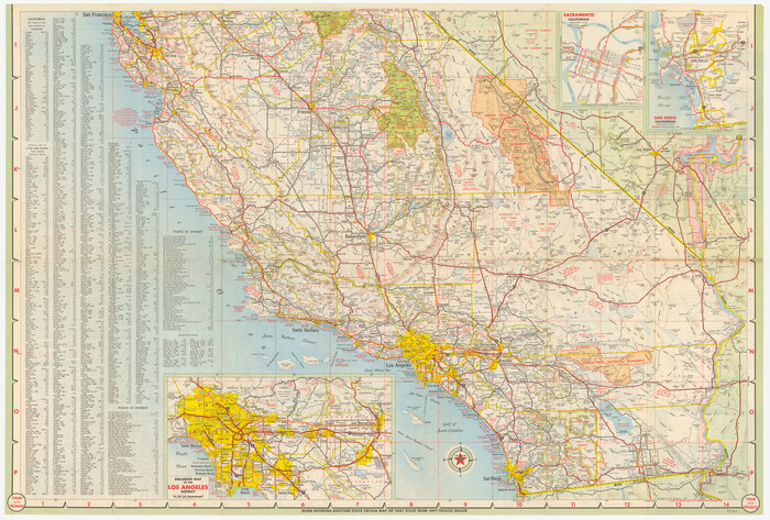
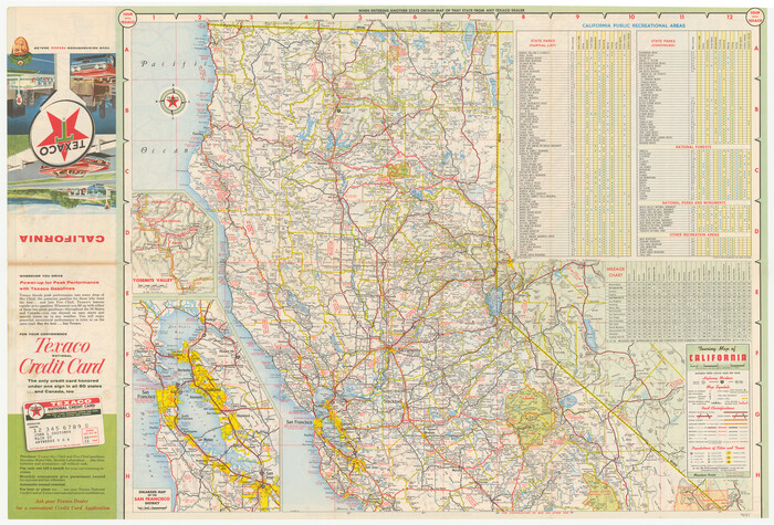
A Map of California with Descriptive Notes

A Map of California with Descriptive Notes
1954
Size: 29.5 x 37.6 inches
92394
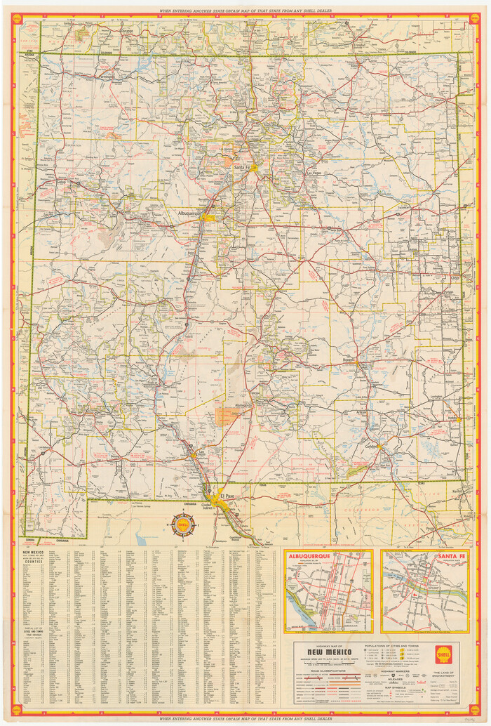
Conoco Official Road Map New Mexico

Print $20.00
- Digital $50.00
Conoco Official Road Map New Mexico
1934
Size: 18.5 x 24.4 inches
92436
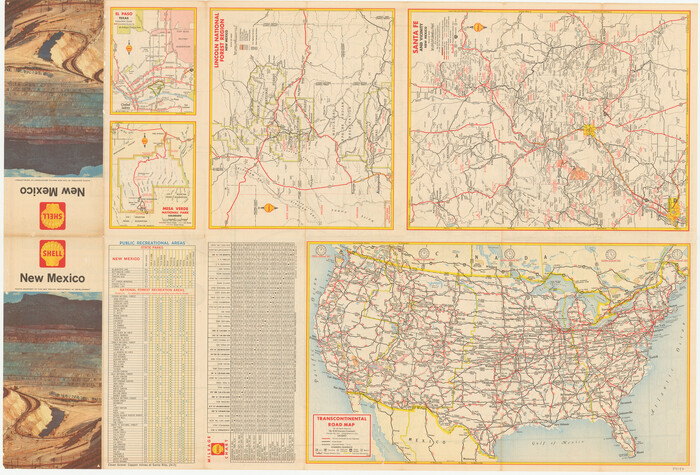
Conoco Official Road Map New Mexico

Print $20.00
- Digital $50.00
Conoco Official Road Map New Mexico
1934
Size: 18.5 x 24.5 inches
92437
Mexico, California and Texas

Print $20.00
- Digital $50.00
Mexico, California and Texas
1851
Size: 11.1 x 14.9 inches
93779
A New Map of Texas, Oregon and California with the regions adjoining, compiled from the most recent authorities

Print $20.00
- Digital $50.00
A New Map of Texas, Oregon and California with the regions adjoining, compiled from the most recent authorities
1846
Size: 23.2 x 21.2 inches
93872
Texas, Oregon and California [Cover and accompaniment]
![93873, Texas, Oregon and California [Cover and accompaniment], Holcomb Digital Map Collection](https://historictexasmaps.com/wmedia_w700/pdf_converted_jpg/qi_pdf_thumbnail_38543.jpg)
Print $108.00
- Digital $50.00
Texas, Oregon and California [Cover and accompaniment]
1846
Size: 5.4 x 3.4 inches
93873
A new map of Texas, Oregon and California with the regions adjoining, compiled from the most recent authorities

Print $20.00
- Digital $50.00
A new map of Texas, Oregon and California with the regions adjoining, compiled from the most recent authorities
1846
Size: 23.7 x 21.8 inches
93940
A New Map of Nebraska, Kansas, New Mexico and Indian Territories

Print $20.00
- Digital $50.00
A New Map of Nebraska, Kansas, New Mexico and Indian Territories
Size: 18.6 x 15.2 inches
93985
Minnesota Route the shortest and best to the Idaho Gold Mines

Print $20.00
- Digital $50.00
Minnesota Route the shortest and best to the Idaho Gold Mines
Size: 21.0 x 46.3 inches
93989
A New Map of Texas, Oregon and California with the regions adjoining, compiled from the most recent authorities

Print $20.00
- Digital $50.00
A New Map of Texas, Oregon and California with the regions adjoining, compiled from the most recent authorities
Size: 22.8 x 20.9 inches
93990
New Map of the Mining Regions of Idaho and Montana showing the geographical positions of the Blackfoot, Owyhee & South Boise Mines and the various routes thereto

Print $20.00
- Digital $50.00
New Map of the Mining Regions of Idaho and Montana showing the geographical positions of the Blackfoot, Owyhee & South Boise Mines and the various routes thereto
Size: 21.9 x 29.4 inches
93991
Outline Map showing a new route from Texas to Fort Yuma, California for cattle droves and trains en route to California

Print $40.00
- Digital $50.00
Outline Map showing a new route from Texas to Fort Yuma, California for cattle droves and trains en route to California
1870
Size: 17.3 x 52.7 inches
94048
Rand, McNally & Co's New Mexico

Print $20.00
- Digital $50.00
Rand, McNally & Co's New Mexico
1880
Size: 21.4 x 14.7 inches
94050
A new map of the states of Texas & California, the territories of Oregon, New Mexico, Utah, and the regions adjacent: compiled from the most recent authorities

Print $20.00
- Digital $50.00
A new map of the states of Texas & California, the territories of Oregon, New Mexico, Utah, and the regions adjacent: compiled from the most recent authorities
1851
Size: 22.4 x 20.4 inches
94051
Morley's Map of New Mexico compiled from the latest government surveys and other reliable sources

Print $20.00
- Digital $50.00
Morley's Map of New Mexico compiled from the latest government surveys and other reliable sources
1873
Size: 26.2 x 28.0 inches
94052
Map of Arizona prepared specially for R.J. Hinton's handbook of Arizona

Print $20.00
- Digital $50.00
Map of Arizona prepared specially for R.J. Hinton's handbook of Arizona
1877
Size: 36.4 x 25.7 inches
94062
Die Eisenbahm von dem Missisippi nach dem stillen Ocean (Californien)

Print $20.00
- Digital $50.00
Die Eisenbahm von dem Missisippi nach dem stillen Ocean (Californien)
1856
Size: 14.0 x 14.8 inches
94075
Map of the Interior of Louisiana with a part of New Mexico

Print $20.00
Map of the Interior of Louisiana with a part of New Mexico
1811
Size: 11.1 x 14.2 inches
94269
Map illustrating the general geological features of the country west of the Mississippi River compiled from the surveys of W.H. Emory and from the Pacific Railroad surveys & other sources

Print $20.00
- Digital $50.00
Map illustrating the general geological features of the country west of the Mississippi River compiled from the surveys of W.H. Emory and from the Pacific Railroad surveys & other sources
1857
Size: 21.2 x 24.7 inches
95172
A New Map of Texas, Oregon, and California with the regions adjoining compiled from the most recent authorities

Print $20.00
- Digital $50.00
A New Map of Texas, Oregon, and California with the regions adjoining compiled from the most recent authorities
1846
Size: 23.0 x 21.2 inches
95748
Territory of New Mexico
Print $20.00
- Digital $50.00
Territory of New Mexico
1896
-
Size
43.4 x 36.5 inches
-
Map/Doc
76177
-
Creation Date
1896
Special Map of the Great Southwest for Burke's Texas Almanac
Print $20.00
Special Map of the Great Southwest for Burke's Texas Almanac
1885
-
Size
42.1 x 28.5 inches
-
Map/Doc
76214
-
Creation Date
1885
Principal Highways of the Southwest with particular reference to New Mexico, Oklahoma, Texas, Arkansas and Louisiana
Print $20.00
Principal Highways of the Southwest with particular reference to New Mexico, Oklahoma, Texas, Arkansas and Louisiana
1933
-
Size
24.3 x 18.4 inches
-
Map/Doc
76302
-
Creation Date
1933
Territory of New Mexico
Print $20.00
- Digital $50.00
Territory of New Mexico
1903
-
Size
23.8 x 19.6 inches
-
Map/Doc
82011
-
Creation Date
1903
Mexico, California and Texas
Print $20.00
Mexico, California and Texas
1850
-
Size
11.1 x 15.0 inches
-
Map/Doc
82964
-
Creation Date
1850
A New Map of Texas, Oregon and California with the Regions adjoining
Print $20.00
- Digital $50.00
A New Map of Texas, Oregon and California with the Regions adjoining
1846
-
Size
20.4 x 19.3 inches
-
Map/Doc
89067
-
Creation Date
1846
A Map of California with Descriptive Notes
A Map of California with Descriptive Notes
1954
-
Size
29.5 x 37.6 inches
-
Map/Doc
92394
-
Creation Date
1954
Conoco Official Road Map New Mexico
Print $20.00
- Digital $50.00
Conoco Official Road Map New Mexico
1934
-
Size
18.5 x 24.4 inches
-
Map/Doc
92436
-
Creation Date
1934
Conoco Official Road Map New Mexico
Print $20.00
- Digital $50.00
Conoco Official Road Map New Mexico
1934
-
Size
18.5 x 24.5 inches
-
Map/Doc
92437
-
Creation Date
1934
Mexico, California and Texas
Print $20.00
- Digital $50.00
Mexico, California and Texas
1851
-
Size
11.1 x 14.9 inches
-
Map/Doc
93779
-
Creation Date
1851
A New Map of Texas, Oregon and California with the regions adjoining, compiled from the most recent authorities
Print $20.00
- Digital $50.00
A New Map of Texas, Oregon and California with the regions adjoining, compiled from the most recent authorities
1846
-
Size
23.2 x 21.2 inches
-
Map/Doc
93872
-
Creation Date
1846
Texas, Oregon and California [Cover and accompaniment]
Print $108.00
- Digital $50.00
Texas, Oregon and California [Cover and accompaniment]
1846
-
Size
5.4 x 3.4 inches
-
Map/Doc
93873
-
Creation Date
1846
A new map of Texas, Oregon and California with the regions adjoining, compiled from the most recent authorities
Print $20.00
- Digital $50.00
A new map of Texas, Oregon and California with the regions adjoining, compiled from the most recent authorities
1846
-
Size
23.7 x 21.8 inches
-
Map/Doc
93940
-
Creation Date
1846
A New Map of Nebraska, Kansas, New Mexico and Indian Territories
Print $20.00
- Digital $50.00
A New Map of Nebraska, Kansas, New Mexico and Indian Territories
-
Size
18.6 x 15.2 inches
-
Map/Doc
93985
Minnesota Route the shortest and best to the Idaho Gold Mines
Print $20.00
- Digital $50.00
Minnesota Route the shortest and best to the Idaho Gold Mines
-
Size
21.0 x 46.3 inches
-
Map/Doc
93989
A New Map of Texas, Oregon and California with the regions adjoining, compiled from the most recent authorities
Print $20.00
- Digital $50.00
A New Map of Texas, Oregon and California with the regions adjoining, compiled from the most recent authorities
-
Size
22.8 x 20.9 inches
-
Map/Doc
93990
New Map of the Mining Regions of Idaho and Montana showing the geographical positions of the Blackfoot, Owyhee & South Boise Mines and the various routes thereto
Print $20.00
- Digital $50.00
New Map of the Mining Regions of Idaho and Montana showing the geographical positions of the Blackfoot, Owyhee & South Boise Mines and the various routes thereto
-
Size
21.9 x 29.4 inches
-
Map/Doc
93991
Outline Map showing a new route from Texas to Fort Yuma, California for cattle droves and trains en route to California
Print $40.00
- Digital $50.00
Outline Map showing a new route from Texas to Fort Yuma, California for cattle droves and trains en route to California
1870
-
Size
17.3 x 52.7 inches
-
Map/Doc
94048
-
Creation Date
1870
Rand, McNally & Co's New Mexico
Print $20.00
- Digital $50.00
Rand, McNally & Co's New Mexico
1880
-
Size
21.4 x 14.7 inches
-
Map/Doc
94050
-
Creation Date
1880
A new map of the states of Texas & California, the territories of Oregon, New Mexico, Utah, and the regions adjacent: compiled from the most recent authorities
Print $20.00
- Digital $50.00
A new map of the states of Texas & California, the territories of Oregon, New Mexico, Utah, and the regions adjacent: compiled from the most recent authorities
1851
-
Size
22.4 x 20.4 inches
-
Map/Doc
94051
-
Creation Date
1851
Morley's Map of New Mexico compiled from the latest government surveys and other reliable sources
Print $20.00
- Digital $50.00
Morley's Map of New Mexico compiled from the latest government surveys and other reliable sources
1873
-
Size
26.2 x 28.0 inches
-
Map/Doc
94052
-
Creation Date
1873
Map of Arizona prepared specially for R.J. Hinton's handbook of Arizona
Print $20.00
- Digital $50.00
Map of Arizona prepared specially for R.J. Hinton's handbook of Arizona
1877
-
Size
36.4 x 25.7 inches
-
Map/Doc
94062
-
Creation Date
1877
Die Eisenbahm von dem Missisippi nach dem stillen Ocean (Californien)
Print $20.00
- Digital $50.00
Die Eisenbahm von dem Missisippi nach dem stillen Ocean (Californien)
1856
-
Size
14.0 x 14.8 inches
-
Map/Doc
94075
-
Creation Date
1856
Map of the Interior of Louisiana with a part of New Mexico
Print $20.00
Map of the Interior of Louisiana with a part of New Mexico
1811
-
Size
11.1 x 14.2 inches
-
Map/Doc
94269
-
Creation Date
1811
Map illustrating the general geological features of the country west of the Mississippi River compiled from the surveys of W.H. Emory and from the Pacific Railroad surveys & other sources
Print $20.00
- Digital $50.00
Map illustrating the general geological features of the country west of the Mississippi River compiled from the surveys of W.H. Emory and from the Pacific Railroad surveys & other sources
1857
-
Size
21.2 x 24.7 inches
-
Map/Doc
95172
-
Creation Date
1857
A New Map of Texas, Oregon, and California with the regions adjoining compiled from the most recent authorities
Print $20.00
- Digital $50.00
A New Map of Texas, Oregon, and California with the regions adjoining compiled from the most recent authorities
1846
-
Size
23.0 x 21.2 inches
-
Map/Doc
95748
-
Creation Date
1846