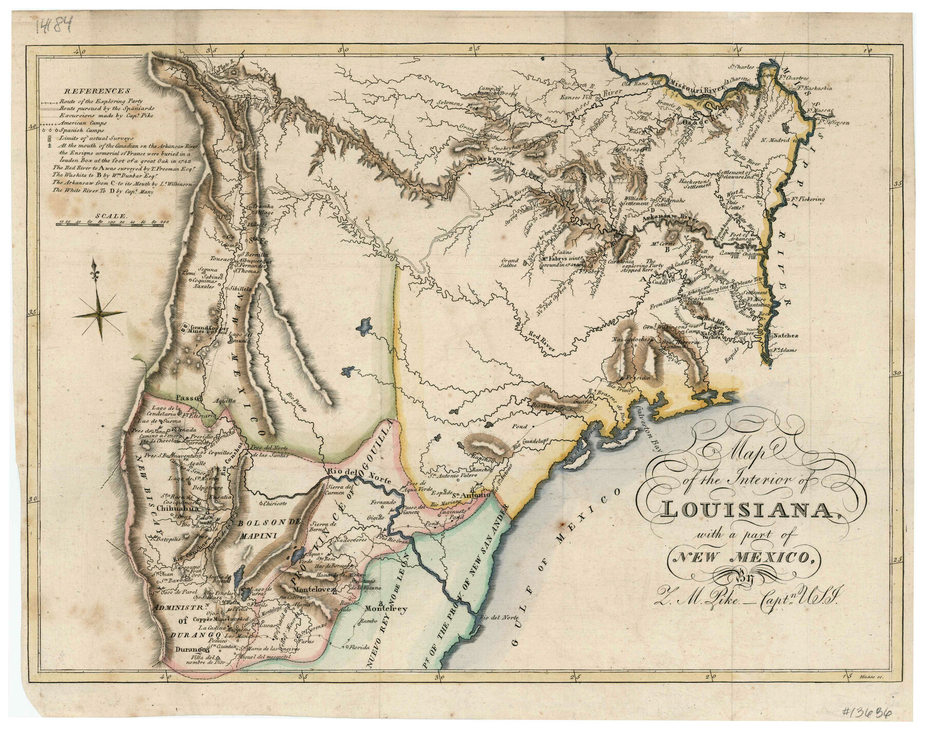
Map of the Interior of Louisiana with a part of New Mexico
-
Map/Doc
94269
-
Collection
Non-GLO Digital Images
-
Object Dates
[1811] (Creation Date)
-
People and Organizations
Z.M. Pike (Author)
-
Subjects
New Southwest Old Southwest
-
Height x Width
11.1 x 14.2 inches
28.2 x 36.1 cm
-
Medium
digital image
-
Comments
Digital image courtesy of William G. Price.
Part of: Non-GLO Digital Images
A New Map of ye North Parts of America according to the division thereof by the Articles of Peace in 1763

Print $20.00
A New Map of ye North Parts of America according to the division thereof by the Articles of Peace in 1763
1763
Size 8.5 x 11.3 inches
Map/Doc 95280
Bird's Eye View of Gatesville, Coryell County, Texas

Print $20.00
Bird's Eye View of Gatesville, Coryell County, Texas
1884
Size 15.7 x 24.2 inches
Map/Doc 89088
Bird's Eye View of San Marcos, Hays County, Texas

Print $20.00
Bird's Eye View of San Marcos, Hays County, Texas
1881
Size 18.5 x 28.3 inches
Map/Doc 89205

Railroad Commissioner's Map of Texas

Print $20.00
Railroad Commissioner's Map of Texas
1897
Size 27.0 x 23.0 inches
Map/Doc 90070
Map of the State of Texas Engraved to Illustrate Mitchell's School and Family Geography

Print $20.00
Map of the State of Texas Engraved to Illustrate Mitchell's School and Family Geography
1846
Size 12.0 x 9.6 inches
Map/Doc 87902

[Movements & Objectives of the 143rd & 144th Infantry on October 12-13, 1918]
![94135, [Movements & Objectives of the 143rd & 144th Infantry on October 12-13, 1918], Non-GLO Digital Images](https://historictexasmaps.com/wmedia_w700/maps/94135-1.tif.jpg)
Print $20.00
[Movements & Objectives of the 143rd & 144th Infantry on October 12-13, 1918]
1918
Size 42.4 x 30.0 inches
Map/Doc 94135
Bird's Eye View of the City of Belton, Bell County, Texas

Print $20.00
Bird's Eye View of the City of Belton, Bell County, Texas
1881
Size 18.5 x 23.8 inches
Map/Doc 89074
Gulf States and Arkansas

Print $20.00
Gulf States and Arkansas
1874
Size 9.4 x 12.0 inches
Map/Doc 95285

Plano de la Sauteña. Indicando los terrenos irrigados en Texas

Plano de la Sauteña. Indicando los terrenos irrigados en Texas
Size 38.6 x 37.8 inches
Map/Doc 94566
You may also like
Presidio County Rolled Sketch 91

Print $20.00
- Digital $50.00
Presidio County Rolled Sketch 91
Size 15.1 x 29.4 inches
Map/Doc 7376
Fannin County

Print $20.00
- Digital $50.00
Fannin County
1946
Size 42.3 x 37.4 inches
Map/Doc 73145
Flight Mission No. BRA-16M, Frame 166, Jefferson County

Print $20.00
- Digital $50.00
Flight Mission No. BRA-16M, Frame 166, Jefferson County
1953
Size 18.5 x 22.3 inches
Map/Doc 85764
[H. & G. N. Block 1]
![90945, [H. & G. N. Block 1], Twichell Survey Records](https://historictexasmaps.com/wmedia_w700/maps/90945-1.tif.jpg)
Print $20.00
- Digital $50.00
[H. & G. N. Block 1]
1873
Size 17.4 x 14.1 inches
Map/Doc 90945
New Hobbs, Lea County, New Mexico

Print $20.00
- Digital $50.00
New Hobbs, Lea County, New Mexico
Size 15.7 x 20.1 inches
Map/Doc 92424

Carta geográfica que comprende en su extensión mucha parte del arzobispado de México, y alguna de los obispados de Puebla, Valladolid de Michoacán, Guadalajara y Durango, confinantes entre si

Carta geográfica que comprende en su extensión mucha parte del arzobispado de México, y alguna de los obispados de Puebla, Valladolid de Michoacán, Guadalajara y Durango, confinantes entre si
1779
Size 33.9 x 22.0 inches
Map/Doc 97079
Flight Mission No. CUG-3P, Frame 142, Kleberg County

Print $20.00
- Digital $50.00
Flight Mission No. CUG-3P, Frame 142, Kleberg County
1956
Size 18.7 x 22.3 inches
Map/Doc 86277
Zavala County Boundary File 4

Print $42.00
- Digital $50.00
Zavala County Boundary File 4
Size 9.2 x 7.9 inches
Map/Doc 60271
Martin County Sketch File 4

Print $20.00
- Digital $50.00
Martin County Sketch File 4
Size 26.9 x 19.8 inches
Map/Doc 12027
Erath County Working Sketch 18

Print $20.00
- Digital $50.00
Erath County Working Sketch 18
1962
Size 30.5 x 34.8 inches
Map/Doc 69099
Connected Map of Austin's Colony

Print $20.00
- Digital $50.00
Connected Map of Austin's Colony
1892
Size 47.3 x 43.3 inches
Map/Doc 76075