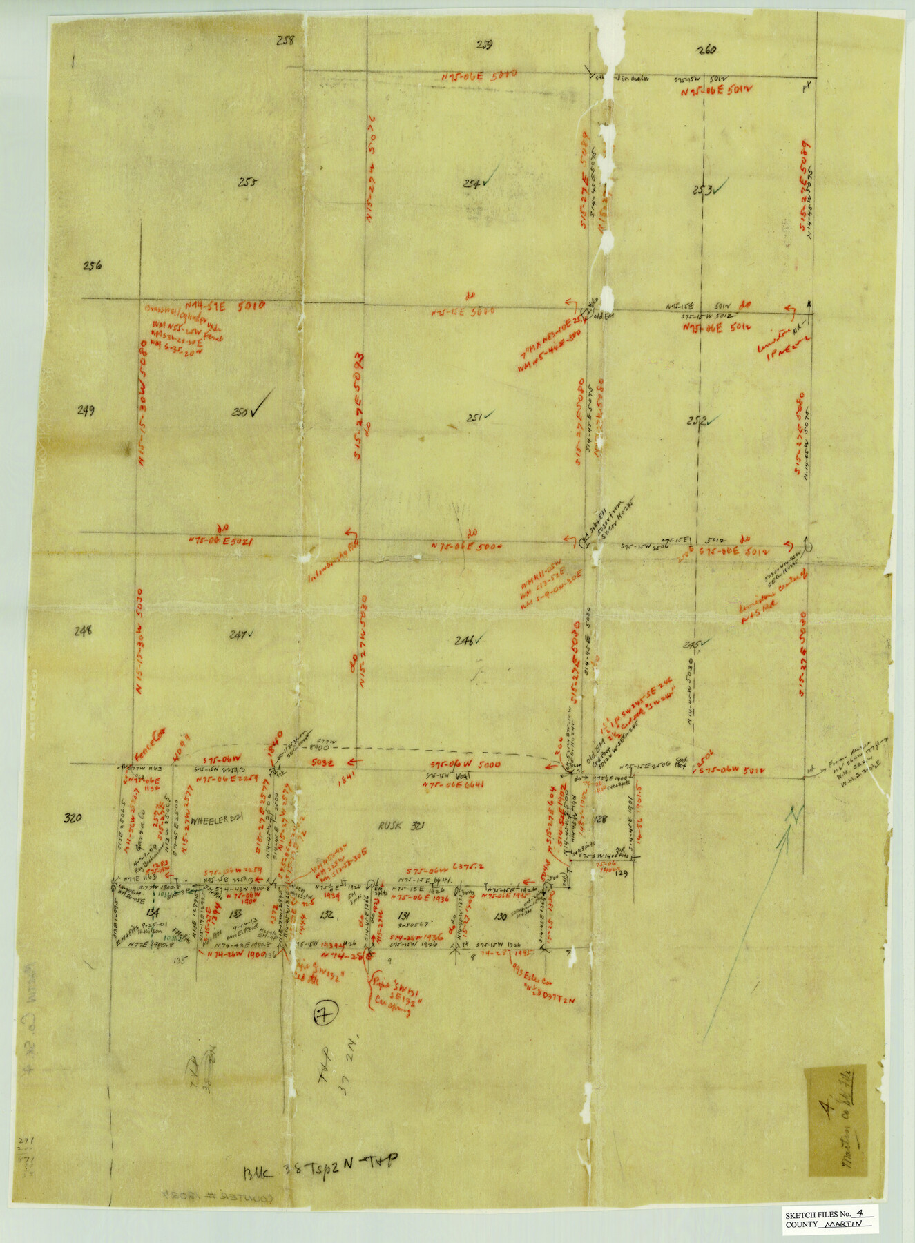
Martin County Sketch File 4
[School Land Leagues and parts of Block A]
-
Map/Doc
12027
-
Collection
General Map Collection
-
Counties
Martin
-
Subjects
Surveying Sketch File
-
Height x Width
26.9 x 19.8 inches
68.3 x 50.3 cm
-
Medium
paper, manuscript
Part of: General Map Collection
Throckmorton County Sketch File 5

Print $58.00
- Digital $50.00
Throckmorton County Sketch File 5
Size 14.4 x 8.7 inches
Map/Doc 38056
Leon County Sketch File 11

Print $4.00
- Digital $50.00
Leon County Sketch File 11
1858
Size 10.1 x 8.0 inches
Map/Doc 29761
Young County Working Sketch 26

Print $20.00
- Digital $50.00
Young County Working Sketch 26
1982
Size 25.4 x 22.9 inches
Map/Doc 62049
Flight Mission No. DQO-8K, Frame 8, Galveston County

Print $20.00
- Digital $50.00
Flight Mission No. DQO-8K, Frame 8, Galveston County
1952
Size 18.8 x 22.5 inches
Map/Doc 85131
Flight Mission No. DIX-8P, Frame 90, Aransas County

Print $20.00
- Digital $50.00
Flight Mission No. DIX-8P, Frame 90, Aransas County
1956
Size 18.6 x 22.4 inches
Map/Doc 83915
Live Oak County Rolled Sketch 10A

Print $20.00
- Digital $50.00
Live Oak County Rolled Sketch 10A
1983
Size 38.4 x 43.6 inches
Map/Doc 9457
Flight Mission No. DAG-17K, Frame 79, Matagorda County

Print $20.00
- Digital $50.00
Flight Mission No. DAG-17K, Frame 79, Matagorda County
1952
Size 19.7 x 25.0 inches
Map/Doc 86338
Hays County Sketch File 13a

Print $40.00
- Digital $50.00
Hays County Sketch File 13a
Size 12.3 x 15.0 inches
Map/Doc 26223
Hansford County Boundary File 2a

Print $40.00
- Digital $50.00
Hansford County Boundary File 2a
Size 14.2 x 8.7 inches
Map/Doc 54252
Nueces County Rolled Sketch 113A

Print $20.00
- Digital $50.00
Nueces County Rolled Sketch 113A
1972
Size 18.6 x 23.3 inches
Map/Doc 7122
Bastrop County Working Sketch Graphic Index

Print $40.00
- Digital $50.00
Bastrop County Working Sketch Graphic Index
1955
Size 49.6 x 40.9 inches
Map/Doc 76462
Flight Mission No. BRE-1P, Frame 99, Nueces County

Print $20.00
- Digital $50.00
Flight Mission No. BRE-1P, Frame 99, Nueces County
1956
Size 18.4 x 22.2 inches
Map/Doc 86670
You may also like
Henderson County Working Sketch 7

Print $20.00
- Digital $50.00
Henderson County Working Sketch 7
1922
Size 12.5 x 18.8 inches
Map/Doc 66140
General Highway Map, Crosby County, Texas

Print $20.00
- Digital $50.00
General Highway Map, Crosby County, Texas
1950
Size 25.7 x 18.8 inches
Map/Doc 92596
McCulloch County Sketch File 1

Print $4.00
- Digital $50.00
McCulloch County Sketch File 1
1854
Size 8.7 x 6.8 inches
Map/Doc 31165
[Victoria District]
![1945, [Victoria District], General Map Collection](https://historictexasmaps.com/wmedia_w700/maps/1945.tif.jpg)
Print $20.00
- Digital $50.00
[Victoria District]
Size 34.8 x 25.6 inches
Map/Doc 1945
Maps of Gulf Intracoastal Waterway, Texas - Sabine River to the Rio Grande and connecting waterways including ship channels

Print $20.00
- Digital $50.00
Maps of Gulf Intracoastal Waterway, Texas - Sabine River to the Rio Grande and connecting waterways including ship channels
1966
Size 14.6 x 22.3 inches
Map/Doc 61938
Dickens County Sketch File 9

Print $4.00
- Digital $50.00
Dickens County Sketch File 9
Size 21.6 x 20.9 inches
Map/Doc 11319
Leon County Sketch File 12

Print $23.00
- Digital $50.00
Leon County Sketch File 12
1886
Size 9.5 x 11.5 inches
Map/Doc 29765
Flight Mission No. DCL-7C, Frame 111, Kenedy County

Print $20.00
- Digital $50.00
Flight Mission No. DCL-7C, Frame 111, Kenedy County
1943
Size 18.5 x 22.3 inches
Map/Doc 86076
Galveston County Sketch File 73g

Print $20.00
- Digital $50.00
Galveston County Sketch File 73g
Size 32.1 x 41.2 inches
Map/Doc 10460
Jefferson County Rolled Sketch 64

Print $20.00
- Digital $50.00
Jefferson County Rolled Sketch 64
1982
Size 26.7 x 37.4 inches
Map/Doc 9319
El Paso County Sketch File 26

Print $20.00
- Digital $50.00
El Paso County Sketch File 26
Size 24.8 x 21.9 inches
Map/Doc 11457
Harris County Working Sketch 117

Print $20.00
- Digital $50.00
Harris County Working Sketch 117
1984
Size 28.2 x 25.5 inches
Map/Doc 66009