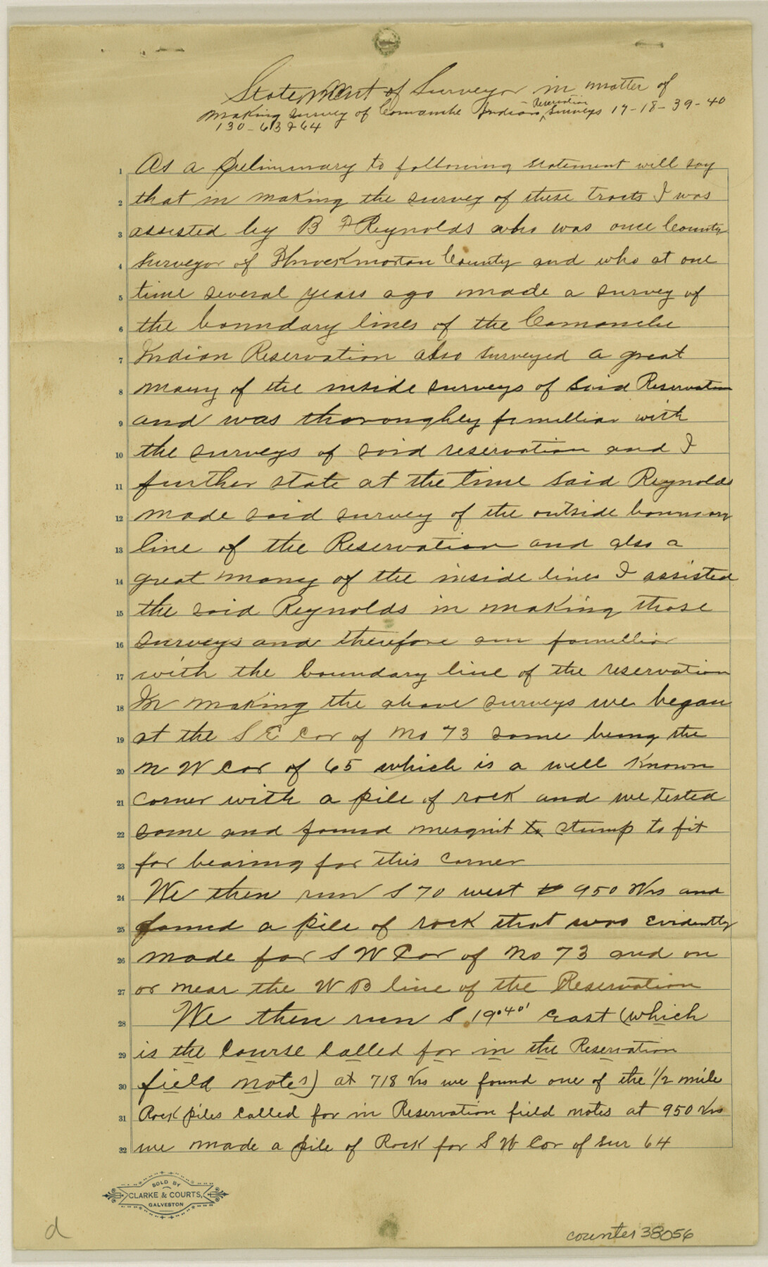
Throckmorton County Sketch File 5
Indian Reserve, Throckmorton County, Texas
-
Map/Doc
38056
-
Collection
General Map Collection
-
Object Dates
12/29/1902 (Survey Date)
7/18/1898 (Survey Date)
7/21/1898 (File Date)
9/30/1898 (Correspondence Date)
1/18/1882 (File Date)
1/14/1882 (Correspondence Date)
-
People and Organizations
Sundry (Surveyor/Engineer)
B.F. Reynolds (Surveyor/Engineer)
Stribling (Surveyor/Engineer)
J.F. Lindsey (Surveyor/Engineer)
S.H. Butler (Surveyor/Engineer)
-
Counties
Throckmorton
-
Subjects
Surveying Sketch File
-
Height x Width
14.4 x 8.7 inches
36.6 x 22.1 cm
-
Medium
paper, manuscript
-
Features
Comanche Indian Reservation
Clear Fork [of Brazos River]
California Road
Ranger Creek
Techumseh Creek
Sibley Creek
Part of: General Map Collection
Burnet County Sketch File 7

Print $6.00
- Digital $50.00
Burnet County Sketch File 7
1854
Size 7.1 x 8.1 inches
Map/Doc 16686
Shelby County Rolled Sketch 14

Print $20.00
- Digital $50.00
Shelby County Rolled Sketch 14
1948
Size 33.1 x 25.9 inches
Map/Doc 7782
Yoakum County

Print $20.00
- Digital $50.00
Yoakum County
1932
Size 47.1 x 35.6 inches
Map/Doc 63139
Sketch of coast of Texas, Laguna Madre from Pt. of Rocks to Corpus Christi [and accompanying letter]
![72964, Sketch of coast of Texas, Laguna Madre from Pt. of Rocks to Corpus Christi [and accompanying letter], General Map Collection](https://historictexasmaps.com/wmedia_w700/maps/72964.tif.jpg)
Print $2.00
- Digital $50.00
Sketch of coast of Texas, Laguna Madre from Pt. of Rocks to Corpus Christi [and accompanying letter]
Size 11.2 x 8.8 inches
Map/Doc 72964

Jeff Davis County Sketch File 28

Print $30.00
- Digital $50.00
Jeff Davis County Sketch File 28
1916
Size 7.2 x 8.7 inches
Map/Doc 28003
Colton's Map of the United States of America

Print $20.00
- Digital $50.00
Colton's Map of the United States of America
1866
Size 21.3 x 36.7 inches
Map/Doc 93642
Pecos County Rolled Sketch 22

Print $40.00
- Digital $50.00
Pecos County Rolled Sketch 22
1886
Size 73.4 x 45.2 inches
Map/Doc 93461
Kinney County Sketch File 38

Print $8.00
- Digital $50.00
Kinney County Sketch File 38
1882
Size 14.3 x 8.7 inches
Map/Doc 29188
Stonewall County Rolled Sketch 24B

Print $40.00
- Digital $50.00
Stonewall County Rolled Sketch 24B
1954
Size 50.1 x 43.1 inches
Map/Doc 9964
Texas Official Travel Map [Major Metropolitan Areas]
![96830, Texas Official Travel Map [Major Metropolitan Areas], General Map Collection](https://historictexasmaps.com/wmedia_w700/maps/96830.tif.jpg)
Texas Official Travel Map [Major Metropolitan Areas]
2008
Size 33.2 x 36.1 inches
Map/Doc 96830
Flight Mission No. CUG-1P, Frame 104, Kleberg County

Print $20.00
- Digital $50.00
Flight Mission No. CUG-1P, Frame 104, Kleberg County
1956
Size 18.5 x 21.1 inches
Map/Doc 86154
You may also like
[T. & P. Blocks 31-33, Township 5N]
![90568, [T. & P. Blocks 31-33, Township 5N], Twichell Survey Records](https://historictexasmaps.com/wmedia_w700/maps/90568-1.tif.jpg)
Print $20.00
- Digital $50.00
[T. & P. Blocks 31-33, Township 5N]
Size 14.6 x 17.7 inches
Map/Doc 90568
[Sketch Showing Blocks O18 and B11]
![93108, [Sketch Showing Blocks O18 and B11], Twichell Survey Records](https://historictexasmaps.com/wmedia_w700/maps/93108-1.tif.jpg)
Print $3.00
- Digital $50.00
[Sketch Showing Blocks O18 and B11]
Size 15.5 x 11.9 inches
Map/Doc 93108
Flight Mission No. CRE-2R, Frame 89, Jackson County

Print $20.00
- Digital $50.00
Flight Mission No. CRE-2R, Frame 89, Jackson County
1956
Size 18.6 x 22.2 inches
Map/Doc 85361
Edwards County Rolled Sketch 21

Print $20.00
- Digital $50.00
Edwards County Rolled Sketch 21
1948
Size 17.0 x 29.4 inches
Map/Doc 5809
Uvalde County Rolled Sketch 5

Print $20.00
- Digital $50.00
Uvalde County Rolled Sketch 5
Size 38.0 x 42.6 inches
Map/Doc 10063
Harris County Rolled Sketch 44

Print $20.00
- Digital $50.00
Harris County Rolled Sketch 44
Size 22.5 x 29.9 inches
Map/Doc 6102
Bailey County Sketch File 19

Print $8.00
- Digital $50.00
Bailey County Sketch File 19
1882
Size 13.2 x 8.4 inches
Map/Doc 13987
Garza County Working Sketch 16

Print $20.00
- Digital $50.00
Garza County Working Sketch 16
1994
Size 21.7 x 40.3 inches
Map/Doc 63163
PSL Field Notes for Blocks A42 through A55 in Andrews County

PSL Field Notes for Blocks A42 through A55 in Andrews County
Map/Doc 81644
Henderson County Sketch File 4

Print $4.00
- Digital $50.00
Henderson County Sketch File 4
1851
Size 12.9 x 8.3 inches
Map/Doc 26323
Flight Mission No. CRC-1R, Frame 93, Chambers County

Print $20.00
- Digital $50.00
Flight Mission No. CRC-1R, Frame 93, Chambers County
1956
Size 18.7 x 22.6 inches
Map/Doc 84708
Duval County Sketch File 52

Print $20.00
- Digital $50.00
Duval County Sketch File 52
1936
Size 21.0 x 28.6 inches
Map/Doc 11402