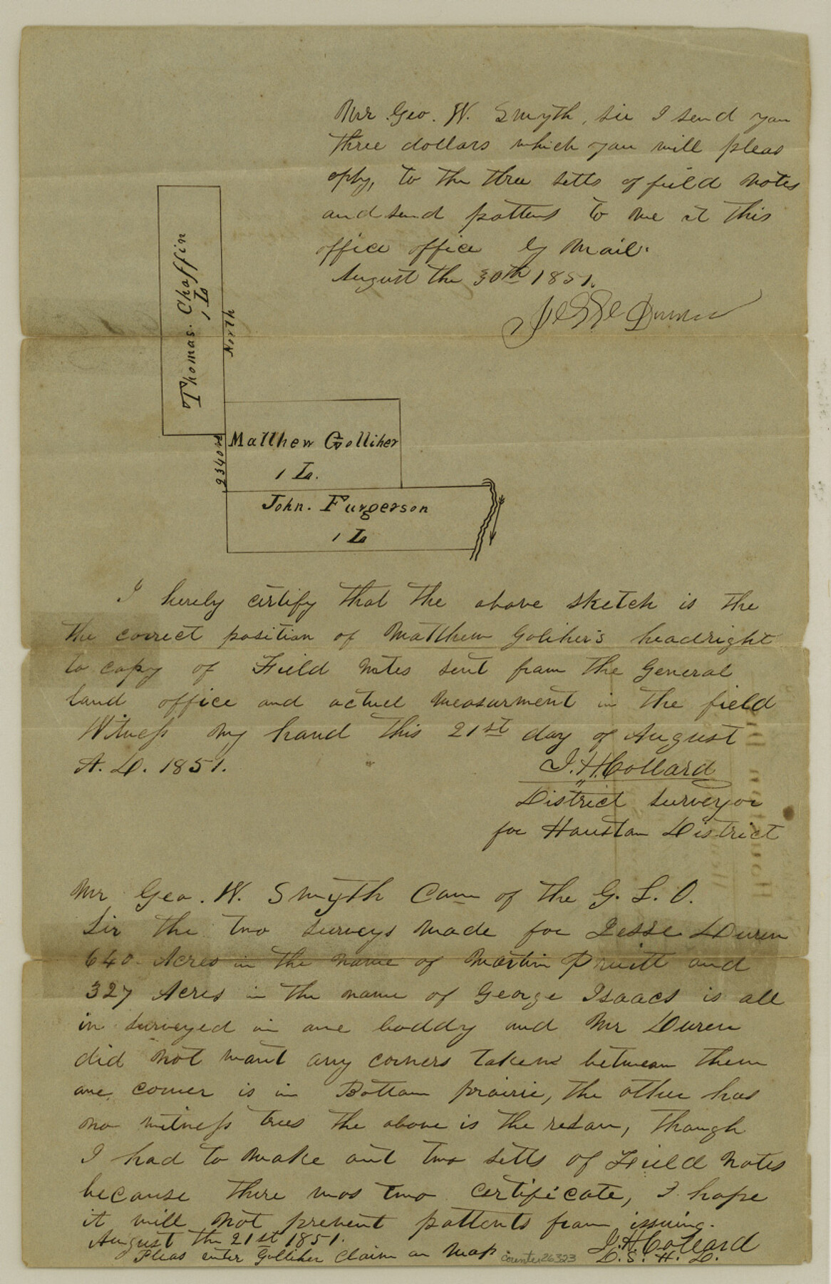
Henderson County Sketch File 4
[Connection of a league titled to Mathew Golcher]
-
Map/Doc
26323
-
Collection
General Map Collection
-
Object Dates
8/21/1851 (Creation Date)
9/12/1851 (File Date)
-
People and Organizations
J.H. Collard (Surveyor/Engineer)
-
Counties
Henderson Anderson
-
Subjects
Surveying Sketch File
-
Height x Width
12.9 x 8.3 inches
32.8 x 21.1 cm
-
Medium
paper, manuscript
Part of: General Map Collection
Gregg County Boundary File 1

Print $6.00
- Digital $50.00
Gregg County Boundary File 1
Size 10.0 x 7.9 inches
Map/Doc 53981
Jack County Working Sketch 21

Print $20.00
- Digital $50.00
Jack County Working Sketch 21
1993
Size 28.3 x 40.0 inches
Map/Doc 66447
Edwards County Working Sketch 93

Print $20.00
- Digital $50.00
Edwards County Working Sketch 93
1966
Size 30.7 x 35.7 inches
Map/Doc 68969
Harris County Working Sketch 100

Print $20.00
- Digital $50.00
Harris County Working Sketch 100
1979
Size 29.9 x 31.3 inches
Map/Doc 65992
Kimble County Working Sketch 3

Print $20.00
- Digital $50.00
Kimble County Working Sketch 3
1897
Size 16.4 x 21.4 inches
Map/Doc 70071
Val Verde County Sketch File Z14

Print $20.00
- Digital $50.00
Val Verde County Sketch File Z14
1899
Size 22.1 x 20.6 inches
Map/Doc 12556
Fort Bend County Working Sketch 21

Print $20.00
- Digital $50.00
Fort Bend County Working Sketch 21
Size 26.9 x 28.6 inches
Map/Doc 69227
Hudspeth County Rolled Sketch 46

Print $40.00
- Digital $50.00
Hudspeth County Rolled Sketch 46
Size 10.2 x 128.3 inches
Map/Doc 76039
[Sketch for Mineral Application 13439 - Old River, Walle Merritt]
![65688, [Sketch for Mineral Application 13439 - Old River, Walle Merritt], General Map Collection](https://historictexasmaps.com/wmedia_w700/maps/65688-1.tif.jpg)
Print $20.00
- Digital $50.00
[Sketch for Mineral Application 13439 - Old River, Walle Merritt]
1925
Size 41.2 x 18.9 inches
Map/Doc 65688
Map of Hays Co.

Print $20.00
- Digital $50.00
Map of Hays Co.
1902
Size 46.5 x 40.7 inches
Map/Doc 4679
Bee County Working Sketch 4

Print $20.00
- Digital $50.00
Bee County Working Sketch 4
1930
Size 18.5 x 16.5 inches
Map/Doc 67254
Freestone County Rolled Sketch 11

Print $20.00
- Digital $50.00
Freestone County Rolled Sketch 11
1934
Size 17.9 x 34.1 inches
Map/Doc 5911
You may also like
University of Texas Land Survey Isogonic Chart and Graph of Meridian Changes on University Lands Principally in Andrews County, Texas

Print $20.00
- Digital $50.00
University of Texas Land Survey Isogonic Chart and Graph of Meridian Changes on University Lands Principally in Andrews County, Texas
Size 15.0 x 18.4 inches
Map/Doc 62947
Brazoria County Rolled Sketch 38

Print $20.00
- Digital $50.00
Brazoria County Rolled Sketch 38
1949
Size 44.6 x 39.5 inches
Map/Doc 8460
Hunt County Sketch File 34

Print $6.00
- Digital $50.00
Hunt County Sketch File 34
Size 9.9 x 7.2 inches
Map/Doc 27143
Comanche County Working Sketch 21

Print $20.00
- Digital $50.00
Comanche County Working Sketch 21
1973
Size 28.0 x 26.1 inches
Map/Doc 68155
Jefferson County, Texas

Print $20.00
- Digital $50.00
Jefferson County, Texas
1879
Size 21.7 x 18.8 inches
Map/Doc 521
Bandera County Working Sketch 17

Print $20.00
- Digital $50.00
Bandera County Working Sketch 17
1943
Size 21.2 x 27.5 inches
Map/Doc 67613
Flight Mission No. BRE-2P, Frame 67, Nueces County

Print $20.00
- Digital $50.00
Flight Mission No. BRE-2P, Frame 67, Nueces County
1956
Size 18.5 x 22.3 inches
Map/Doc 86762
Part of a map showing resurvey of Capitol Leagues by R. S. Hunnicutt & Behn Cook State Surveyors

Print $20.00
- Digital $50.00
Part of a map showing resurvey of Capitol Leagues by R. S. Hunnicutt & Behn Cook State Surveyors
Size 22.2 x 17.6 inches
Map/Doc 90276
Zavala County Working Sketch 24

Print $40.00
- Digital $50.00
Zavala County Working Sketch 24
1980
Size 75.6 x 42.8 inches
Map/Doc 62099
[Movements & Objectives of the 143rd & 144th Infantry on October 12-13, 1918] - Verso
![94136, [Movements & Objectives of the 143rd & 144th Infantry on October 12-13, 1918] - Verso, Non-GLO Digital Images](https://historictexasmaps.com/wmedia_w700/maps/94136-1.tif.jpg)
Print $20.00
[Movements & Objectives of the 143rd & 144th Infantry on October 12-13, 1918] - Verso
1918
Size 42.4 x 30.0 inches
Map/Doc 94136
Leila Y. Post Montgomery & Marjorie Post Hutton's Subdivision of Hall County School Leagues 158-159-N 1/2 157, Cochran County, Texas

Print $20.00
- Digital $50.00
Leila Y. Post Montgomery & Marjorie Post Hutton's Subdivision of Hall County School Leagues 158-159-N 1/2 157, Cochran County, Texas
Size 13.2 x 27.6 inches
Map/Doc 90297
Reeves County Working Sketch 36

Print $20.00
- Digital $50.00
Reeves County Working Sketch 36
1970
Size 43.1 x 35.0 inches
Map/Doc 63479