Anderson County Sketch File 22

Print $40.00
- Digital $50.00
Anderson County Sketch File 22
1925
Size: 38.0 x 37.5 inches
10315
Anderson County Sketch File 25

Print $40.00
- Digital $50.00
Anderson County Sketch File 25
1969
Size: 40.9 x 21.9 inches
10316
Anderson County Sketch File 15

Print $40.00
- Digital $50.00
Anderson County Sketch File 15
1849
Size: 13.6 x 15.6 inches
10800
Anderson County Sketch File 18

Print $40.00
- Digital $50.00
Anderson County Sketch File 18
1880
Size: 16.0 x 13.5 inches
10801
Anderson County Sketch File 19

Print $40.00
- Digital $50.00
Anderson County Sketch File 19
Size: 18.2 x 15.9 inches
10802
Anderson County Sketch File 24

Print $60.00
- Digital $50.00
Anderson County Sketch File 24
1942
Size: 13.2 x 18.2 inches
10803
Anderson County Sketch File 26

Print $40.00
- Digital $50.00
Anderson County Sketch File 26
1954
Size: 22.7 x 17.4 inches
10805
Anderson County Sketch File 27

Print $40.00
- Digital $50.00
Anderson County Sketch File 27
1970
Size: 19.5 x 23.7 inches
10806
Henderson County Sketch File 18

Print $20.00
- Digital $50.00
Henderson County Sketch File 18
1936
Size: 16.7 x 18.3 inches
11756
Henderson County Sketch File 21

Print $20.00
- Digital $50.00
Henderson County Sketch File 21
1941
Size: 27.8 x 17.9 inches
11758
[Jose Pineda grant]
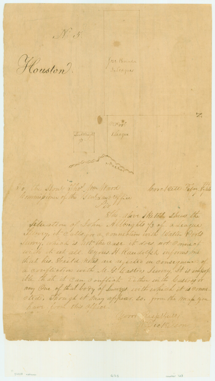
Print $2.00
- Digital $50.00
[Jose Pineda grant]
1846
Size: 13.6 x 7.7 inches
123
Anderson County Sketch File 1

Print $4.00
- Digital $50.00
Anderson County Sketch File 1
1845
Size: 12.5 x 8.3 inches
12737
Anderson County Sketch File 2

Print $4.00
- Digital $50.00
Anderson County Sketch File 2
1847
Size: 12.6 x 8.2 inches
12739
Anderson County Sketch File 3

Print $4.00
- Digital $50.00
Anderson County Sketch File 3
1856
Size: 12.7 x 8.2 inches
12741
Anderson County Sketch File 4

Print $6.00
- Digital $50.00
Anderson County Sketch File 4
Size: 8.7 x 6.4 inches
12743
Anderson County Sketch File 4a

Print $9.00
- Digital $50.00
Anderson County Sketch File 4a
1849
Size: 9.5 x 12.0 inches
12746
Anderson County Sketch File 5

Print $6.00
- Digital $50.00
Anderson County Sketch File 5
1856
Size: 9.7 x 7.8 inches
12750
Anderson County Sketch File 6

Print $4.00
- Digital $50.00
Anderson County Sketch File 6
Size: 12.5 x 8.2 inches
12753
Anderson County Sketch File 6a

Print $4.00
- Digital $50.00
Anderson County Sketch File 6a
1848
Size: 12.6 x 7.5 inches
12755
Anderson County Sketch File 7

Print $4.00
- Digital $50.00
Anderson County Sketch File 7
Size: 7.9 x 10.0 inches
12757
Anderson County Sketch File 8

Print $4.00
- Digital $50.00
Anderson County Sketch File 8
1848
Size: 5.8 x 8.0 inches
12759
Anderson County Sketch File 9

Print $8.00
- Digital $50.00
Anderson County Sketch File 9
Size: 12.5 x 8.2 inches
12761
Anderson County Sketch File 11

Print $6.00
- Digital $50.00
Anderson County Sketch File 11
1853
Size: 8.7 x 6.6 inches
12765
Anderson County Sketch File 11a

Print $6.00
- Digital $50.00
Anderson County Sketch File 11a
1854
Size: 8.2 x 8.2 inches
12768
Anderson County Sketch File 12

Print $6.00
- Digital $50.00
Anderson County Sketch File 12
1852
Size: 13.7 x 8.3 inches
12771
Anderson County Sketch File 13

Print $10.00
- Digital $50.00
Anderson County Sketch File 13
1856
Size: 8.1 x 8.3 inches
12774
Anderson County Sketch File 14

Print $4.00
- Digital $50.00
Anderson County Sketch File 14
1857
Size: 12.7 x 8.0 inches
12779
Anderson County Sketch File 15a

Print $4.00
- Digital $50.00
Anderson County Sketch File 15a
1859
Size: 14.5 x 8.0 inches
12781
Anderson County Sketch File 16

Print $6.00
- Digital $50.00
Anderson County Sketch File 16
1849
Size: 8.6 x 6.5 inches
12783
Anderson County Sketch File 16a

Print $4.00
- Digital $50.00
Anderson County Sketch File 16a
1853
Size: 12.3 x 8.3 inches
12786
Anderson County Sketch File 22
Print $40.00
- Digital $50.00
Anderson County Sketch File 22
1925
-
Size
38.0 x 37.5 inches
-
Map/Doc
10315
-
Creation Date
1925
Anderson County Sketch File 25
Print $40.00
- Digital $50.00
Anderson County Sketch File 25
1969
-
Size
40.9 x 21.9 inches
-
Map/Doc
10316
-
Creation Date
1969
Anderson County Sketch File 15
Print $40.00
- Digital $50.00
Anderson County Sketch File 15
1849
-
Size
13.6 x 15.6 inches
-
Map/Doc
10800
-
Creation Date
1849
Anderson County Sketch File 18
Print $40.00
- Digital $50.00
Anderson County Sketch File 18
1880
-
Size
16.0 x 13.5 inches
-
Map/Doc
10801
-
Creation Date
1880
Anderson County Sketch File 19
Print $40.00
- Digital $50.00
Anderson County Sketch File 19
-
Size
18.2 x 15.9 inches
-
Map/Doc
10802
Anderson County Sketch File 24
Print $60.00
- Digital $50.00
Anderson County Sketch File 24
1942
-
Size
13.2 x 18.2 inches
-
Map/Doc
10803
-
Creation Date
1942
Anderson County Sketch File 26
Print $40.00
- Digital $50.00
Anderson County Sketch File 26
1954
-
Size
22.7 x 17.4 inches
-
Map/Doc
10805
-
Creation Date
1954
Anderson County Sketch File 27
Print $40.00
- Digital $50.00
Anderson County Sketch File 27
1970
-
Size
19.5 x 23.7 inches
-
Map/Doc
10806
-
Creation Date
1970
Henderson County Sketch File 18
Print $20.00
- Digital $50.00
Henderson County Sketch File 18
1936
-
Size
16.7 x 18.3 inches
-
Map/Doc
11756
-
Creation Date
1936
Henderson County Sketch File 21
Print $20.00
- Digital $50.00
Henderson County Sketch File 21
1941
-
Size
27.8 x 17.9 inches
-
Map/Doc
11758
-
Creation Date
1941
[Jose Pineda grant]
Print $2.00
- Digital $50.00
[Jose Pineda grant]
1846
-
Size
13.6 x 7.7 inches
-
Map/Doc
123
-
Creation Date
1846
Anderson County Sketch File 1
Print $4.00
- Digital $50.00
Anderson County Sketch File 1
1845
-
Size
12.5 x 8.3 inches
-
Map/Doc
12737
-
Creation Date
1845
Anderson County Sketch File 2
Print $4.00
- Digital $50.00
Anderson County Sketch File 2
1847
-
Size
12.6 x 8.2 inches
-
Map/Doc
12739
-
Creation Date
1847
Anderson County Sketch File 3
Print $4.00
- Digital $50.00
Anderson County Sketch File 3
1856
-
Size
12.7 x 8.2 inches
-
Map/Doc
12741
-
Creation Date
1856
Anderson County Sketch File 4
Print $6.00
- Digital $50.00
Anderson County Sketch File 4
-
Size
8.7 x 6.4 inches
-
Map/Doc
12743
Anderson County Sketch File 4a
Print $9.00
- Digital $50.00
Anderson County Sketch File 4a
1849
-
Size
9.5 x 12.0 inches
-
Map/Doc
12746
-
Creation Date
1849
Anderson County Sketch File 5
Print $6.00
- Digital $50.00
Anderson County Sketch File 5
1856
-
Size
9.7 x 7.8 inches
-
Map/Doc
12750
-
Creation Date
1856
Anderson County Sketch File 6
Print $4.00
- Digital $50.00
Anderson County Sketch File 6
-
Size
12.5 x 8.2 inches
-
Map/Doc
12753
Anderson County Sketch File 6a
Print $4.00
- Digital $50.00
Anderson County Sketch File 6a
1848
-
Size
12.6 x 7.5 inches
-
Map/Doc
12755
-
Creation Date
1848
Anderson County Sketch File 7
Print $4.00
- Digital $50.00
Anderson County Sketch File 7
-
Size
7.9 x 10.0 inches
-
Map/Doc
12757
Anderson County Sketch File 8
Print $4.00
- Digital $50.00
Anderson County Sketch File 8
1848
-
Size
5.8 x 8.0 inches
-
Map/Doc
12759
-
Creation Date
1848
Anderson County Sketch File 9
Print $8.00
- Digital $50.00
Anderson County Sketch File 9
-
Size
12.5 x 8.2 inches
-
Map/Doc
12761
Anderson County Sketch File 11
Print $6.00
- Digital $50.00
Anderson County Sketch File 11
1853
-
Size
8.7 x 6.6 inches
-
Map/Doc
12765
-
Creation Date
1853
Anderson County Sketch File 11a
Print $6.00
- Digital $50.00
Anderson County Sketch File 11a
1854
-
Size
8.2 x 8.2 inches
-
Map/Doc
12768
-
Creation Date
1854
Anderson County Sketch File 12
Print $6.00
- Digital $50.00
Anderson County Sketch File 12
1852
-
Size
13.7 x 8.3 inches
-
Map/Doc
12771
-
Creation Date
1852
Anderson County Sketch File 13
Print $10.00
- Digital $50.00
Anderson County Sketch File 13
1856
-
Size
8.1 x 8.3 inches
-
Map/Doc
12774
-
Creation Date
1856
Anderson County Sketch File 14
Print $4.00
- Digital $50.00
Anderson County Sketch File 14
1857
-
Size
12.7 x 8.0 inches
-
Map/Doc
12779
-
Creation Date
1857
Anderson County Sketch File 15a
Print $4.00
- Digital $50.00
Anderson County Sketch File 15a
1859
-
Size
14.5 x 8.0 inches
-
Map/Doc
12781
-
Creation Date
1859
Anderson County Sketch File 16
Print $6.00
- Digital $50.00
Anderson County Sketch File 16
1849
-
Size
8.6 x 6.5 inches
-
Map/Doc
12783
-
Creation Date
1849
Anderson County Sketch File 16a
Print $4.00
- Digital $50.00
Anderson County Sketch File 16a
1853
-
Size
12.3 x 8.3 inches
-
Map/Doc
12786
-
Creation Date
1853