Anderson County Sketch File 15a
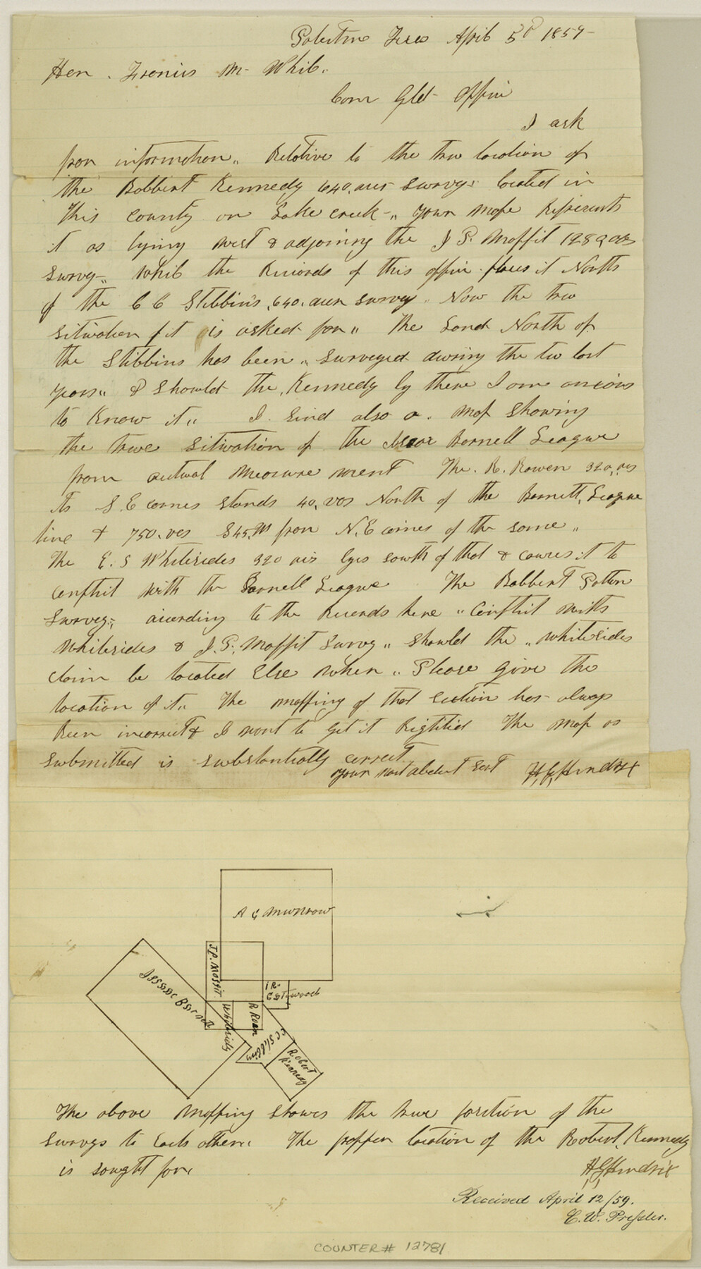
[Sketch and connections of Isaac Barnett league on Lake Creek]
-
Map/Doc
12781
-
Collection
General Map Collection
-
Object Dates
1859/4/5 (Creation Date)
1859/4/12 (File Date)
-
People and Organizations
H.G. Hendrix (Surveyor/Engineer)
-
Counties
Anderson
-
Subjects
Surveying Sketch File
-
Height x Width
14.5 x 8.0 inches
36.8 x 20.3 cm
-
Medium
paper, manuscript
-
Features
Lake Creek
Part of: General Map Collection
Austin County Sketch File 16

Print $74.00
- Digital $50.00
Austin County Sketch File 16
Size 14.3 x 8.8 inches
Map/Doc 13888

Titus County Working Sketch 6

Print $40.00
- Digital $50.00
Titus County Working Sketch 6
1962
Size 29.8 x 55.5 inches
Map/Doc 69367
Map of Tyler County

Print $20.00
- Digital $50.00
Map of Tyler County
1897
Size 42.2 x 39.2 inches
Map/Doc 63081
Gillespie County Boundary File 2

Print $42.00
- Digital $50.00
Gillespie County Boundary File 2
Size 6.7 x 4.0 inches
Map/Doc 53724
Dickens County Sketch File 21

Print $20.00
- Digital $50.00
Dickens County Sketch File 21
1911
Size 16.0 x 12.8 inches
Map/Doc 11324
Sketch of 103rd Meridian, W. L. Showing Conflict of Capitol Leagues

Print $40.00
- Digital $50.00
Sketch of 103rd Meridian, W. L. Showing Conflict of Capitol Leagues
Size 26.9 x 85.1 inches
Map/Doc 65505
Cochran County Sketch File 3

Print $4.00
- Digital $50.00
Cochran County Sketch File 3
Size 8.8 x 11.3 inches
Map/Doc 18540
Brewster County Sketch File N-6

Print $40.00
- Digital $50.00
Brewster County Sketch File N-6
1914
Size 15.8 x 12.7 inches
Map/Doc 10963
Nolan County Boundary File 1

Print $60.00
- Digital $50.00
Nolan County Boundary File 1
Size 8.8 x 3.9 inches
Map/Doc 57617
Flight Mission No. BQR-9K, Frame 48, Brazoria County

Print $20.00
- Digital $50.00
Flight Mission No. BQR-9K, Frame 48, Brazoria County
1952
Size 18.7 x 22.2 inches
Map/Doc 84052
Chambers County Sketch File 50

Print $49.00
- Digital $50.00
Chambers County Sketch File 50
1917
Size 14.4 x 8.8 inches
Map/Doc 18048
You may also like
Chambers County NRC Article 33.136 Sketch 15

Print $62.00
Chambers County NRC Article 33.136 Sketch 15
2025
Map/Doc 97510
Washington County Sketch File 6

Print $20.00
- Digital $50.00
Washington County Sketch File 6
1901
Size 24.7 x 26.0 inches
Map/Doc 12602
Aransas County Sketch File 16

Print $40.00
- Digital $50.00
Aransas County Sketch File 16
1877
Size 16.4 x 12.8 inches
Map/Doc 13147
Sherman County Sketch File 3

Print $26.00
- Digital $50.00
Sherman County Sketch File 3
1925
Size 7.7 x 8.9 inches
Map/Doc 36675
Harris County Working Sketch 42

Print $20.00
- Digital $50.00
Harris County Working Sketch 42
1940
Size 31.8 x 38.5 inches
Map/Doc 65934
A Compleat Map of the West Indies, containing the Coasts of Florida, Louisiana, New Spain, and Terra Firma: with all the Islands

Print $20.00
- Digital $50.00
A Compleat Map of the West Indies, containing the Coasts of Florida, Louisiana, New Spain, and Terra Firma: with all the Islands
1774
Size 13.9 x 19.0 inches
Map/Doc 97400
Ector County Sketch File 3

Print $20.00
- Digital $50.00
Ector County Sketch File 3
1889
Size 16.2 x 35.5 inches
Map/Doc 11417
[Sketch for Mineral Application 26501 - Sabine River, T. A. Oldhausen]
![2833, [Sketch for Mineral Application 26501 - Sabine River, T. A. Oldhausen], General Map Collection](https://historictexasmaps.com/wmedia_w700/maps/2833.tif.jpg)
Print $20.00
- Digital $50.00
[Sketch for Mineral Application 26501 - Sabine River, T. A. Oldhausen]
1931
Size 24.4 x 36.3 inches
Map/Doc 2833
Red River County Working Sketch 83

Print $20.00
- Digital $50.00
Red River County Working Sketch 83
1996
Size 21.0 x 22.3 inches
Map/Doc 72069
Kerr County Boundary File 2

Print $46.00
- Digital $50.00
Kerr County Boundary File 2
Size 15.6 x 26.5 inches
Map/Doc 55984
Montgomery County Rolled Sketch 9

Print $20.00
- Digital $50.00
Montgomery County Rolled Sketch 9
1899
Size 19.5 x 20.1 inches
Map/Doc 6795
Comal County Working Sketch 15

Print $20.00
- Digital $50.00
Comal County Working Sketch 15
1994
Size 44.6 x 31.0 inches
Map/Doc 68181