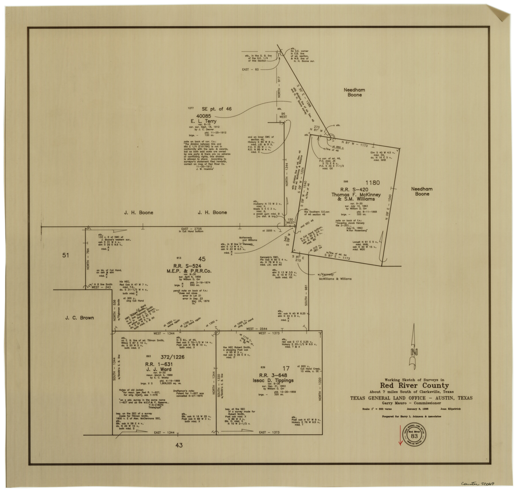
Red River County Working Sketch 83
-
Map/Doc
72069
-
Collection
General Map Collection
-
Object Dates
1/8/1996 (Creation Date)
-
People and Organizations
Joan Kilpatrick (Draftsman)
-
Counties
Red River
-
Subjects
Surveying Working Sketch
-
Height x Width
21.0 x 22.3 inches
53.3 x 56.6 cm
-
Scale
1" = 300 varas
Part of: General Map Collection
Texas, Matagorda Bay, Matagorda Peninsula, Cany Creek to Tiger Island Channel

Print $40.00
- Digital $50.00
Texas, Matagorda Bay, Matagorda Peninsula, Cany Creek to Tiger Island Channel
1933
Size 31.4 x 48.6 inches
Map/Doc 69991
Panola County Rolled Sketch 3

Print $1246.00
- Digital $50.00
Panola County Rolled Sketch 3
1949
Size 10.3 x 15.2 inches
Map/Doc 47978
Old Miscellaneous File 12

Print $14.00
- Digital $50.00
Old Miscellaneous File 12
1899
Size 14.2 x 8.6 inches
Map/Doc 75439
Hudspeth County Rolled Sketch 25

Print $20.00
- Digital $50.00
Hudspeth County Rolled Sketch 25
1909
Size 18.0 x 20.7 inches
Map/Doc 6245
[Sketch for Mineral Application 27669 - Trinity River, Frank R. Graves]
![2860, [Sketch for Mineral Application 27669 - Trinity River, Frank R. Graves], General Map Collection](https://historictexasmaps.com/wmedia_w700/maps/2860-1.tif.jpg)
Print $20.00
- Digital $50.00
[Sketch for Mineral Application 27669 - Trinity River, Frank R. Graves]
1934
Size 27.4 x 42.7 inches
Map/Doc 2860
Glasscock County Sketch File 13

Print $20.00
- Digital $50.00
Glasscock County Sketch File 13
1935
Size 18.8 x 17.8 inches
Map/Doc 11562
Kleberg County Boundary File 1

Print $10.00
- Digital $50.00
Kleberg County Boundary File 1
Size 9.3 x 5.9 inches
Map/Doc 64961
Concho County Working Sketch 20

Print $20.00
- Digital $50.00
Concho County Working Sketch 20
1957
Size 40.0 x 38.1 inches
Map/Doc 68202
Ward County Rolled Sketch 17

Print $20.00
- Digital $50.00
Ward County Rolled Sketch 17
1947
Size 16.2 x 19.5 inches
Map/Doc 8160
Lynn County Sketch File 20

Print $4.00
- Digital $50.00
Lynn County Sketch File 20
1891
Size 8.8 x 10.9 inches
Map/Doc 30527
Flight Mission No. DQN-1K, Frame 35, Calhoun County

Print $20.00
- Digital $50.00
Flight Mission No. DQN-1K, Frame 35, Calhoun County
1953
Size 18.5 x 19.0 inches
Map/Doc 84140
Comanche County Working Sketch 20

Print $20.00
- Digital $50.00
Comanche County Working Sketch 20
1973
Size 20.5 x 15.6 inches
Map/Doc 68154
You may also like

La Salle County Rolled Sketch 11

Print $20.00
- Digital $50.00
La Salle County Rolled Sketch 11
1947
Size 22.1 x 35.8 inches
Map/Doc 6574
Ellis County Boundary File 3

Print $58.00
- Digital $50.00
Ellis County Boundary File 3
Size 14.1 x 122.4 inches
Map/Doc 52950
Brewster County Rolled Sketch 114

Print $20.00
- Digital $50.00
Brewster County Rolled Sketch 114
1964
Size 11.7 x 18.4 inches
Map/Doc 5267
Ladonia, Fannin County, Texas

Print $20.00
Ladonia, Fannin County, Texas
1891
Size 12.0 x 22.1 inches
Map/Doc 89097
Brewster County Rolled Sketch 89

Print $40.00
- Digital $50.00
Brewster County Rolled Sketch 89
1947
Size 37.3 x 63.4 inches
Map/Doc 8499
Harris County Sketch File 11a

Print $6.00
- Digital $50.00
Harris County Sketch File 11a
Size 11.0 x 10.0 inches
Map/Doc 25351
A Map of Matagorda Bay and County With the Adjacent County

Print $20.00
- Digital $50.00
A Map of Matagorda Bay and County With the Adjacent County
1839
Size 33.9 x 43.1 inches
Map/Doc 4855
Baylor County Sketch File 23

Print $60.00
- Digital $50.00
Baylor County Sketch File 23
1927
Size 25.2 x 48.9 inches
Map/Doc 10324
[PSL Blocks A57, 77; B1-B3, T. & P. Block 46, T-1-N]
![90167, [PSL Blocks A57, 77; B1-B3, T. & P. Block 46, T-1-N], Twichell Survey Records](https://historictexasmaps.com/wmedia_w700/maps/90167-1.tif.jpg)
Print $20.00
- Digital $50.00
[PSL Blocks A57, 77; B1-B3, T. & P. Block 46, T-1-N]
Size 33.4 x 36.1 inches
Map/Doc 90167
Orange County Sketch File 28

Print $4.00
- Digital $50.00
Orange County Sketch File 28
1922
Size 11.3 x 8.7 inches
Map/Doc 33356
Map of Bell County

Print $20.00
- Digital $50.00
Map of Bell County
1855
Size 19.2 x 24.4 inches
Map/Doc 829