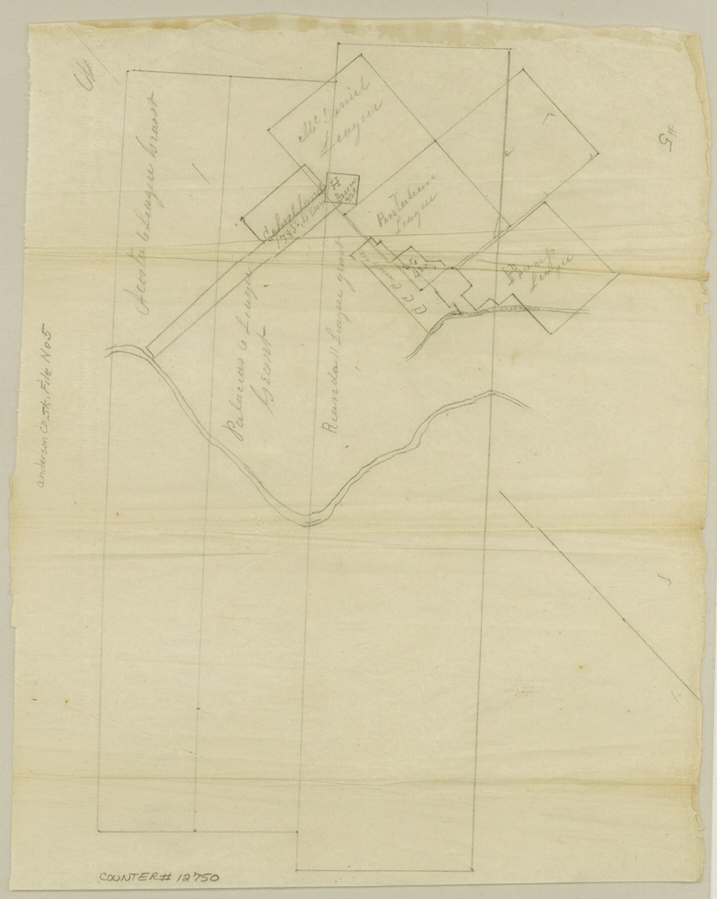
Anderson County Sketch File 5
[Sketch showing conflict between two surveys of School Land and the eleven league grant of Rionda and the six league grants of Palacios and Acosta]
-
Map/Doc
12750
-
Collection
General Map Collection
-
Object Dates
1856/12/18 (Creation Date)
1857/7/6 (File Date)
-
People and Organizations
Geo. W. Tuggle (Surveyor/Engineer)
-
Counties
Anderson
-
Subjects
Surveying Sketch File
-
Height x Width
9.7 x 7.8 inches
24.6 x 19.8 cm
-
Medium
paper, manuscript
-
Features
Lake Creek
Trinity River
Catfish Bayou
Sp[ring] Creek
Part of: General Map Collection
Amistad International Reservoir on Rio Grande 70

Print $20.00
- Digital $50.00
Amistad International Reservoir on Rio Grande 70
1949
Size 28.4 x 39.7 inches
Map/Doc 73356
Map of the County of Nueces and portions of adjoining counties showing the locality, dates and claimants of the several grants made by the government of Spain and Mexico

Print $20.00
- Digital $50.00
Map of the County of Nueces and portions of adjoining counties showing the locality, dates and claimants of the several grants made by the government of Spain and Mexico
1859
Size 37.3 x 39.0 inches
Map/Doc 4677
Index sheet to accompany map of survey for connecting the inland waters along margin of the Gulf of Mexico from Donaldsonville in Louisiana to the Rio Grande River in Texas

Print $20.00
- Digital $50.00
Index sheet to accompany map of survey for connecting the inland waters along margin of the Gulf of Mexico from Donaldsonville in Louisiana to the Rio Grande River in Texas
1873
Size 18.2 x 28.1 inches
Map/Doc 72692
Crosby County Sketch File 11

Print $64.00
- Digital $50.00
Crosby County Sketch File 11
Size 13.8 x 8.9 inches
Map/Doc 20017
Caldwell County Working Sketch 13

Print $20.00
- Digital $50.00
Caldwell County Working Sketch 13
1987
Size 40.3 x 34.3 inches
Map/Doc 67843
Upton County Working Sketch 32

Print $40.00
- Digital $50.00
Upton County Working Sketch 32
1956
Size 55.4 x 37.9 inches
Map/Doc 69528
Marion County Working Sketch 12a

Print $20.00
- Digital $50.00
Marion County Working Sketch 12a
1953
Size 23.9 x 33.2 inches
Map/Doc 70788
Flight Mission No. DCL-7C, Frame 24, Kenedy County

Print $20.00
- Digital $50.00
Flight Mission No. DCL-7C, Frame 24, Kenedy County
1943
Size 15.5 x 15.4 inches
Map/Doc 86016
San Patricio County Rolled Sketch 7B

Print $20.00
- Digital $50.00
San Patricio County Rolled Sketch 7B
1870
Size 42.3 x 29.1 inches
Map/Doc 7573
Carson County Sketch File 4

Print $4.00
- Digital $50.00
Carson County Sketch File 4
1901
Size 9.7 x 6.2 inches
Map/Doc 17351
Guadalupe County Working Sketch 8

Print $20.00
- Digital $50.00
Guadalupe County Working Sketch 8
1955
Size 23.6 x 38.6 inches
Map/Doc 63317
Culberson County Rolled Sketch 35

Print $20.00
- Digital $50.00
Culberson County Rolled Sketch 35
1934
Size 19.1 x 10.9 inches
Map/Doc 5659
You may also like

Map of Georgia, Florida, Alabama, Mississippi and Tennessee engraved to illustrate Mitchell's new intermediate geography

Print $20.00
- Digital $50.00
Map of Georgia, Florida, Alabama, Mississippi and Tennessee engraved to illustrate Mitchell's new intermediate geography
1885
Size 12.2 x 9.0 inches
Map/Doc 93518
Falls County Working Sketch 4

Print $20.00
- Digital $50.00
Falls County Working Sketch 4
1943
Size 24.3 x 22.0 inches
Map/Doc 69179
Aransas County Working Sketch 19

Print $20.00
- Digital $50.00
Aransas County Working Sketch 19
1978
Size 25.1 x 31.1 inches
Map/Doc 67186
Flight Mission No. DAH-9M, Frame 87, Orange County

Print $20.00
- Digital $50.00
Flight Mission No. DAH-9M, Frame 87, Orange County
1953
Size 18.5 x 22.3 inches
Map/Doc 86851
Live Oak County Working Sketch 19

Print $20.00
- Digital $50.00
Live Oak County Working Sketch 19
1962
Size 27.4 x 34.5 inches
Map/Doc 70604
Flight Mission No. DQN-1K, Frame 131, Calhoun County

Print $20.00
- Digital $50.00
Flight Mission No. DQN-1K, Frame 131, Calhoun County
1953
Size 18.6 x 22.4 inches
Map/Doc 84194
Harrison County

Print $20.00
- Digital $50.00
Harrison County
1920
Size 43.0 x 40.0 inches
Map/Doc 77305
Atascosa County Sketch File 2b

Print $6.00
- Digital $50.00
Atascosa County Sketch File 2b
1855
Size 8.8 x 13.2 inches
Map/Doc 13728
[Sketch for Mineral Application 16777]
![65655, [Sketch for Mineral Application 16777], General Map Collection](https://historictexasmaps.com/wmedia_w700/maps/65655-1.tif.jpg)
Print $40.00
- Digital $50.00
[Sketch for Mineral Application 16777]
Size 19.8 x 80.3 inches
Map/Doc 65655
Map of McCulloch County

Print $20.00
- Digital $50.00
Map of McCulloch County
1858
Size 26.6 x 22.4 inches
Map/Doc 3855
Upton County Rolled Sketch 23

Print $20.00
- Digital $50.00
Upton County Rolled Sketch 23
1940
Size 25.7 x 39.4 inches
Map/Doc 8074