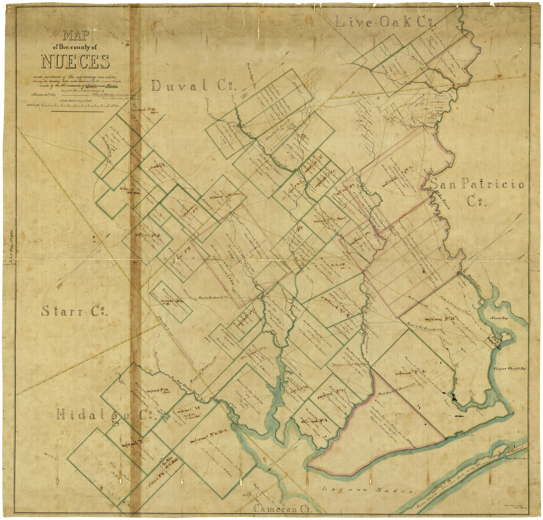
Map of the County of Nueces and portions of adjoining counties showing the locality, dates and claimants of the several grants made by the government of Spain and Mexico
-
Map/Doc
4677
-
Collection
General Map Collection
-
Object Dates
11/20/1859 (Creation Date)
2/1/1860 (File Date)
-
People and Organizations
Nueces District (Publisher)
Felix A. Blucher (Surveyor/Engineer)
Felix A. Blucher (Compiler)
Felix A. Blucher (Draftsman)
-
Counties
Nueces San Patricio Kleberg Kenedy Jim Wells
-
Subjects
County
-
Height x Width
37.3 x 39.0 inches
94.7 x 99.1 cm
-
Comments
Conservation funded in 2001 with donation from Frost Bank.
-
Features
Worthington [Rancho]
S[an]ta Rosa
Rancho del Tule
Los Olmos Creek
El Grullo [Lake]
Rancho India Puerta
Brownsville
Oso Creek
Corpus Christi Bay
Corpus Christi
Oso
Britten [Rancho]
Mustang Island
Santa Petronila Creek
Escondido Creek
Jaboncillas Creek
Road to Rio Grande City
Rancho Escondida
Rancho de Sa[nta] Getrudis
Tranquitas Creek
C. Balero [Rancho]
Blucher's Rancho
Clark's Rancho
Padre Island
Los Pajaros
Mail Route to Brownsville
Rancho W. W. Chapman
E. Mann [Rancho]
Casablanca
Road to Eagle Pass
Cloa
Dix
Valeña
Laguna Madre
Road to Laredo
Tulosa
Salto Mountain
Paisano Creek
Road to Brownsville
Banquete
Lagarto Creek
Road to Banquetes [sic] and San Diego
San Diego Road
Encinal
Corpus Christi Pass
Casablanca [Rancho]
Baskins R[ancho]
Walworth's Rancho
Agua Dulce Creek
Rancho de los Presenos
Sloss [Rancho]
J. Vales Rancho
Anacuas Creek
San Diego Creek
Agua Paquita Creek
J. Vates Rancho
Dwyer [Rancho]
E. Mann [Rancho]
Beldon
A. Perez Rancho
Macklenburgers Rancho
Casa Ramirenño
Vilena Mountain
Fort Merrill
Ramireño Creek
Chiltipin Creek
Road to Eagle Pass
Puentecilas Creek
Banquetes Road
Nueces Bay
Nueces River
Nuecestown
W. Rogers [Rancho]
McEvers [Ranch]
Morris Rancho
Carrita Creek
San Fernando Creek
Merily's Rancho
Carancahuas Creek
Barranco Blanco [Rancho]
Durst's Rancho
Dennis O'Farrell Ranch
Rancho Trinidad
Pintas Creek
J. Basse's Rancho
O'Reilly [Rancho]
S[anta] Margarita
San Patricio
J. Mann [Rancho]
Part of: General Map Collection
Jackson County Sketch File 27

Print $20.00
- Digital $50.00
Jackson County Sketch File 27
1938
Size 25.6 x 24.8 inches
Map/Doc 11847
[Map of Texas showing Counties, County Seats, Rivers and Location of State Boundary Line Markers]
![60304, [Map of Texas showing Counties, County Seats, Rivers and Location of State Boundary Line Markers], General Map Collection](https://historictexasmaps.com/wmedia_w700/maps/60304.tif.jpg)
Print $20.00
- Digital $50.00
[Map of Texas showing Counties, County Seats, Rivers and Location of State Boundary Line Markers]
1950
Size 30.2 x 32.9 inches
Map/Doc 60304
Map of Comal County

Print $20.00
- Digital $50.00
Map of Comal County
1871
Size 16.0 x 19.7 inches
Map/Doc 3430
Hudspeth County Rolled Sketch 59

Print $40.00
- Digital $50.00
Hudspeth County Rolled Sketch 59
Size 69.2 x 42.8 inches
Map/Doc 9224
Eastland County Working Sketch 10

Print $20.00
- Digital $50.00
Eastland County Working Sketch 10
1919
Size 20.2 x 16.3 inches
Map/Doc 68791
Flight Mission No. CLL-1N, Frame 187, Willacy County

Print $20.00
- Digital $50.00
Flight Mission No. CLL-1N, Frame 187, Willacy County
1954
Size 18.4 x 22.1 inches
Map/Doc 87057
Presidio County Sketch File 116

Print $86.00
- Digital $50.00
Presidio County Sketch File 116
1993
Size 11.4 x 8.7 inches
Map/Doc 34842
Morris County Rolled Sketch 2A

Print $20.00
- Digital $50.00
Morris County Rolled Sketch 2A
Size 24.3 x 19.1 inches
Map/Doc 10239
La Salle County Rolled Sketch 15

Print $20.00
- Digital $50.00
La Salle County Rolled Sketch 15
Size 22.0 x 32.4 inches
Map/Doc 6579
Flight Mission No. BRE-2P, Frame 42, Nueces County

Print $20.00
- Digital $50.00
Flight Mission No. BRE-2P, Frame 42, Nueces County
1956
Size 18.5 x 22.4 inches
Map/Doc 86744
Dimmit County Working Sketch 27

Print $20.00
- Digital $50.00
Dimmit County Working Sketch 27
1956
Size 20.3 x 23.0 inches
Map/Doc 68688
Orange County Working Sketch 38

Print $20.00
- Digital $50.00
Orange County Working Sketch 38
1964
Size 25.4 x 27.7 inches
Map/Doc 71370
You may also like
Jim Hogg County Sketch File 6a

Print $6.00
- Digital $50.00
Jim Hogg County Sketch File 6a
1939
Size 11.1 x 8.7 inches
Map/Doc 28408
Fannin County Boundary File 3

Print $36.00
- Digital $50.00
Fannin County Boundary File 3
Size 13.2 x 8.8 inches
Map/Doc 53295
Mills County Working Sketch 17

Print $20.00
- Digital $50.00
Mills County Working Sketch 17
1963
Size 20.4 x 17.9 inches
Map/Doc 71047
Flight Mission No. DCL-7C, Frame 56, Kenedy County

Print $20.00
- Digital $50.00
Flight Mission No. DCL-7C, Frame 56, Kenedy County
1943
Size 15.4 x 15.2 inches
Map/Doc 86044
Map of the State of Texas

Print $20.00
- Digital $50.00
Map of the State of Texas
1881
Size 15.7 x 21.7 inches
Map/Doc 96614
Oaklawn Subdivision

Print $20.00
- Digital $50.00
Oaklawn Subdivision
Size 17.6 x 22.4 inches
Map/Doc 92410
Wichita County Rolled Sketch 20

Print $45.00
- Digital $50.00
Wichita County Rolled Sketch 20
Size 11.0 x 14.5 inches
Map/Doc 49546
South Part of Brewster Co.

Print $20.00
- Digital $50.00
South Part of Brewster Co.
1955
Size 47.3 x 39.6 inches
Map/Doc 77221
Kent County Working Sketch Graphic Index

Print $20.00
- Digital $50.00
Kent County Working Sketch Graphic Index
1971
Size 44.7 x 37.0 inches
Map/Doc 76604
Matagorda County NRC Article 33.136 Sketch 18

Print $24.00
Matagorda County NRC Article 33.136 Sketch 18
2023
Map/Doc 97283
Galveston to Rio Grande

Print $20.00
- Digital $50.00
Galveston to Rio Grande
1961
Size 44.4 x 37.2 inches
Map/Doc 69954
Gaines County Working Sketch 17

Print $20.00
- Digital $50.00
Gaines County Working Sketch 17
1964
Size 47.6 x 34.5 inches
Map/Doc 69317