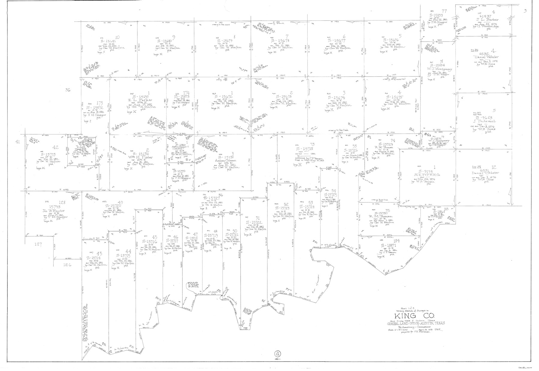
King County Working Sketch 15
-
Map/Doc
70179
-
Collection
General Map Collection
-
Object Dates
4/23/1979 (Creation Date)
-
People and Organizations
Joan Kilpatrick (Draftsman)
-
Counties
King
-
Subjects
Surveying Working Sketch
-
Height x Width
41.6 x 60.4 inches
105.7 x 153.4 cm
-
Scale
1" = 300 varas
Part of: General Map Collection
Flight Mission No. DAH-10M, Frame 45, Orange County

Print $20.00
- Digital $50.00
Flight Mission No. DAH-10M, Frame 45, Orange County
1953
Size 18.8 x 22.5 inches
Map/Doc 86880
Frio County Sketch File 13

Print $10.00
- Digital $50.00
Frio County Sketch File 13
1948
Size 11.3 x 8.8 inches
Map/Doc 23136
Rockwall County Working Sketch 2

Print $20.00
- Digital $50.00
Rockwall County Working Sketch 2
1923
Size 20.9 x 16.8 inches
Map/Doc 63594
Anderson County Working Sketch 32

Print $20.00
- Digital $50.00
Anderson County Working Sketch 32
1966
Size 23.7 x 21.9 inches
Map/Doc 67032
Knox County Sketch File 10a

Print $40.00
- Digital $50.00
Knox County Sketch File 10a
1902
Size 9.5 x 19.0 inches
Map/Doc 29223
Map of Zavalla County

Print $20.00
- Digital $50.00
Map of Zavalla County
1862
Size 24.2 x 20.5 inches
Map/Doc 4180
Hale County Boundary File 9

Print $68.00
- Digital $50.00
Hale County Boundary File 9
Size 14.2 x 8.8 inches
Map/Doc 54111
Bandera County Working Sketch 54

Print $20.00
- Digital $50.00
Bandera County Working Sketch 54
1988
Size 30.4 x 30.1 inches
Map/Doc 67650
Somervell County Working Sketch 4

Print $20.00
- Digital $50.00
Somervell County Working Sketch 4
1975
Size 38.3 x 29.7 inches
Map/Doc 63908
Parker County Working Sketch 15

Print $20.00
- Digital $50.00
Parker County Working Sketch 15
1982
Map/Doc 71465
Hudspeth County Sketch File 44

Print $6.00
- Digital $50.00
Hudspeth County Sketch File 44
1886
Size 11.0 x 8.5 inches
Map/Doc 27027
Flight Mission No. CRK-3P, Frame 129, Refugio County

Print $20.00
- Digital $50.00
Flight Mission No. CRK-3P, Frame 129, Refugio County
1956
Size 18.5 x 22.4 inches
Map/Doc 86917
You may also like
Webb County Working Sketch 14

Print $20.00
- Digital $50.00
Webb County Working Sketch 14
1923
Size 19.3 x 32.2 inches
Map/Doc 72379
Somervell County Sketch File 3

Print $6.00
- Digital $50.00
Somervell County Sketch File 3
1858
Size 8.2 x 3.9 inches
Map/Doc 36797
Wise County Working Sketch 3

Print $20.00
- Digital $50.00
Wise County Working Sketch 3
1946
Size 28.4 x 36.9 inches
Map/Doc 72617
Gulf Intracoastal Waterway - Aransas Bay to Corpus Christi Bay, Modified Route of Main Channel Location of Spoil Disposal Areas

Print $20.00
- Digital $50.00
Gulf Intracoastal Waterway - Aransas Bay to Corpus Christi Bay, Modified Route of Main Channel Location of Spoil Disposal Areas
1961
Size 31.4 x 42.1 inches
Map/Doc 61829
Winkler County Sketch File 10

Print $4.00
- Digital $50.00
Winkler County Sketch File 10
1910
Size 9.1 x 8.3 inches
Map/Doc 40486
Right of Way and Track Map International & Gt Northern Ry. operated by the International & Gt. Northern Ry. Co., San Antonio Division

Print $40.00
- Digital $50.00
Right of Way and Track Map International & Gt Northern Ry. operated by the International & Gt. Northern Ry. Co., San Antonio Division
1917
Size 25.4 x 58.1 inches
Map/Doc 64787
[Blocks 341, G-5, G-12, TCRRCo.]
![60298, [Blocks 341, G-5, G-12, TCRRCo.], General Map Collection](https://historictexasmaps.com/wmedia_w700/maps/60298-1.tif.jpg)
Print $20.00
- Digital $50.00
[Blocks 341, G-5, G-12, TCRRCo.]
1954
Size 15.1 x 26.1 inches
Map/Doc 60298
Map of Anderson County, Texas

Print $20.00
- Digital $50.00
Map of Anderson County, Texas
1879
Size 18.5 x 21.7 inches
Map/Doc 377
Kinney County

Print $40.00
- Digital $50.00
Kinney County
1909
Size 48.4 x 42.7 inches
Map/Doc 16868
Kimble County Rolled Sketch 26

Print $20.00
- Digital $50.00
Kimble County Rolled Sketch 26
1960
Size 26.4 x 21.6 inches
Map/Doc 6516
Correct Map Lamb County (skeleton sketch)

Print $40.00
- Digital $50.00
Correct Map Lamb County (skeleton sketch)
Size 56.2 x 79.4 inches
Map/Doc 93139
Map and Profile No. 1 from the Red River to the Rio Grande; from explorations and surveys made under the direction of the Hon. Jefferson Davis, Secretary of War by Captain John Pope, Corps. Topl Engrs.

Print $40.00
- Digital $50.00
Map and Profile No. 1 from the Red River to the Rio Grande; from explorations and surveys made under the direction of the Hon. Jefferson Davis, Secretary of War by Captain John Pope, Corps. Topl Engrs.
Size 30.2 x 59.9 inches
Map/Doc 95176