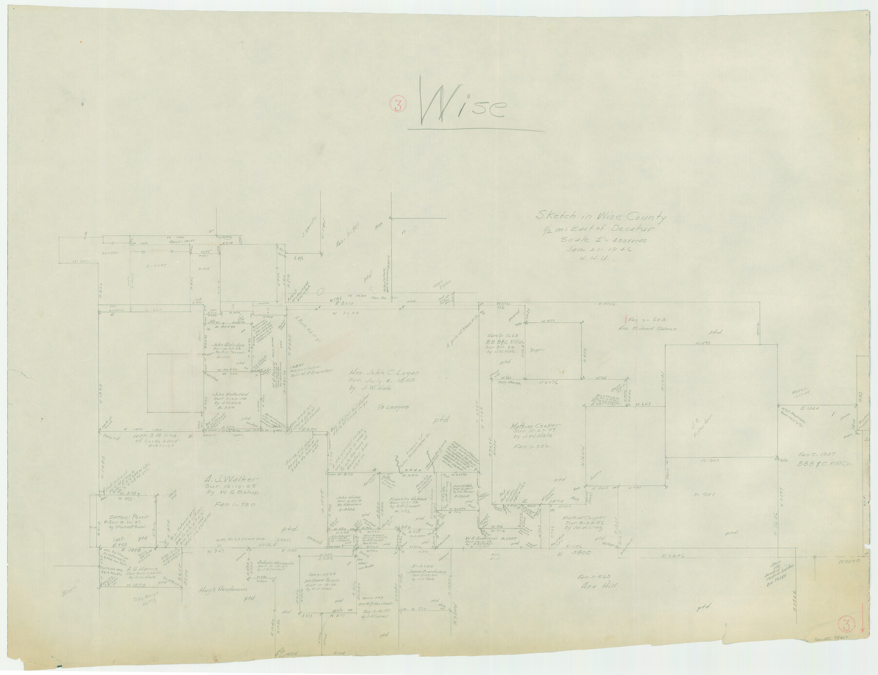
Wise County Working Sketch 3
-
Map/Doc
72617
-
Collection
General Map Collection
-
Object Dates
1/21/1946 (Creation Date)
-
People and Organizations
Herbert H. Ulbricht (Draftsman)
-
Counties
Wise
-
Subjects
Surveying Working Sketch
-
Height x Width
28.4 x 36.9 inches
72.1 x 93.7 cm
-
Scale
1" = 400 varas
Part of: General Map Collection
Val Verde County Rolled Sketch 72A

Print $20.00
- Digital $50.00
Val Verde County Rolled Sketch 72A
Size 15.5 x 37.8 inches
Map/Doc 8135
Carson County Rolled Sketch 1

Print $20.00
- Digital $50.00
Carson County Rolled Sketch 1
Size 31.2 x 33.4 inches
Map/Doc 8580
Ellis County Working Sketch 2

Print $20.00
- Digital $50.00
Ellis County Working Sketch 2
1947
Size 27.0 x 25.6 inches
Map/Doc 69018
Bexar County Sketch File 46

Print $40.00
- Digital $50.00
Bexar County Sketch File 46
1888
Size 24.7 x 22.6 inches
Map/Doc 10924
Flight Mission No. CUG-3P, Frame 22, Kleberg County

Print $20.00
- Digital $50.00
Flight Mission No. CUG-3P, Frame 22, Kleberg County
1956
Size 18.5 x 22.1 inches
Map/Doc 86232

Archer County

Print $20.00
- Digital $50.00
Archer County
1926
Size 43.8 x 38.7 inches
Map/Doc 77202
Oldham County Sketch File 13

Print $40.00
- Digital $50.00
Oldham County Sketch File 13
1902
Size 14.3 x 12.3 inches
Map/Doc 33260
Railroad Track Map, H&TCRRCo., Falls County, Texas

Print $4.00
- Digital $50.00
Railroad Track Map, H&TCRRCo., Falls County, Texas
1918
Size 11.7 x 18.3 inches
Map/Doc 62853

Houston County

Print $20.00
- Digital $50.00
Houston County
1877
Size 25.9 x 26.2 inches
Map/Doc 3684
Webb County Sketch File B2

Print $4.00
- Digital $50.00
Webb County Sketch File B2
1909
Size 13.9 x 8.1 inches
Map/Doc 39656
You may also like
Guadalupe County Sketch File 19

Print $4.00
- Digital $50.00
Guadalupe County Sketch File 19
Size 14.3 x 8.7 inches
Map/Doc 24697
Liberty County Working Sketch 14

Print $20.00
- Digital $50.00
Liberty County Working Sketch 14
1919
Size 17.0 x 25.4 inches
Map/Doc 70473
Clay County Sketch File 12

Print $4.00
- Digital $50.00
Clay County Sketch File 12
1873
Size 13.0 x 8.2 inches
Map/Doc 18411
Right of Way and Track Map for The Missouri, Kansas & Texas Railway of Texas

Print $40.00
- Digital $50.00
Right of Way and Track Map for The Missouri, Kansas & Texas Railway of Texas
1918
Size 25.9 x 56.0 inches
Map/Doc 64527
Jeff Davis County Working Sketch 32

Print $40.00
- Digital $50.00
Jeff Davis County Working Sketch 32
1975
Size 66.7 x 43.7 inches
Map/Doc 66527
Map of Val Verde County

Print $40.00
- Digital $50.00
Map of Val Verde County
1898
Size 80.4 x 70.4 inches
Map/Doc 82014
[Map] of Goliad Land District
![3586, [Map] of Goliad Land District, General Map Collection](https://historictexasmaps.com/wmedia_w700/maps/3586-1.tif.jpg)
Print $20.00
- Digital $50.00
[Map] of Goliad Land District
1856
Size 33.5 x 25.2 inches
Map/Doc 3586
Smith County Working Sketch 12

Print $20.00
- Digital $50.00
Smith County Working Sketch 12
1961
Size 30.3 x 30.6 inches
Map/Doc 63897
Brewster County Working Sketch 52

Print $20.00
- Digital $50.00
Brewster County Working Sketch 52
1951
Size 28.7 x 37.3 inches
Map/Doc 67586
[Blocks D, Q, and Z]
![92522, [Blocks D, Q, and Z], Twichell Survey Records](https://historictexasmaps.com/wmedia_w700/maps/92522-1.tif.jpg)
Print $20.00
- Digital $50.00
[Blocks D, Q, and Z]
Size 17.9 x 22.6 inches
Map/Doc 92522

Upton County Sketch File 15

Print $20.00
- Digital $50.00
Upton County Sketch File 15
1927
Size 34.3 x 19.5 inches
Map/Doc 12513