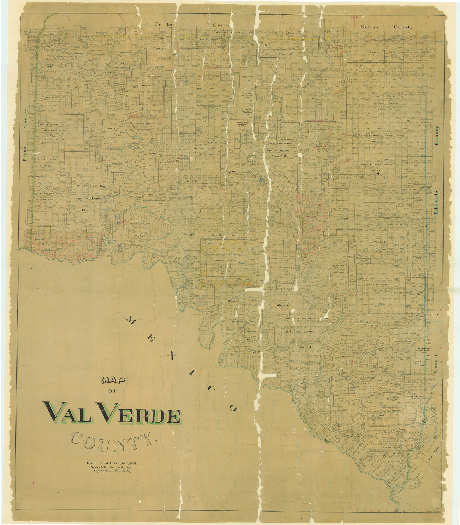
Map of Val Verde County
-
Map/Doc
82014
-
Collection
General Map Collection
-
Object Dates
1898 (Creation Date)
-
People and Organizations
Texas General Land Office (Publisher)
E. von Rosenberg (Draftsman)
E. von Rosenberg (Compiler)
-
Counties
Val Verde
-
Subjects
County
-
Height x Width
80.4 x 70.4 inches
204.2 x 178.8 cm
-
Comments
See counter 82013 for west part. See counter 82014 for digitally combined image.
Conservation funded in 2004 with donation from Glen Sample Ely. -
Features
Howards Creek
Johnsons Run
McKees
Johnsons Ranch
North Prong of Buckley's Creek
Fielder's Creek
Col. Shaftern's Trail
Indian Trail
Buckley's Creek
Bandera Road
China Creek
Dry Creek
Lowe's Creek
Devil's River
Beaver Lake
Old Camp Shafter
Old Mouth of Howard's Creek
Oppenheimer Springs
Chalk Bluff
Yellow Bluff
Ricardo Creek
Dry Devil's River
Dolan Springs
Pecan Springs
Blue Hills
Comstock and Ozona Road
Ozona Road
Comstock Road
Norris Ranch
Lewis Cañon
Fielders Ranch
Camp Hudson
East Fork of Dolan's Creek
Dolan's Creek
Jack Springs
Jack Branch of Ricardo Creek
Grape Springs
Sycamore Springs
R&M Ranch
Osman
Ames Ranch
Cañon Grande
Willow Springs
Langtry
GH&SA
Dead Man's Cañon
Rio Grande
Red Bluff Cañon
Southern Pacific Railroad Company
GH&SA Bridge
Deadmans Creek
Cow Creek
Seminole Springs
Painted Cave Springs
Painted Cave Station
Abandoned Railroad
Elanders Old Station
Comstock
Section House
Almonds Ranch
Evans Creek
Satan's Creek
West Prong of Cow Creek
Rocky Creek
West Fork of Sycamore Creek
East Prong of Cow Creek
Feely Station
California Creek
Lone Hill
Bullis Creek
Bluff Creek
Griner Springs
California Creek
Painted Cave Creek
West Prong of Painted Cave Creek
Goodenough Springs
Lange Cañon
San Pedro Creek
North Fork of San Pedro Creek
East Fork of San Pedro Creek
Middle Fork of Sycamore Creek
West Fork of Sycamore Creek
Dry Branch of San Pedro Creek
Devil's River Station
Sycamore Creek
Head Springs
Stampede Creek
Sienagas Creek
McKee's
Sienegas Springs
Arroyo los Poloncillos
Zacatosa Creek
Del Rio
San Felipe Creek
Poloncillo Mountain
Sugar Loaf Mountain
Conical Mountain
San Felipe
Maverick's Creek
Mud Creek
Geddis Spring
Pecos River
Part of: General Map Collection
Dallam County Sketch File 9

Print $40.00
- Digital $50.00
Dallam County Sketch File 9
1914
Size 9.0 x 7.7 inches
Map/Doc 20357
Archer County Working Sketch 6

Print $20.00
- Digital $50.00
Archer County Working Sketch 6
1920
Size 16.9 x 27.7 inches
Map/Doc 67146
Eastland County Boundary File 13

Print $68.00
- Digital $50.00
Eastland County Boundary File 13
Size 8.0 x 3.7 inches
Map/Doc 52785
Castro County Sketch File 4g

Print $4.00
- Digital $50.00
Castro County Sketch File 4g
Size 12.0 x 8.9 inches
Map/Doc 17477
Webb County Working Sketch 5

Print $20.00
- Digital $50.00
Webb County Working Sketch 5
1909
Size 20.1 x 15.4 inches
Map/Doc 72370
[Beaumont, Sour Lake and Western Ry. Right of Way and Alignment - Frisco]
![64119, [Beaumont, Sour Lake and Western Ry. Right of Way and Alignment - Frisco], General Map Collection](https://historictexasmaps.com/wmedia_w700/maps/64119.tif.jpg)
Print $20.00
- Digital $50.00
[Beaumont, Sour Lake and Western Ry. Right of Way and Alignment - Frisco]
1910
Size 20.0 x 45.8 inches
Map/Doc 64119
Harbor Pass and Bar at Brazos Santiago, Texas

Print $20.00
- Digital $50.00
Harbor Pass and Bar at Brazos Santiago, Texas
1871
Size 18.2 x 27.0 inches
Map/Doc 73037
Map of the District of San Patricio and Nueces

Print $40.00
- Digital $50.00
Map of the District of San Patricio and Nueces
Size 93.9 x 36.4 inches
Map/Doc 93367
Flight Mission No. DCL-6C, Frame 121, Kenedy County

Print $20.00
- Digital $50.00
Flight Mission No. DCL-6C, Frame 121, Kenedy County
1943
Size 18.6 x 22.4 inches
Map/Doc 85951
Roberts County Working Sketch 8

Print $20.00
- Digital $50.00
Roberts County Working Sketch 8
1963
Size 21.9 x 26.0 inches
Map/Doc 63534
Flight Mission No. CRE-1R, Frame 134, Jackson County

Print $20.00
- Digital $50.00
Flight Mission No. CRE-1R, Frame 134, Jackson County
1956
Size 16.2 x 16.0 inches
Map/Doc 85342
Harris County Sketch File 104

Print $2.00
- Digital $50.00
Harris County Sketch File 104
1992
Size 11.2 x 8.9 inches
Map/Doc 25974
You may also like
Falls County Working Sketch 1

Print $20.00
- Digital $50.00
Falls County Working Sketch 1
1922
Size 23.0 x 33.1 inches
Map/Doc 69176
Webb County Sketch File 12-1

Print $16.00
- Digital $50.00
Webb County Sketch File 12-1
1886
Size 13.0 x 8.3 inches
Map/Doc 39793
Hudspeth County Sketch File 33

Print $6.00
- Digital $50.00
Hudspeth County Sketch File 33
1952
Size 11.3 x 8.8 inches
Map/Doc 26994
Nueces County Sketch File 15

Print $4.00
- Digital $50.00
Nueces County Sketch File 15
1874
Size 7.9 x 9.9 inches
Map/Doc 32545
Val Verde County Sketch File Z11

Print $40.00
- Digital $50.00
Val Verde County Sketch File Z11
1895
Size 17.6 x 12.7 inches
Map/Doc 39138
Harris County Rolled Sketch 41(1)

Print $13.00
- Digital $50.00
Harris County Rolled Sketch 41(1)
Size 10.0 x 15.3 inches
Map/Doc 45789
Brooks County Working Sketch 11

Print $20.00
- Digital $50.00
Brooks County Working Sketch 11
1942
Size 41.8 x 23.5 inches
Map/Doc 67795
Wm. H. Bush Estate resurveyed by W. D. Twichell May 1905

Print $40.00
- Digital $50.00
Wm. H. Bush Estate resurveyed by W. D. Twichell May 1905
1905
Size 36.2 x 57.1 inches
Map/Doc 89784
Flight Mission No. CRC-3R, Frame 106, Chambers County

Print $20.00
- Digital $50.00
Flight Mission No. CRC-3R, Frame 106, Chambers County
1956
Size 18.8 x 22.6 inches
Map/Doc 84844
Bastrop County Working Sketch 4

Print $20.00
- Digital $50.00
Bastrop County Working Sketch 4
1921
Size 16.1 x 18.3 inches
Map/Doc 67304
[I. & G. N, Sections 8-13]
![91047, [I. & G. N, Sections 8-13], Twichell Survey Records](https://historictexasmaps.com/wmedia_w700/maps/91047-1.tif.jpg)
Print $20.00
- Digital $50.00
[I. & G. N, Sections 8-13]
Size 25.2 x 12.1 inches
Map/Doc 91047
Brewster County Sketch File 57

Print $6.00
- Digital $50.00
Brewster County Sketch File 57
2008
Size 11.0 x 8.5 inches
Map/Doc 88871