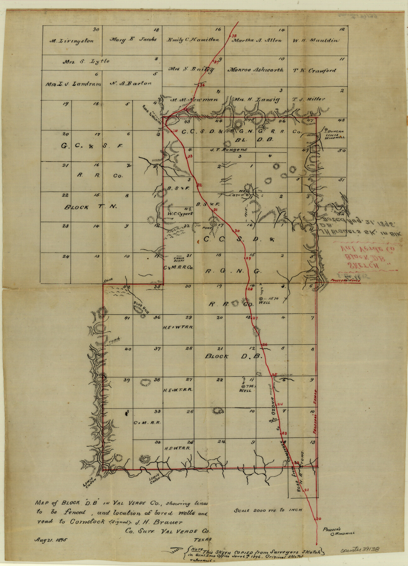
Val Verde County Sketch File Z11
[Sketch of Block DB northwest from Del Rio]
-
Map/Doc
39138
-
Collection
General Map Collection
-
Object Dates
8/21/1895 (Creation Date)
-
People and Organizations
J.H. Brauer (Surveyor/Engineer)
-
Counties
Val Verde
-
Subjects
Surveying Sketch File
-
Height x Width
17.6 x 12.7 inches
44.7 x 32.3 cm
-
Medium
paper, manuscript
-
Scale
1" = 2000 varas
-
Features
Road to Wilkins
Blue Hills
Chalk Bluff
Road from Comstock to Ozona
Part of: General Map Collection
Flight Mission No. DAG-23K, Frame 148, Matagorda County

Print $20.00
- Digital $50.00
Flight Mission No. DAG-23K, Frame 148, Matagorda County
1953
Size 18.6 x 22.4 inches
Map/Doc 86496
Jasper County Working Sketch 30

Print $20.00
- Digital $50.00
Jasper County Working Sketch 30
1956
Size 33.5 x 38.6 inches
Map/Doc 66492
Brewster County Rolled Sketch 114

Print $20.00
- Digital $50.00
Brewster County Rolled Sketch 114
1964
Size 11.4 x 18.2 inches
Map/Doc 5282
Pecos County Working Sketch 85

Print $20.00
- Digital $50.00
Pecos County Working Sketch 85
1962
Size 45.4 x 35.7 inches
Map/Doc 71557
Newton County Working Sketch 26

Print $20.00
- Digital $50.00
Newton County Working Sketch 26
1953
Size 18.3 x 16.4 inches
Map/Doc 71272
Bowie County Rolled Sketch 5

Print $20.00
- Digital $50.00
Bowie County Rolled Sketch 5
Size 33.1 x 44.5 inches
Map/Doc 8457
Webb County Sketch File 2 and 2A

Print $20.00
- Digital $50.00
Webb County Sketch File 2 and 2A
Size 39.8 x 29.6 inches
Map/Doc 10428
Nueces County Sketch File 69

Print $6.00
- Digital $50.00
Nueces County Sketch File 69
Size 11.1 x 8.7 inches
Map/Doc 33004
Parker County

Print $20.00
- Digital $50.00
Parker County
1942
Size 46.7 x 37.9 inches
Map/Doc 73258
Travis County Working Sketch 61

Print $20.00
- Digital $50.00
Travis County Working Sketch 61
1995
Size 20.9 x 24.7 inches
Map/Doc 69445
Galveston County Sketch File 69

Print $226.00
- Digital $50.00
Galveston County Sketch File 69
1884
Size 14.4 x 9.0 inches
Map/Doc 23815
Gillespie County Rolled Sketch 10

Print $3.00
- Digital $50.00
Gillespie County Rolled Sketch 10
2017
Size 16.1 x 10.7 inches
Map/Doc 94413
You may also like

MKT (Missouri Kansas Texas) Katy Railroad Time Tables

Print $54.00
- Digital $50.00
MKT (Missouri Kansas Texas) Katy Railroad Time Tables
1946
Size 9.3 x 16.4 inches
Map/Doc 93981
Deaf Smith County Sketch File 7

Print $4.00
- Digital $50.00
Deaf Smith County Sketch File 7
1917
Size 11.3 x 9.0 inches
Map/Doc 20664
Flight Mission No. DCL-6C, Frame 119, Kenedy County

Print $20.00
- Digital $50.00
Flight Mission No. DCL-6C, Frame 119, Kenedy County
1943
Size 18.6 x 22.3 inches
Map/Doc 85949
Flight Mission No. DAG-18K, Frame 179, Matagorda County

Print $20.00
- Digital $50.00
Flight Mission No. DAG-18K, Frame 179, Matagorda County
1952
Size 16.2 x 16.0 inches
Map/Doc 86371
Flight Mission No. DQN-3K, Frame 73, Calhoun County

Print $20.00
- Digital $50.00
Flight Mission No. DQN-3K, Frame 73, Calhoun County
1953
Size 18.6 x 22.4 inches
Map/Doc 84364
Controlled Mosaic by Jack Amman Photogrammetric Engineers, Inc - Sheet 45

Print $20.00
- Digital $50.00
Controlled Mosaic by Jack Amman Photogrammetric Engineers, Inc - Sheet 45
1954
Size 20.0 x 24.0 inches
Map/Doc 83504
Lubbock County

Print $20.00
- Digital $50.00
Lubbock County
1879
Size 21.3 x 19.1 inches
Map/Doc 4583
Travis County Sketch File 72

Print $4.00
- Digital $50.00
Travis County Sketch File 72
1850
Size 12.7 x 8.4 inches
Map/Doc 38460
Planiglobii Terrestris Mappa Universalis Utrumqs Hemisphaerium Orient et Occidentale

Print $20.00
- Digital $50.00
Planiglobii Terrestris Mappa Universalis Utrumqs Hemisphaerium Orient et Occidentale
1746
Size 21.4 x 24.4 inches
Map/Doc 96580
Mills County Working Sketch Graphic Index

Print $20.00
- Digital $50.00
Mills County Working Sketch Graphic Index
1976
Size 35.6 x 45.1 inches
Map/Doc 76643
Webb County Sketch File 66

Print $20.00
- Digital $50.00
Webb County Sketch File 66
1950
Size 13.4 x 20.6 inches
Map/Doc 12655