Travis County Sketch File 72
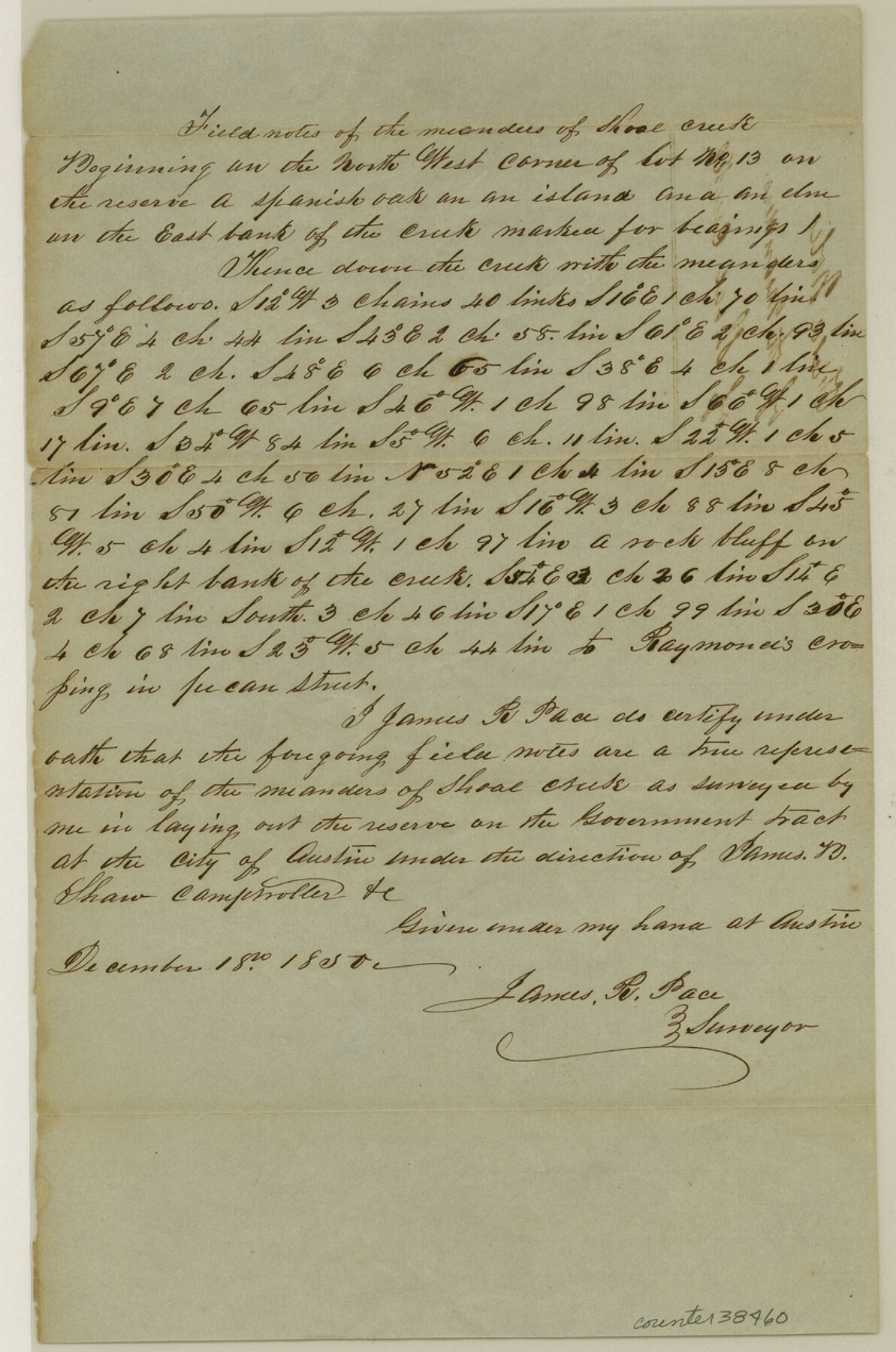
[Field notes of the meanders of Shoal Creek]
-
Map/Doc
38460
-
Collection
General Map Collection
-
Object Dates
12/18/1850 (Creation Date)
12/4/1984 (File Date)
-
People and Organizations
James R. Pace (Surveyor/Engineer)
-
Counties
Travis
-
Subjects
Surveying Sketch File
-
Height x Width
12.7 x 8.4 inches
32.3 x 21.3 cm
-
Medium
paper, manuscript
-
Features
Shoal Creek
Raymond's Crossing [on Shoal Creek]
Austin
Part of: General Map Collection
McLennan County Sketch File 1b

Print $4.00
- Digital $50.00
McLennan County Sketch File 1b
Size 8.3 x 8.1 inches
Map/Doc 31228
Delta County Working Sketch 4

Print $20.00
- Digital $50.00
Delta County Working Sketch 4
Size 16.8 x 21.1 inches
Map/Doc 62179
Hunt County Sketch File 8

Print $4.00
- Digital $50.00
Hunt County Sketch File 8
1848
Size 8.2 x 12.7 inches
Map/Doc 27097
Flight Mission No. CRC-4R, Frame 79, Chambers County

Print $20.00
- Digital $50.00
Flight Mission No. CRC-4R, Frame 79, Chambers County
1956
Size 18.9 x 22.6 inches
Map/Doc 84883
Potter County Sketch File 11

Print $4.00
- Digital $50.00
Potter County Sketch File 11
1890
Size 14.0 x 8.8 inches
Map/Doc 34397
Mexico and Guatemala

Print $20.00
- Digital $50.00
Mexico and Guatemala
1850
Size 14.6 x 17.9 inches
Map/Doc 93652
Parmer County Working Sketch 2

Print $20.00
- Digital $50.00
Parmer County Working Sketch 2
1914
Map/Doc 71470
Orange County Rolled Sketch 31

Print $40.00
- Digital $50.00
Orange County Rolled Sketch 31
1926
Size 88.7 x 35.2 inches
Map/Doc 9651
Mitchell County Sketch File 12

Print $20.00
- Digital $50.00
Mitchell County Sketch File 12
1912
Size 25.6 x 14.0 inches
Map/Doc 12099
Harris County Working Sketch 31

Print $20.00
- Digital $50.00
Harris County Working Sketch 31
1936
Size 27.7 x 22.0 inches
Map/Doc 65923
Webb County Rolled Sketch 31

Print $20.00
- Digital $50.00
Webb County Rolled Sketch 31
Size 38.8 x 44.5 inches
Map/Doc 10122
Frio County Sketch File 4a

Print $6.00
- Digital $50.00
Frio County Sketch File 4a
1883
Size 8.3 x 6.7 inches
Map/Doc 23113
You may also like
Geographical, Statistical, and Historical Map of the District of Columbia

Print $20.00
- Digital $50.00
Geographical, Statistical, and Historical Map of the District of Columbia
Size 18.0 x 22.4 inches
Map/Doc 97102
General Highway Map, Lynn County, Texas

Print $20.00
General Highway Map, Lynn County, Texas
1961
Size 18.1 x 24.6 inches
Map/Doc 79580
Flight Mission No. CGI-4N, Frame 184, Cameron County

Print $20.00
- Digital $50.00
Flight Mission No. CGI-4N, Frame 184, Cameron County
1955
Size 18.7 x 22.3 inches
Map/Doc 84687
Intracoastal Waterway in Texas - Corpus Christi to Point Isabel including Arroyo Colorado to Mo. Pac. R.R. Bridge Near Harlingen

Print $20.00
- Digital $50.00
Intracoastal Waterway in Texas - Corpus Christi to Point Isabel including Arroyo Colorado to Mo. Pac. R.R. Bridge Near Harlingen
1933
Size 28.1 x 40.9 inches
Map/Doc 61851
A Geographically Correct Map of the State of Texas

Print $20.00
- Digital $50.00
A Geographically Correct Map of the State of Texas
1876
Size 20.4 x 21.7 inches
Map/Doc 95361
Parker County Working Sketch 14

Print $20.00
- Digital $50.00
Parker County Working Sketch 14
1980
Map/Doc 71464
Jones County Sketch File 7

Print $20.00
- Digital $50.00
Jones County Sketch File 7
Size 12.5 x 27.5 inches
Map/Doc 11897
Wharton County Boundary File 1

Print $24.00
- Digital $50.00
Wharton County Boundary File 1
Size 14.2 x 8.9 inches
Map/Doc 59839
Webb County Sketch File 45-1

Print $20.00
- Digital $50.00
Webb County Sketch File 45-1
1938
Size 22.9 x 20.3 inches
Map/Doc 12643
Travis County

Print $40.00
- Digital $50.00
Travis County
1880
Size 61.7 x 24.0 inches
Map/Doc 87934
Navarro County Boundary File 2

Print $12.00
- Digital $50.00
Navarro County Boundary File 2
Size 8.8 x 3.9 inches
Map/Doc 57608
PSL Field Notes for Blocks A42 through A55 in Andrews County

PSL Field Notes for Blocks A42 through A55 in Andrews County
Map/Doc 81644