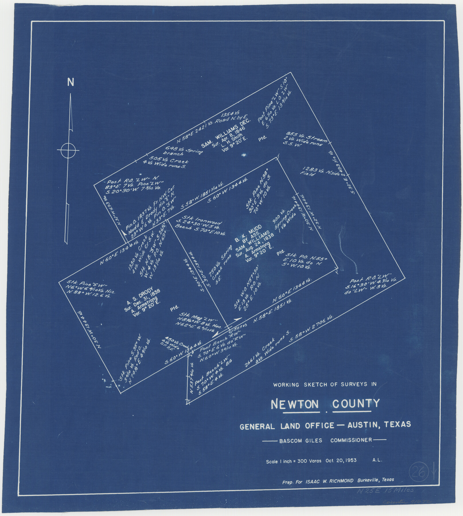
Newton County Working Sketch 26
-
Map/Doc
71272
-
Collection
General Map Collection
-
Object Dates
10/20/1953 (Creation Date)
-
Counties
Newton
-
Subjects
Surveying Working Sketch
-
Height x Width
18.3 x 16.4 inches
46.5 x 41.7 cm
-
Scale
1" = 300 varas
Part of: General Map Collection
Yoakum County Rolled Sketch 2

Print $20.00
- Digital $50.00
Yoakum County Rolled Sketch 2
1943
Size 18.6 x 33.4 inches
Map/Doc 8288
Montgomery County Sketch File 20

Print $38.00
- Digital $50.00
Montgomery County Sketch File 20
1932
Size 14.3 x 8.8 inches
Map/Doc 31847
Flight Mission No. BQY-14M, Frame 184, Harris County

Print $20.00
- Digital $50.00
Flight Mission No. BQY-14M, Frame 184, Harris County
1953
Size 18.6 x 22.4 inches
Map/Doc 85300
Overlay For Flight Mission No. BRE-2P, Frame 110 of H. A. Pierce Corrected Survey, December 21, 1950 of Cyrus Egery Survey of June 15, 1855

Print $20.00
- Digital $50.00
Overlay For Flight Mission No. BRE-2P, Frame 110 of H. A. Pierce Corrected Survey, December 21, 1950 of Cyrus Egery Survey of June 15, 1855
1956
Size 18.3 x 20.4 inches
Map/Doc 86795
Clay County Boundary File 15

Print $8.00
- Digital $50.00
Clay County Boundary File 15
Size 13.3 x 8.2 inches
Map/Doc 51418
Brewster County Sketch File N-29

Print $6.00
- Digital $50.00
Brewster County Sketch File N-29
1969
Size 14.1 x 8.8 inches
Map/Doc 15705
Parker County

Print $20.00
- Digital $50.00
Parker County
1942
Size 47.7 x 38.9 inches
Map/Doc 95609
Jim Hogg County Working Sketch 5

Print $20.00
- Digital $50.00
Jim Hogg County Working Sketch 5
1941
Size 40.8 x 41.0 inches
Map/Doc 66591
Zavala County Working Sketch 8

Print $20.00
- Digital $50.00
Zavala County Working Sketch 8
1949
Size 24.2 x 17.6 inches
Map/Doc 62083
[Surveys along the Texas coast across from Mustang Island]
![346, [Surveys along the Texas coast across from Mustang Island], General Map Collection](https://historictexasmaps.com/wmedia_w700/maps/346.tif.jpg)
Print $2.00
- Digital $50.00
[Surveys along the Texas coast across from Mustang Island]
1841
Size 11.3 x 7.3 inches
Map/Doc 346
Hall County Sketch File 21

Print $20.00
- Digital $50.00
Hall County Sketch File 21
1906
Size 12.8 x 15.8 inches
Map/Doc 11610
Ward County Rolled Sketch 14

Print $20.00
- Digital $50.00
Ward County Rolled Sketch 14
1940
Size 18.5 x 26.2 inches
Map/Doc 8157
You may also like
Liberty County Sketch File 50

Print $42.00
- Digital $50.00
Liberty County Sketch File 50
1879
Size 12.6 x 8.4 inches
Map/Doc 30014
Intracoastal Waterway in Texas - Corpus Christi to Point Isabel including Arroyo Colorado to Mo. Pac. R.R. Bridge Near Harlingen

Print $20.00
- Digital $50.00
Intracoastal Waterway in Texas - Corpus Christi to Point Isabel including Arroyo Colorado to Mo. Pac. R.R. Bridge Near Harlingen
1933
Size 27.5 x 40.6 inches
Map/Doc 61869
Bexar County Sketch File 55

Print $20.00
- Digital $50.00
Bexar County Sketch File 55
1838
Size 13.3 x 8.3 inches
Map/Doc 14560
Cochran County, Texas

Print $40.00
- Digital $50.00
Cochran County, Texas
Size 38.1 x 48.3 inches
Map/Doc 89870
Young County Working Sketch Graphic Index

Print $20.00
- Digital $50.00
Young County Working Sketch Graphic Index
1941
Size 44.1 x 38.4 inches
Map/Doc 76748
Mason County, Texas

Print $20.00
- Digital $50.00
Mason County, Texas
1896
Size 34.6 x 32.8 inches
Map/Doc 392
[Map of the Fort Worth & Denver City Railway, Hartley County, Texas]
![64389, [Map of the Fort Worth & Denver City Railway, Hartley County, Texas], General Map Collection](https://historictexasmaps.com/wmedia_w700/maps/64389.tif.jpg)
Print $40.00
- Digital $50.00
[Map of the Fort Worth & Denver City Railway, Hartley County, Texas]
1887
Size 22.0 x 120.7 inches
Map/Doc 64389
Karte des Staates, Texas

Print $20.00
Karte des Staates, Texas
1851
Size 27.2 x 30.1 inches
Map/Doc 76262
Map of east part of West Bay & SW part of Galveston Bay, Galveston County showing subdivision for mineral development

Print $40.00
- Digital $50.00
Map of east part of West Bay & SW part of Galveston Bay, Galveston County showing subdivision for mineral development
1963
Size 64.1 x 45.4 inches
Map/Doc 3079
Bee County Boundary File 5

Print $12.00
- Digital $50.00
Bee County Boundary File 5
Size 9.1 x 9.0 inches
Map/Doc 50452
Map of Hopkins Co.

Print $20.00
- Digital $50.00
Map of Hopkins Co.
1885
Size 36.6 x 38.7 inches
Map/Doc 4982
Floyd County Sketch File 27

Print $6.00
- Digital $50.00
Floyd County Sketch File 27
1900
Size 14.4 x 8.9 inches
Map/Doc 22789