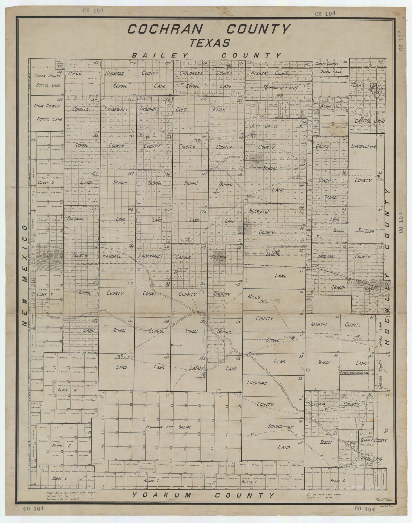
Cochran County, Texas
CO104
-
Map/Doc
89870
-
Collection
Twichell Survey Records
-
Counties
Cochran
-
Subjects
County
-
Height x Width
38.1 x 48.3 inches
96.8 x 122.7 cm
Part of: Twichell Survey Records
Glasscock Public Roads

Print $20.00
- Digital $50.00
Glasscock Public Roads
Size 38.3 x 36.8 inches
Map/Doc 89944
[Township 3 North, Blocks 33 and 34, T. & P. RR. Company]
![92626, [Township 3 North, Blocks 33 and 34, T. & P. RR. Company], Twichell Survey Records](https://historictexasmaps.com/wmedia_w700/maps/92626-1.tif.jpg)
Print $20.00
- Digital $50.00
[Township 3 North, Blocks 33 and 34, T. & P. RR. Company]
Size 22.1 x 16.2 inches
Map/Doc 92626
[North line of T. & P. Block 31, Township 6N]
![90554, [North line of T. & P. Block 31, Township 6N], Twichell Survey Records](https://historictexasmaps.com/wmedia_w700/maps/90554-1.tif.jpg)
Print $2.00
- Digital $50.00
[North line of T. & P. Block 31, Township 6N]
Size 7.5 x 4.7 inches
Map/Doc 90554
[Sketch highlighting Bob Reid and Fred Turner surveys]
![91692, [Sketch highlighting Bob Reid and Fred Turner surveys], Twichell Survey Records](https://historictexasmaps.com/wmedia_w700/maps/91692-1.tif.jpg)
Print $2.00
- Digital $50.00
[Sketch highlighting Bob Reid and Fred Turner surveys]
Size 5.9 x 7.6 inches
Map/Doc 91692
Subdivision of Tract 2, Soash-White Industrial Addition, Part of Southeast Quarter, Section 2, Block E (Geo. W. Soash - J. B. White, Owners)

Print $20.00
- Digital $50.00
Subdivision of Tract 2, Soash-White Industrial Addition, Part of Southeast Quarter, Section 2, Block E (Geo. W. Soash - J. B. White, Owners)
1956
Size 22.8 x 17.6 inches
Map/Doc 92775
[H. & T. C. Block 46]
![92980, [H. & T. C. Block 46], Twichell Survey Records](https://historictexasmaps.com/wmedia_w700/maps/92980-1.tif.jpg)
Print $20.00
- Digital $50.00
[H. & T. C. Block 46]
Size 28.5 x 17.9 inches
Map/Doc 92980
Working Sketch Crockett County

Print $20.00
- Digital $50.00
Working Sketch Crockett County
1924
Size 33.3 x 37.6 inches
Map/Doc 90318

[PSL Block A-12]
![93229, [PSL Block A-12], Twichell Survey Records](https://historictexasmaps.com/wmedia_w700/maps/93229-1.tif.jpg)
Print $2.00
- Digital $50.00
[PSL Block A-12]
1953
Size 8.7 x 13.5 inches
Map/Doc 93229
League 206, Ochiltree County School Land, Bailey and Lamb Counties, Texas

Print $20.00
- Digital $50.00
League 206, Ochiltree County School Land, Bailey and Lamb Counties, Texas
1954
Size 36.9 x 25.0 inches
Map/Doc 92537
Map showing lands surveyed by Sylvan Sanders in the Southwestern Part of Jack County, Texas for Buttram Petroleum Corporation

Print $20.00
- Digital $50.00
Map showing lands surveyed by Sylvan Sanders in the Southwestern Part of Jack County, Texas for Buttram Petroleum Corporation
1926
Size 29.3 x 25.6 inches
Map/Doc 92159
[John S. Stephens Blk. S2, Lgs. 174-177, 186-193, 201-209]
![89984, [John S. Stephens Blk. S2, Lgs. 174-177, 186-193, 201-209], Twichell Survey Records](https://historictexasmaps.com/wmedia_w700/maps/89984-1.tif.jpg)
Print $2.00
- Digital $50.00
[John S. Stephens Blk. S2, Lgs. 174-177, 186-193, 201-209]
1912
Size 11.4 x 8.8 inches
Map/Doc 89984
You may also like

Dietzgen Globe Wooden 24" T Square

Dietzgen Globe Wooden 24" T Square
Size 26.0 x 9.3 inches
Map/Doc 97324
Wharton County Working Sketch 18

Print $20.00
- Digital $50.00
Wharton County Working Sketch 18
1948
Size 19.3 x 17.0 inches
Map/Doc 72482
[St. Louis & Southwestern]
![64281, [St. Louis & Southwestern], General Map Collection](https://historictexasmaps.com/wmedia_w700/maps/64281.tif.jpg)
Print $20.00
- Digital $50.00
[St. Louis & Southwestern]
Size 20.9 x 29.0 inches
Map/Doc 64281
Harris County Working Sketch 128

Print $20.00
- Digital $50.00
Harris County Working Sketch 128
1996
Size 15.0 x 14.0 inches
Map/Doc 66020
Location Map of Chicago, Rock Island & Texas Railroad

Print $20.00
- Digital $50.00
Location Map of Chicago, Rock Island & Texas Railroad
Size 21.3 x 45.9 inches
Map/Doc 64473
[Plainview with Highland Addition]
![92662, [Plainview with Highland Addition], Twichell Survey Records](https://historictexasmaps.com/wmedia_w700/maps/92662-1.tif.jpg)
Print $40.00
- Digital $50.00
[Plainview with Highland Addition]
Size 54.0 x 27.4 inches
Map/Doc 92662
Real County Rolled Sketch 18

Print $20.00
- Digital $50.00
Real County Rolled Sketch 18
Size 21.2 x 27.7 inches
Map/Doc 7465
Coke County Working Sketch 24

Print $20.00
- Digital $50.00
Coke County Working Sketch 24
1956
Size 28.7 x 31.1 inches
Map/Doc 68061
Coke County Rolled Sketch 8

Print $20.00
- Digital $50.00
Coke County Rolled Sketch 8
Size 26.5 x 34.8 inches
Map/Doc 5507
Ward County Rolled Sketch 10

Print $20.00
- Digital $50.00
Ward County Rolled Sketch 10
1936
Size 24.4 x 35.7 inches
Map/Doc 8155
Sabine County Sketch File 9

Print $6.00
Sabine County Sketch File 9
1912
Size 12.7 x 8.0 inches
Map/Doc 35624