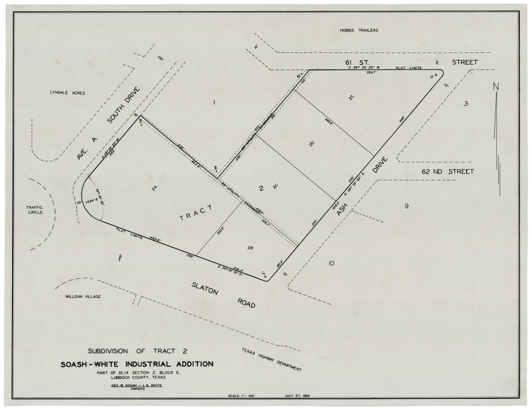
Subdivision of Tract 2, Soash-White Industrial Addition, Part of Southeast Quarter, Section 2, Block E (Geo. W. Soash - J. B. White, Owners)
-
Map/Doc
92775
-
Collection
Twichell Survey Records
-
Object Dates
7/27/1956 (Creation Date)
-
People and Organizations
[John N. Cinelli] (Surveyor/Engineer)
-
Counties
Lubbock
-
Height x Width
22.8 x 17.6 inches
57.9 x 44.7 cm
Part of: Twichell Survey Records
[North part of PSL Block A-19 and adjoining School Land Leagues]
![93024, [North part of PSL Block A-19 and adjoining School Land Leagues], Twichell Survey Records](https://historictexasmaps.com/wmedia_w700/maps/93024-1.tif.jpg)
Print $20.00
- Digital $50.00
[North part of PSL Block A-19 and adjoining School Land Leagues]
Size 23.5 x 19.1 inches
Map/Doc 93024
Working Sketch in Crosby Co.

Print $20.00
- Digital $50.00
Working Sketch in Crosby Co.
1906
Size 17.5 x 17.9 inches
Map/Doc 90350
[North Central Part of County]
![90812, [North Central Part of County], Twichell Survey Records](https://historictexasmaps.com/wmedia_w700/maps/90812-2.tif.jpg)
Print $20.00
- Digital $50.00
[North Central Part of County]
1902
Size 21.0 x 28.3 inches
Map/Doc 90812
[Leagues 116 through 161, Leagues 165, 181, and 182]
![92484, [Leagues 116 through 161, Leagues 165, 181, and 182], Twichell Survey Records](https://historictexasmaps.com/wmedia_w700/maps/92484-1.tif.jpg)
Print $20.00
- Digital $50.00
[Leagues 116 through 161, Leagues 165, 181, and 182]
Size 17.8 x 23.7 inches
Map/Doc 92484
[Sections Q, L Tech Memorial Park]
![92303, [Sections Q, L Tech Memorial Park], Twichell Survey Records](https://historictexasmaps.com/wmedia_w700/maps/92303-1.tif.jpg)
Print $20.00
- Digital $50.00
[Sections Q, L Tech Memorial Park]
1956
Size 13.0 x 17.8 inches
Map/Doc 92303
Highway Addition to Littlefield, Texas

Print $3.00
- Digital $50.00
Highway Addition to Littlefield, Texas
Size 14.3 x 11.7 inches
Map/Doc 92266
Plat showing proposed Water Permit on Cow Bayou in Orange County, Texas

Print $20.00
- Digital $50.00
Plat showing proposed Water Permit on Cow Bayou in Orange County, Texas
1922
Size 24.3 x 16.4 inches
Map/Doc 93017
Andrews County

Print $40.00
- Digital $50.00
Andrews County
1925
Size 56.5 x 42.8 inches
Map/Doc 89866
[Blocks S and M19 Resurvey]
![91440, [Blocks S and M19 Resurvey], Twichell Survey Records](https://historictexasmaps.com/wmedia_w700/maps/91440-1.tif.jpg)
Print $20.00
- Digital $50.00
[Blocks S and M19 Resurvey]
1903
Size 37.0 x 30.0 inches
Map/Doc 91440
[H. & T. C. , Block 47, Sections 26- 38]
![91255, [H. & T. C. , Block 47, Sections 26- 38], Twichell Survey Records](https://historictexasmaps.com/wmedia_w700/maps/91255-1.tif.jpg)
Print $2.00
- Digital $50.00
[H. & T. C. , Block 47, Sections 26- 38]
Size 14.5 x 9.2 inches
Map/Doc 91255
National Parks, Monuments and Shrines of the United States and Canada

National Parks, Monuments and Shrines of the United States and Canada
1958
Size 25.7 x 19.7 inches
Map/Doc 92377
[Blocks O5, O2, O, JD, A1, A2, A3, A4, B, T, D10, and vicinity]
![90717, [Blocks O5, O2, O, JD, A1, A2, A3, A4, B, T, D10, and vicinity], Twichell Survey Records](https://historictexasmaps.com/wmedia_w700/maps/90717-1.tif.jpg)
Print $20.00
- Digital $50.00
[Blocks O5, O2, O, JD, A1, A2, A3, A4, B, T, D10, and vicinity]
Size 34.7 x 29.3 inches
Map/Doc 90717
You may also like
Nueces County Sketch File 28

Print $6.00
- Digital $50.00
Nueces County Sketch File 28
Size 10.0 x 10.9 inches
Map/Doc 32596
[Sketch N, showing H. & G. N. Block 7, and Blocks C-1 through C-5]
![91768, [Sketch N, showing H. & G. N. Block 7, and Blocks C-1 through C-5], Twichell Survey Records](https://historictexasmaps.com/wmedia_w700/maps/91768-1.tif.jpg)
Print $20.00
- Digital $50.00
[Sketch N, showing H. & G. N. Block 7, and Blocks C-1 through C-5]
Size 14.6 x 16.7 inches
Map/Doc 91768
Flight Mission No. DCL-6C, Frame 132, Kenedy County

Print $20.00
- Digital $50.00
Flight Mission No. DCL-6C, Frame 132, Kenedy County
1943
Size 18.6 x 22.3 inches
Map/Doc 85962
Brown County Working Sketch 11

Print $20.00
- Digital $50.00
Brown County Working Sketch 11
1983
Size 45.5 x 43.1 inches
Map/Doc 67776
[University Lands Blocks 16, 18, 19 and 20]
![91593, [University Lands Blocks 16, 18, 19 and 20], Twichell Survey Records](https://historictexasmaps.com/wmedia_w700/maps/91593-1.tif.jpg)
Print $3.00
- Digital $50.00
[University Lands Blocks 16, 18, 19 and 20]
Size 8.8 x 16.8 inches
Map/Doc 91593
Freestone County Working Sketch 31a

Print $20.00
- Digital $50.00
Freestone County Working Sketch 31a
1996
Size 25.4 x 31.9 inches
Map/Doc 69273
Throckmorton County Rolled Sketch 3A

Print $20.00
- Digital $50.00
Throckmorton County Rolled Sketch 3A
Size 30.7 x 37.4 inches
Map/Doc 7987
Presidio County Sketch File 76

Print $20.00
- Digital $50.00
Presidio County Sketch File 76
Size 22.0 x 18.3 inches
Map/Doc 11720
Taylor County, Texas

Print $20.00
- Digital $50.00
Taylor County, Texas
1890
Size 28.7 x 21.6 inches
Map/Doc 574
Armstrong County Sketch File A-12

Print $40.00
- Digital $50.00
Armstrong County Sketch File A-12
Size 41.3 x 18.5 inches
Map/Doc 10374
Street guide and metropolitan map of New Orleans [Verso]
![94199, Street guide and metropolitan map of New Orleans [Verso], General Map Collection](https://historictexasmaps.com/wmedia_w700/maps/94199.tif.jpg)
Street guide and metropolitan map of New Orleans [Verso]
1963
Size 18.3 x 27.1 inches
Map/Doc 94199
Val Verde County Sketch File D

Print $20.00
- Digital $50.00
Val Verde County Sketch File D
1899
Size 29.8 x 40.0 inches
Map/Doc 10422