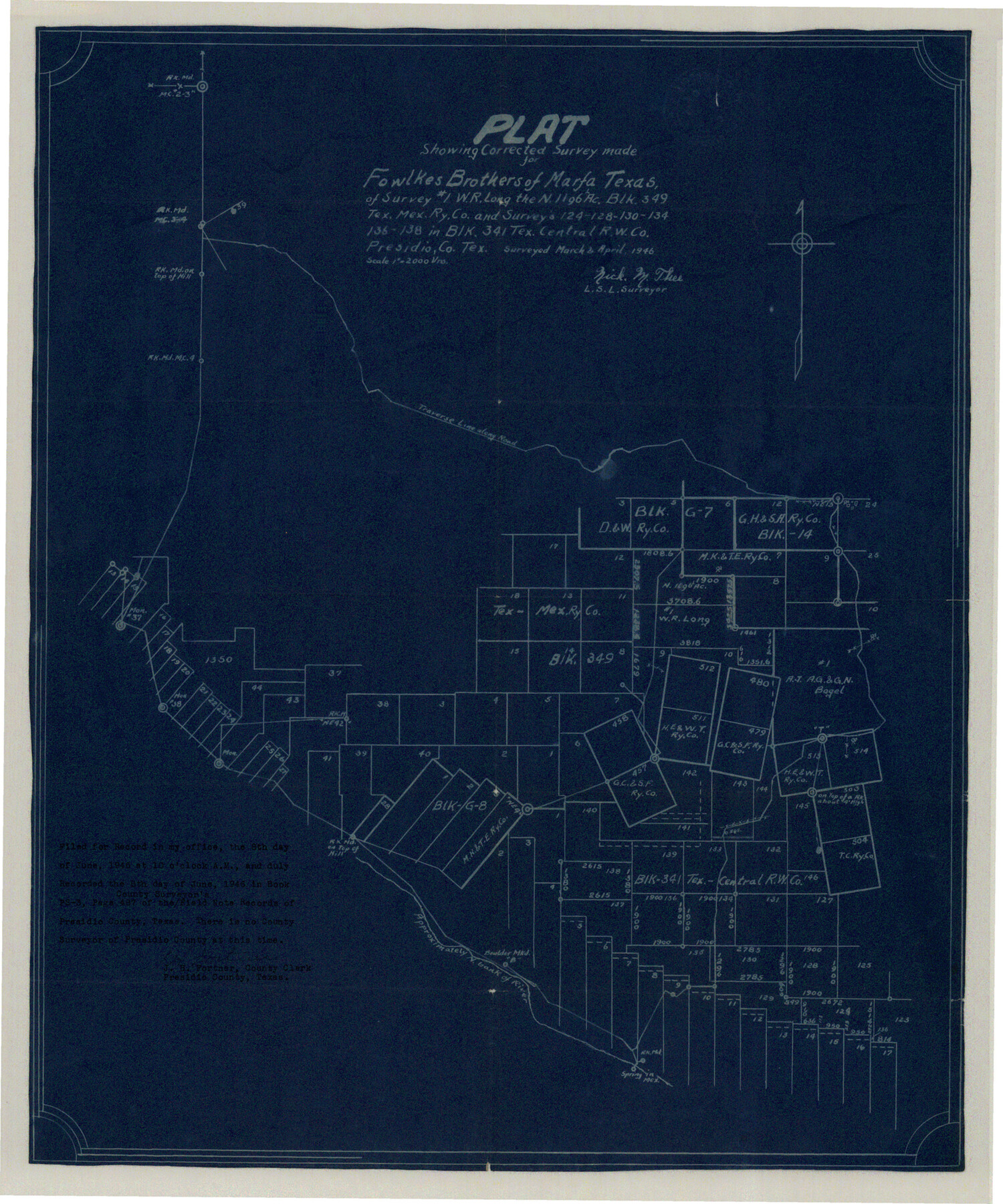
Presidio County Sketch File 76
Plat Showing Corrected Survey of Blocks 349 & 341, Tex. Mex RRCo., Presidio County, Texas
-
Map/Doc
11720
-
Collection
General Map Collection
-
Object Dates
7/19/1948 (File Date)
3/1946 (Survey Date)
4/1946 (Survey Date)
6/8/1946 (File Date)
-
People and Organizations
Nick M. Thee (Surveyor/Engineer)
-
Counties
Presidio
-
Subjects
Surveying Sketch File
-
Height x Width
22.0 x 18.3 inches
55.9 x 46.5 cm
-
Medium
blueprint/diazo
-
Scale
1" = 2000 varas
-
Comments
See Presidio County Sketch File 75 (34691) for report.
Related maps
Presidio County Sketch File 77

Print $20.00
- Digital $50.00
Presidio County Sketch File 77
Size 21.8 x 17.9 inches
Map/Doc 11721
Presidio County Sketch File 75

Print $30.00
- Digital $50.00
Presidio County Sketch File 75
1946
Size 8.9 x 14.3 inches
Map/Doc 34691
Part of: General Map Collection
Flight Mission No. DAG-28K, Frame 26, Matagorda County

Print $20.00
- Digital $50.00
Flight Mission No. DAG-28K, Frame 26, Matagorda County
1953
Size 18.5 x 22.3 inches
Map/Doc 86594
Starr County Rolled Sketch X

Print $121.00
- Digital $50.00
Starr County Rolled Sketch X
Size 13.3 x 8.1 inches
Map/Doc 75961
Hays County Working Sketch 5

Print $20.00
- Digital $50.00
Hays County Working Sketch 5
1929
Size 28.2 x 29.6 inches
Map/Doc 66079
Wharton County Working Sketch Graphic Index

Print $20.00
- Digital $50.00
Wharton County Working Sketch Graphic Index
1946
Size 41.7 x 47.5 inches
Map/Doc 76737
[Right of Way & Track Map, The Texas & Pacific Ry. Co. Main Line]
![64670, [Right of Way & Track Map, The Texas & Pacific Ry. Co. Main Line], General Map Collection](https://historictexasmaps.com/wmedia_w700/maps/64670.tif.jpg)
Print $20.00
- Digital $50.00
[Right of Way & Track Map, The Texas & Pacific Ry. Co. Main Line]
Size 11.0 x 18.5 inches
Map/Doc 64670
Coleman County Sketch File 20

Print $4.00
- Digital $50.00
Coleman County Sketch File 20
1871
Size 12.9 x 8.0 inches
Map/Doc 18694
Ward County State of Texas

Print $20.00
- Digital $50.00
Ward County State of Texas
1888
Size 22.6 x 26.0 inches
Map/Doc 4641
Johnson County Working Sketch 26

Print $20.00
- Digital $50.00
Johnson County Working Sketch 26
2005
Size 22.3 x 41.8 inches
Map/Doc 83574
Flight Mission No. CRK-3P, Frame 175, Refugio County

Print $20.00
- Digital $50.00
Flight Mission No. CRK-3P, Frame 175, Refugio County
1956
Size 18.6 x 21.7 inches
Map/Doc 86922
Crane County Sketch File 2

Print $6.00
- Digital $50.00
Crane County Sketch File 2
1873
Size 17.5 x 11.2 inches
Map/Doc 19557
Flight Mission No. DCL-7C, Frame 66, Kenedy County

Print $20.00
- Digital $50.00
Flight Mission No. DCL-7C, Frame 66, Kenedy County
1943
Size 15.5 x 15.3 inches
Map/Doc 86052
Donley County Sketch File 9

Print $4.00
- Digital $50.00
Donley County Sketch File 9
1884
Size 6.6 x 7.7 inches
Map/Doc 21238
You may also like
Coryell County Working Sketch 1

Print $20.00
- Digital $50.00
Coryell County Working Sketch 1
1906
Size 14.7 x 12.9 inches
Map/Doc 68208
Flight Mission No. CRC-4R, Frame 160, Chambers County

Print $20.00
- Digital $50.00
Flight Mission No. CRC-4R, Frame 160, Chambers County
1956
Size 18.5 x 22.3 inches
Map/Doc 84919
Crane County Boundary File 1b

Print $80.00
- Digital $50.00
Crane County Boundary File 1b
Size 85.1 x 17.9 inches
Map/Doc 51969
Taylor County Working Sketch 16

Print $20.00
- Digital $50.00
Taylor County Working Sketch 16
1981
Size 28.8 x 41.2 inches
Map/Doc 69626
![91112, [Block 1], Twichell Survey Records](https://historictexasmaps.com/wmedia_w700/maps/91112-1.tif.jpg)
Regni Mexicani seu Novae Hispaniae, Ludovicianae, N. Angliae, Carolinae, Virginiae, et Pennsylvaniae

Print $20.00
- Digital $50.00
Regni Mexicani seu Novae Hispaniae, Ludovicianae, N. Angliae, Carolinae, Virginiae, et Pennsylvaniae
1720
Size 22.5 x 26.5 inches
Map/Doc 93408
Working Sketch in Gray County

Print $3.00
- Digital $50.00
Working Sketch in Gray County
1903
Size 10.9 x 15.5 inches
Map/Doc 90753
Real County Working Sketch 40

Print $20.00
- Digital $50.00
Real County Working Sketch 40
1952
Size 31.5 x 22.5 inches
Map/Doc 71932
[Sketch of the Robertson League on the Brazos River showing a conflict with T.J. Chambers]
![3178, [Sketch of the Robertson League on the Brazos River showing a conflict with T.J. Chambers], General Map Collection](https://historictexasmaps.com/wmedia_w700/maps/3178.tif.jpg)
Print $2.00
- Digital $50.00
[Sketch of the Robertson League on the Brazos River showing a conflict with T.J. Chambers]
1841
Size 7.6 x 12.6 inches
Map/Doc 3178
Ward County Working Sketch 40

Print $20.00
- Digital $50.00
Ward County Working Sketch 40
1969
Size 24.4 x 45.7 inches
Map/Doc 72346
Colorado County Working Sketch 2

Print $20.00
- Digital $50.00
Colorado County Working Sketch 2
1904
Size 28.8 x 30.1 inches
Map/Doc 68102
Falls County Working Sketch 5

Print $40.00
- Digital $50.00
Falls County Working Sketch 5
2008
Size 34.3 x 56.6 inches
Map/Doc 88885