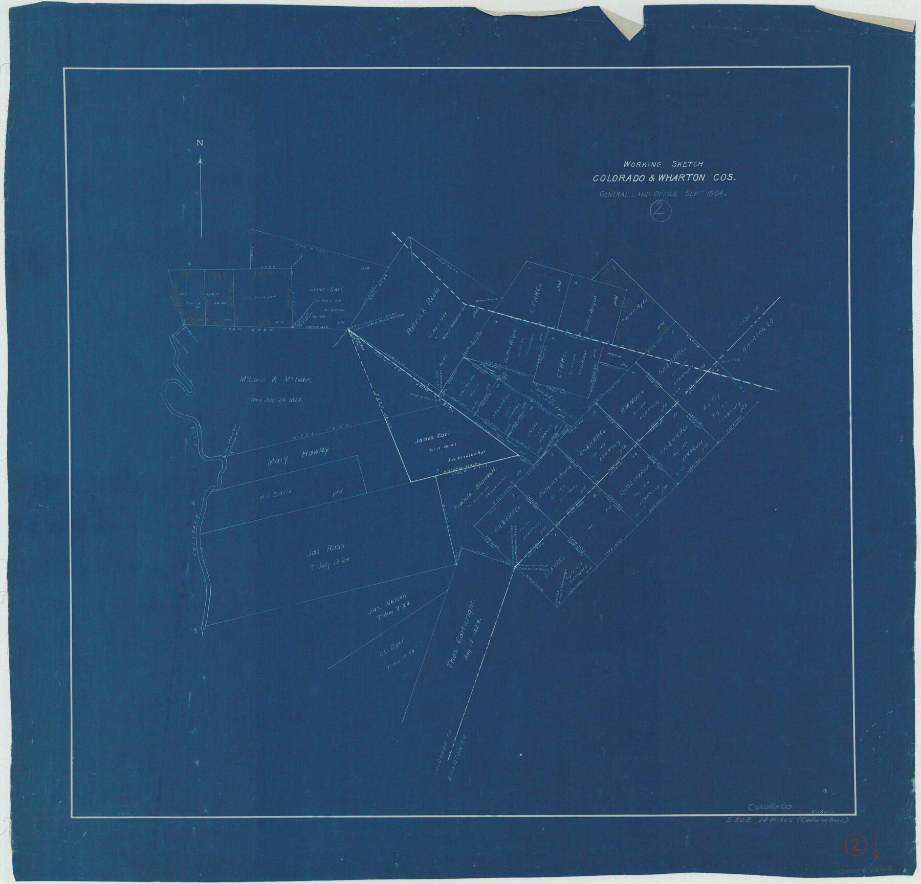
Colorado County Working Sketch 2
-
Map/Doc
68102
-
Collection
General Map Collection
-
Object Dates
9/1904 (Creation Date)
-
People and Organizations
Walter H. Walne (Draftsman)
-
Counties
Colorado Wharton
-
Subjects
Surveying Working Sketch
-
Height x Width
28.8 x 30.1 inches
73.2 x 76.5 cm
Part of: General Map Collection
Controlled Mosaic by Jack Amman Photogrammetric Engineers, Inc - Sheet 3

Print $20.00
- Digital $50.00
Controlled Mosaic by Jack Amman Photogrammetric Engineers, Inc - Sheet 3
1954
Size 20.0 x 24.0 inches
Map/Doc 83447
University Lands, Hudspeth County, Texas, Blocks A to N

Print $40.00
- Digital $50.00
University Lands, Hudspeth County, Texas, Blocks A to N
1935
Size 39.0 x 55.5 inches
Map/Doc 2413
Kaufman County Working Sketch 9

Print $20.00
- Digital $50.00
Kaufman County Working Sketch 9
1988
Size 35.9 x 29.8 inches
Map/Doc 66672
Dimmit County Sketch File 42

Print $2.00
- Digital $50.00
Dimmit County Sketch File 42
1901
Size 6.2 x 3.9 inches
Map/Doc 21171
Sutton County Working Sketch 37

Print $20.00
- Digital $50.00
Sutton County Working Sketch 37
1947
Size 31.0 x 41.4 inches
Map/Doc 62380
Blanco County Sketch File 32

Print $4.00
- Digital $50.00
Blanco County Sketch File 32
1888
Size 8.5 x 11.1 inches
Map/Doc 14633

Armstrong County Sketch File A-8

Print $80.00
- Digital $50.00
Armstrong County Sketch File A-8
Size 21.3 x 33.2 inches
Map/Doc 10850
San Augustine County Working Sketch 11a

Print $20.00
- Digital $50.00
San Augustine County Working Sketch 11a
Size 18.8 x 24.4 inches
Map/Doc 63698
Right of Way and Track Map, the Missouri, Kansas & Texas Ry. Of Texas operated by the Missouri, Kansas & Texas Ry. Of Texas, Houston Division

Print $40.00
- Digital $50.00
Right of Way and Track Map, the Missouri, Kansas & Texas Ry. Of Texas operated by the Missouri, Kansas & Texas Ry. Of Texas, Houston Division
1918
Size 25.6 x 62.5 inches
Map/Doc 64786
Angelina County Sketch File 15f

Print $4.00
- Digital $50.00
Angelina County Sketch File 15f
Size 10.4 x 7.6 inches
Map/Doc 12994
Travis County Working Sketch 58

Print $20.00
- Digital $50.00
Travis County Working Sketch 58
1946
Size 36.4 x 43.0 inches
Map/Doc 69442
You may also like
[Sketch filed with corrected field notes of Surveys 27, 28, 29 and 30, Block B-19, PSL]
![91848, [Sketch filed with corrected field notes of Surveys 27, 28, 29 and 30, Block B-19, PSL], Twichell Survey Records](https://historictexasmaps.com/wmedia_w700/maps/91848-1.tif.jpg)
Print $20.00
- Digital $50.00
[Sketch filed with corrected field notes of Surveys 27, 28, 29 and 30, Block B-19, PSL]
1943
Size 19.9 x 15.1 inches
Map/Doc 91848
Callahan County Working Sketch 12

Print $20.00
- Digital $50.00
Callahan County Working Sketch 12
1969
Size 25.6 x 38.5 inches
Map/Doc 67894
Leon County Working Sketch 35

Print $20.00
- Digital $50.00
Leon County Working Sketch 35
1978
Size 43.8 x 38.3 inches
Map/Doc 70434
Johnson County Boundary File 51

Print $66.00
- Digital $50.00
Johnson County Boundary File 51
Size 8.5 x 4.2 inches
Map/Doc 55589
Zapata County Working Sketch Graphic Index, Sheet 2 (Sketches 19 to Most Recent)

Print $40.00
- Digital $50.00
Zapata County Working Sketch Graphic Index, Sheet 2 (Sketches 19 to Most Recent)
1935
Size 55.6 x 41.5 inches
Map/Doc 76750

Travis County Rolled Sketch 59

Print $20.00
- Digital $50.00
Travis County Rolled Sketch 59
1987
Size 17.0 x 22.6 inches
Map/Doc 8050

The Republic County of Montgomery. December 29, 1845

Print $20.00
The Republic County of Montgomery. December 29, 1845
2020
Size 19.9 x 21.7 inches
Map/Doc 96241
Haskell County Sketch File 5

Print $4.00
- Digital $50.00
Haskell County Sketch File 5
1856
Size 10.1 x 8.1 inches
Map/Doc 26124
![90262, [Block M10], Twichell Survey Records](https://historictexasmaps.com/wmedia_w700/maps/90262-1.tif.jpg)
Sutton County Working Sketch Graphic Index, Sheet 2 (Sketches 25 to Most Recent)

Print $40.00
- Digital $50.00
Sutton County Working Sketch Graphic Index, Sheet 2 (Sketches 25 to Most Recent)
1941
Size 41.2 x 55.2 inches
Map/Doc 76706