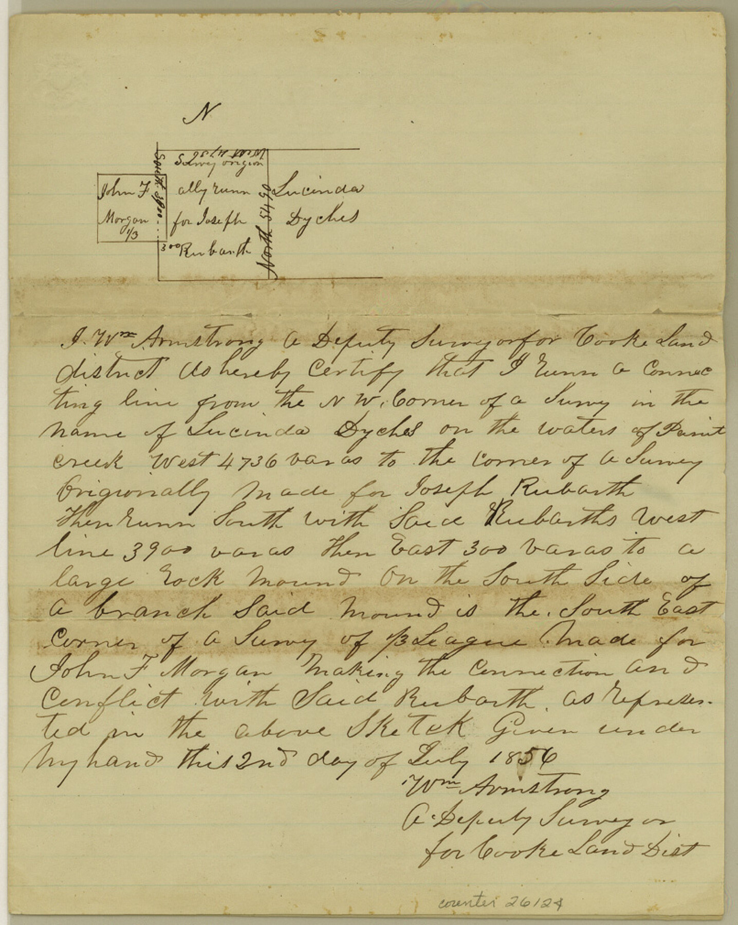
Haskell County Sketch File 5
[Sketch in southeast part of Haskell County]
-
Map/Doc
26124
-
Collection
General Map Collection
-
Object Dates
1856/7/25 (Creation Date)
1856/7/2 (Creation Date)
-
People and Organizations
William Armstrong (Surveyor/Engineer)
-
Counties
Haskell
-
Subjects
Surveying Sketch File
-
Height x Width
10.1 x 8.1 inches
25.7 x 20.6 cm
-
Medium
paper, manuscript
-
Features
Paint Creek
Otey's [sic] Creek
Part of: General Map Collection
Pecos County Working Sketch 131

Print $20.00
- Digital $50.00
Pecos County Working Sketch 131
1977
Size 27.8 x 21.1 inches
Map/Doc 71605
Hood County Working Sketch 12

Print $40.00
- Digital $50.00
Hood County Working Sketch 12
1978
Size 25.2 x 55.5 inches
Map/Doc 66206
Jefferson County Rolled Sketch 3

Print $20.00
- Digital $50.00
Jefferson County Rolled Sketch 3
1909
Size 36.0 x 16.2 inches
Map/Doc 6384
Flight Mission No. CGI-1N, Frame 181, Cameron County

Print $20.00
- Digital $50.00
Flight Mission No. CGI-1N, Frame 181, Cameron County
1955
Size 18.7 x 22.2 inches
Map/Doc 84516
Brewster County Working Sketch 22

Print $20.00
- Digital $50.00
Brewster County Working Sketch 22
1939
Size 18.4 x 30.7 inches
Map/Doc 67556
Aransas County NRC Article 33.136 Sketch 15

Print $42.00
- Digital $50.00
Aransas County NRC Article 33.136 Sketch 15
Size 24.0 x 36.0 inches
Map/Doc 95316

Brazoria County NRC Article 33.136 Sketch 11

Print $24.00
- Digital $50.00
Brazoria County NRC Article 33.136 Sketch 11
2012
Size 24.0 x 18.0 inches
Map/Doc 94777
Rio Grande, Brownsville Sheet No. 2

Print $4.00
- Digital $50.00
Rio Grande, Brownsville Sheet No. 2
1924
Size 21.2 x 28.3 inches
Map/Doc 65131
Flight Mission No. BRE-1P, Frame 57, Nueces County

Print $20.00
- Digital $50.00
Flight Mission No. BRE-1P, Frame 57, Nueces County
1956
Size 18.5 x 22.2 inches
Map/Doc 86646
Starr County Working Sketch 6

Print $20.00
- Digital $50.00
Starr County Working Sketch 6
Size 24.3 x 16.2 inches
Map/Doc 63922
Culberson County Sketch File RJ

Print $20.00
- Digital $50.00
Culberson County Sketch File RJ
1927
Size 16.9 x 24.4 inches
Map/Doc 5789
You may also like
Jack County Sketch File 10

Print $4.00
- Digital $50.00
Jack County Sketch File 10
1857
Size 12.4 x 8.3 inches
Map/Doc 27527
Kent County Boundary File 4a

Print $18.00
- Digital $50.00
Kent County Boundary File 4a
Size 14.2 x 8.5 inches
Map/Doc 55838

Williamson County Sketch File 9

Print $20.00
- Digital $50.00
Williamson County Sketch File 9
1850
Size 17.4 x 21.6 inches
Map/Doc 12692
Plat of 92 Surveys Containing 51,365 acres on the Main Brazos River, Texas ,Young Land District

Print $20.00
- Digital $50.00
Plat of 92 Surveys Containing 51,365 acres on the Main Brazos River, Texas ,Young Land District
1857
Size 23.4 x 31.0 inches
Map/Doc 551
[H. & T. C. Block 47]
![91833, [H. & T. C. Block 47], Twichell Survey Records](https://historictexasmaps.com/wmedia_w700/maps/91833-1.tif.jpg)
Print $20.00
- Digital $50.00
[H. & T. C. Block 47]
Size 24.8 x 16.0 inches
Map/Doc 91833
Flight Mission No. BRA-7M, Frame 37, Jefferson County

Print $20.00
- Digital $50.00
Flight Mission No. BRA-7M, Frame 37, Jefferson County
1953
Size 18.7 x 22.4 inches
Map/Doc 85488
Sketch I: Showing the Progress of the Survey in Section No. 9 [Galveston Bay]
![97133, Sketch I: Showing the Progress of the Survey in Section No. 9 [Galveston Bay], General Map Collection](https://historictexasmaps.com/wmedia_w700/maps/97133.tif.jpg)
Print $20.00
- Digital $50.00
Sketch I: Showing the Progress of the Survey in Section No. 9 [Galveston Bay]
1852
Size 9.4 x 13.4 inches
Map/Doc 97133
Bosque County Working Sketch 9

Print $20.00
- Digital $50.00
Bosque County Working Sketch 9
1943
Size 11.2 x 18.3 inches
Map/Doc 67442
Hays County Working Sketch 17

Print $20.00
- Digital $50.00
Hays County Working Sketch 17
1971
Size 28.6 x 30.0 inches
Map/Doc 66091
Archer County Sketch File 21

Print $40.00
- Digital $50.00
Archer County Sketch File 21
Size 30.3 x 19.8 inches
Map/Doc 10830
Plat of tract surveyed for S. W. Inglish

Print $20.00
- Digital $50.00
Plat of tract surveyed for S. W. Inglish
1920
Size 18.2 x 6.7 inches
Map/Doc 90822