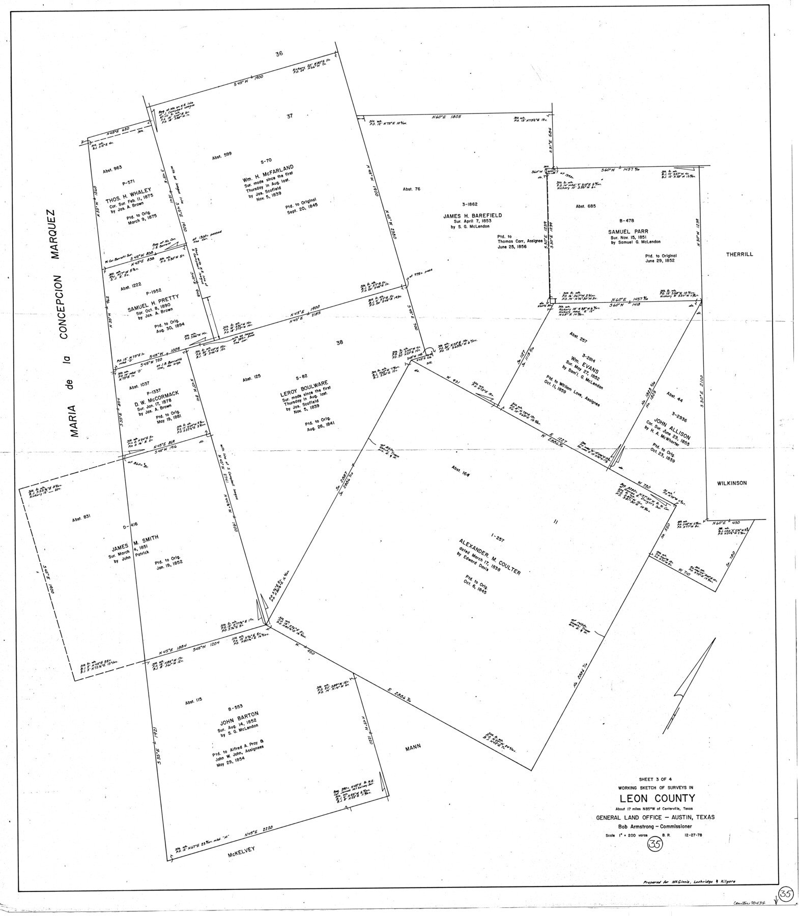
Leon County Working Sketch 35
-
Map/Doc
70434
-
Collection
General Map Collection
-
Object Dates
12/27/1978 (Creation Date)
-
People and Organizations
Beverly Robison (Draftsman)
-
Counties
Leon
-
Subjects
Surveying Working Sketch
-
Height x Width
43.8 x 38.3 inches
111.3 x 97.3 cm
-
Scale
1" = 200 varas
Part of: General Map Collection
Newton County Working Sketch 40

Print $20.00
- Digital $50.00
Newton County Working Sketch 40
1970
Size 43.6 x 39.7 inches
Map/Doc 71286
Galveston County NRC Article 33.136 Sketch 6

Print $20.00
- Digital $50.00
Galveston County NRC Article 33.136 Sketch 6
2001
Size 23.1 x 33.9 inches
Map/Doc 61588
Travis County Sketch File 43

Print $30.00
- Digital $50.00
Travis County Sketch File 43
1887
Size 8.8 x 9.3 inches
Map/Doc 38359
Jeff Davis County Working Sketch 35

Print $20.00
- Digital $50.00
Jeff Davis County Working Sketch 35
1979
Size 34.4 x 36.9 inches
Map/Doc 66530
Culberson County Sketch File 12a

Print $4.00
- Digital $50.00
Culberson County Sketch File 12a
1926
Size 14.3 x 8.8 inches
Map/Doc 20174
Denton County

Print $20.00
- Digital $50.00
Denton County
1947
Size 40.7 x 37.2 inches
Map/Doc 77262


San Jacinto County Rolled Sketch 15

Print $20.00
- Digital $50.00
San Jacinto County Rolled Sketch 15
2001
Size 19.2 x 25.2 inches
Map/Doc 7571
Map of Anderson County

Print $20.00
- Digital $50.00
Map of Anderson County
1876
Size 19.4 x 21.9 inches
Map/Doc 3228
Culberson County Working Sketch 60

Print $40.00
- Digital $50.00
Culberson County Working Sketch 60
1974
Size 74.7 x 32.7 inches
Map/Doc 68514
Flight Mission No. CUG-1P, Frame 78, Kleberg County

Print $20.00
- Digital $50.00
Flight Mission No. CUG-1P, Frame 78, Kleberg County
1956
Size 18.9 x 22.5 inches
Map/Doc 86143
You may also like
Corpus Christi Pass

Print $20.00
- Digital $50.00
Corpus Christi Pass
Size 46.2 x 41.4 inches
Map/Doc 78455
Map of North America engraved to illustrate Mitchell's school and family geography

Print $20.00
- Digital $50.00
Map of North America engraved to illustrate Mitchell's school and family geography
1839
Size 11.8 x 9.5 inches
Map/Doc 93493
Runnels County Working Sketch 8

Print $20.00
- Digital $50.00
Runnels County Working Sketch 8
1948
Size 38.4 x 37.1 inches
Map/Doc 63604
Flight Mission No. DQN-7K, Frame 32, Calhoun County

Print $20.00
- Digital $50.00
Flight Mission No. DQN-7K, Frame 32, Calhoun County
1953
Size 18.6 x 22.2 inches
Map/Doc 84470
Castro County

Print $20.00
- Digital $50.00
Castro County
1884
Size 12.6 x 16.1 inches
Map/Doc 90396
Moore County Rolled Sketch 15

Print $20.00
- Digital $50.00
Moore County Rolled Sketch 15
1981
Size 21.9 x 27.8 inches
Map/Doc 6832
Brazoria County Working Sketch 6

Print $20.00
- Digital $50.00
Brazoria County Working Sketch 6
1922
Size 16.8 x 24.0 inches
Map/Doc 67491
Map of the Texas & Pacific Railway "Gould System" Lines and Connections

Print $20.00
- Digital $50.00
Map of the Texas & Pacific Railway "Gould System" Lines and Connections
1890
Size 18.1 x 37.0 inches
Map/Doc 94102
Tyler County Sketch File 17a

Print $4.00
- Digital $50.00
Tyler County Sketch File 17a
1853
Size 6.6 x 8.0 inches
Map/Doc 38664
Newton County Sketch File 22

Print $4.00
- Digital $50.00
Newton County Sketch File 22
1890
Size 14.2 x 8.7 inches
Map/Doc 32401
Jackson County Rolled Sketch 14

Print $20.00
- Digital $50.00
Jackson County Rolled Sketch 14
1978
Size 28.3 x 37.0 inches
Map/Doc 6345
Pecos County Working Sketch 38

Print $20.00
- Digital $50.00
Pecos County Working Sketch 38
1939
Size 29.5 x 42.7 inches
Map/Doc 71510