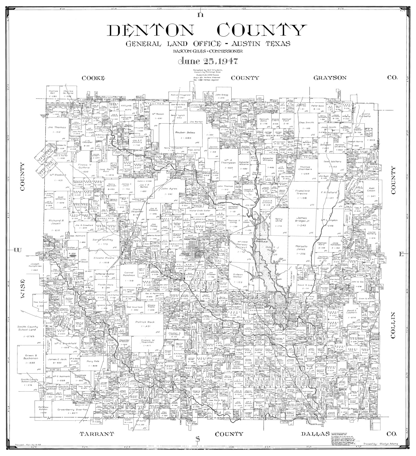
Denton County
-
Map/Doc
77262
-
Collection
General Map Collection
-
Object Dates
1947/6/25 (Creation Date)
-
People and Organizations
Tommye Buie (Draftsman)
R.C. Wisdom (Compiler)
-
Counties
Denton
-
Subjects
County
-
Height x Width
40.7 x 37.2 inches
103.4 x 94.5 cm
Part of: General Map Collection
Morris County Rolled Sketch 2A

Print $20.00
- Digital $50.00
Morris County Rolled Sketch 2A
Size 24.3 x 19.1 inches
Map/Doc 10239
Aransas Pass to Baffin Bay

Print $20.00
- Digital $50.00
Aransas Pass to Baffin Bay
1981
Size 43.0 x 35.0 inches
Map/Doc 73420
Jack County Boundary File 1

Print $26.00
- Digital $50.00
Jack County Boundary File 1
Size 12.9 x 8.2 inches
Map/Doc 55363
Nueces County Sketch File 44

Print $8.00
- Digital $50.00
Nueces County Sketch File 44
1953
Size 11.2 x 8.7 inches
Map/Doc 32637

Moore County Rolled Sketch 12

Print $20.00
- Digital $50.00
Moore County Rolled Sketch 12
1919
Size 24.9 x 22.7 inches
Map/Doc 6828
Map of Hamilton County

Print $20.00
- Digital $50.00
Map of Hamilton County
1872
Size 14.9 x 21.9 inches
Map/Doc 4556
Val Verde County Rolled Sketch 80

Print $20.00
- Digital $50.00
Val Verde County Rolled Sketch 80
1985
Size 16.3 x 20.1 inches
Map/Doc 8142
Map of Presidio County

Print $40.00
- Digital $50.00
Map of Presidio County
1895
Size 53.0 x 38.6 inches
Map/Doc 3968

[Scurry County]
![63030, [Scurry County], General Map Collection](https://historictexasmaps.com/wmedia_w700/maps/63030.tif.jpg)
Print $20.00
- Digital $50.00
[Scurry County]
1901
Size 34.3 x 42.5 inches
Map/Doc 63030
Lloyd's Map of the Southern States showing all the Railroads, their Stations & Distances, also the Counties, Towns, Villages, Harbors, Rivers, and Forts

Print $40.00
- Digital $50.00
Lloyd's Map of the Southern States showing all the Railroads, their Stations & Distances, also the Counties, Towns, Villages, Harbors, Rivers, and Forts
1861
Size 39.3 x 54.4 inches
Map/Doc 96556
You may also like
Llano County Working Sketch 5

Print $20.00
- Digital $50.00
Llano County Working Sketch 5
1961
Size 43.1 x 34.4 inches
Map/Doc 70623
Presidio County Rolled Sketch 86

Print $20.00
- Digital $50.00
Presidio County Rolled Sketch 86
1945
Size 34.1 x 27.8 inches
Map/Doc 7372
Jackson County Sketch File 6a

Print $30.00
- Digital $50.00
Jackson County Sketch File 6a
1894
Size 13.6 x 8.8 inches
Map/Doc 27634
Map of Wilson County

Print $20.00
- Digital $50.00
Map of Wilson County
1840
Size 24.4 x 21.0 inches
Map/Doc 4154
Upshur County Sketch File 12

Print $8.00
- Digital $50.00
Upshur County Sketch File 12
Size 10.3 x 8.0 inches
Map/Doc 38751
Edwards County Working Sketch 115

Print $20.00
- Digital $50.00
Edwards County Working Sketch 115
1973
Size 39.6 x 43.9 inches
Map/Doc 68991
Liberty County Sketch File 29

Print $40.00
- Digital $50.00
Liberty County Sketch File 29
1888
Size 14.9 x 14.9 inches
Map/Doc 29955
Flight Mission No. BRE-5P, Frame 191, Nueces County

Print $20.00
- Digital $50.00
Flight Mission No. BRE-5P, Frame 191, Nueces County
1956
Size 18.7 x 22.5 inches
Map/Doc 86837
Harris County Sketch File 99

Print $10.00
- Digital $50.00
Harris County Sketch File 99
1896
Size 14.5 x 8.9 inches
Map/Doc 25669
Yates Pool, Pecos County, Texas

Print $3.00
- Digital $50.00
Yates Pool, Pecos County, Texas
1928
Size 11.5 x 10.3 inches
Map/Doc 91674
Angelina County Working Sketch 10

Print $20.00
- Digital $50.00
Angelina County Working Sketch 10
1934
Size 35.0 x 36.9 inches
Map/Doc 67091
Flight Mission No. DAH-9M, Frame 197, Orange County

Print $20.00
- Digital $50.00
Flight Mission No. DAH-9M, Frame 197, Orange County
1953
Size 18.5 x 22.4 inches
Map/Doc 86865