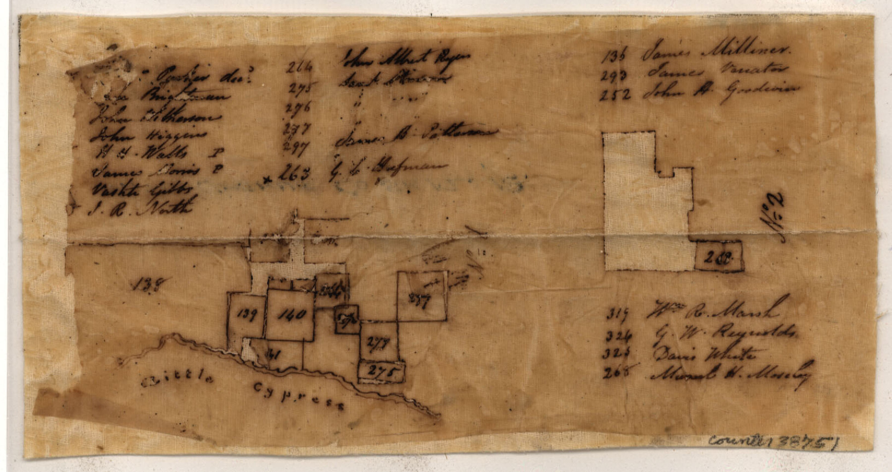
Upshur County Sketch File 12
[Multiple old sketches of surveys in the vicinity of Little Cypress Creek]
-
Map/Doc
38751
-
Collection
General Map Collection
-
People and Organizations
J.M. Glasco (Surveyor/Engineer)
-
Counties
Upshur
-
Subjects
Surveying Sketch File
-
Height x Width
10.3 x 8.0 inches
26.2 x 20.3 cm
-
Medium
paper, manuscript
-
Features
Little Cypress Creek
Part of: General Map Collection
Randall County Rolled Sketch 8

Print $20.00
- Digital $50.00
Randall County Rolled Sketch 8
Size 16.1 x 29.8 inches
Map/Doc 7430
Kimble County Working Sketch 25

Print $20.00
- Digital $50.00
Kimble County Working Sketch 25
1937
Size 22.9 x 22.7 inches
Map/Doc 70093
Burnet County Working Sketch 17

Print $20.00
- Digital $50.00
Burnet County Working Sketch 17
1979
Size 41.1 x 34.4 inches
Map/Doc 67860
Flight Mission No. DQN-5K, Frame 48, Calhoun County

Print $20.00
- Digital $50.00
Flight Mission No. DQN-5K, Frame 48, Calhoun County
1953
Size 18.7 x 22.2 inches
Map/Doc 84393
Bandera County

Print $40.00
- Digital $50.00
Bandera County
1904
Size 30.7 x 61.0 inches
Map/Doc 3274
Lubbock County Boundary File 5

Print $2.00
- Digital $50.00
Lubbock County Boundary File 5
Size 7.2 x 8.2 inches
Map/Doc 56493
[Texas Panhandle North Boundary Line]

Print $20.00
- Digital $50.00
[Texas Panhandle North Boundary Line]
1898
Size 11.9 x 46.1 inches
Map/Doc 1737
Brazoria County NRC Article 33.136 Sketch 30

Print $24.00
Brazoria County NRC Article 33.136 Sketch 30
2025
Map/Doc 97475
[The S.K. Ry. of Texas, State Line to Pecos, Reeves Co., Texas]
![64161, [The S.K. Ry. of Texas, State Line to Pecos, Reeves Co., Texas], General Map Collection](https://historictexasmaps.com/wmedia_w700/maps/64161.tif.jpg)
Print $40.00
- Digital $50.00
[The S.K. Ry. of Texas, State Line to Pecos, Reeves Co., Texas]
1910
Size 19.2 x 120.9 inches
Map/Doc 64161
Haskell County Sketch File 13

Print $37.00
- Digital $50.00
Haskell County Sketch File 13
Size 8.1 x 4.0 inches
Map/Doc 26142
Flight Mission No. BRA-16M, Frame 102, Jefferson County

Print $20.00
- Digital $50.00
Flight Mission No. BRA-16M, Frame 102, Jefferson County
1953
Size 18.6 x 22.3 inches
Map/Doc 85714
Flight Mission No. DAG-21K, Frame 119, Matagorda County

Print $20.00
- Digital $50.00
Flight Mission No. DAG-21K, Frame 119, Matagorda County
1952
Size 18.6 x 22.5 inches
Map/Doc 86445
You may also like
Webb County Sketch File 44b-1

Print $20.00
- Digital $50.00
Webb County Sketch File 44b-1
1936
Size 29.0 x 18.0 inches
Map/Doc 12641
Bosque County Boundary File 1

Print $34.00
- Digital $50.00
Bosque County Boundary File 1
Size 10.7 x 8.2 inches
Map/Doc 50672
Acts of the Visit of the Royal Commissioners (sometimes referred to as the “Visita General”) - Laredo

Acts of the Visit of the Royal Commissioners (sometimes referred to as the “Visita General”) - Laredo
1797
Size 14.1 x 9.3 inches
Map/Doc 94256
Map of Wise County Texas

Print $20.00
- Digital $50.00
Map of Wise County Texas
1912
Size 31.3 x 28.8 inches
Map/Doc 4644
Pecos County Rolled Sketch 26A

Print $40.00
- Digital $50.00
Pecos County Rolled Sketch 26A
1890
Size 19.0 x 55.5 inches
Map/Doc 75934
Matagorda County NRC Article 33.136 Sketch 20

Print $106.00
Matagorda County NRC Article 33.136 Sketch 20
2024
Map/Doc 97425
Current Miscellaneous File 6

Print $4.00
- Digital $50.00
Current Miscellaneous File 6
Size 11.3 x 8.8 inches
Map/Doc 73731

Travis County Rolled Sketch 33

Print $20.00
- Digital $50.00
Travis County Rolled Sketch 33
Size 22.7 x 32.7 inches
Map/Doc 8034
Hockley County Sketch File 18

Print $40.00
- Digital $50.00
Hockley County Sketch File 18
1930
Size 18.9 x 8.6 inches
Map/Doc 26553
McMullen County Sketch File 47

Print $20.00
- Digital $50.00
McMullen County Sketch File 47
1989
Size 24.6 x 21.5 inches
Map/Doc 12066
Ochiltree County School Land League Number 204

Print $20.00
- Digital $50.00
Ochiltree County School Land League Number 204
1926
Size 20.8 x 13.7 inches
Map/Doc 92473