Austin County Sketch File 5

Print $40.00
- Digital $50.00
Austin County Sketch File 5
1885
Size: 47.7 x 24.6 inches
10319
Jackson County Sketch File 17

Print $20.00
- Digital $50.00
Jackson County Sketch File 17
1913
Size: 19.4 x 19.1 inches
11841
Jackson County Sketch File A2 (1)

Print $20.00
- Digital $50.00
Jackson County Sketch File A2 (1)
1899
Size: 18.2 x 22.5 inches
11848
Wharton County Sketch File 4

Print $20.00
- Digital $50.00
Wharton County Sketch File 4
Size: 26.9 x 16.2 inches
12659
Wharton County Sketch File 10a

Print $20.00
- Digital $50.00
Wharton County Sketch File 10a
Size: 11.0 x 19.0 inches
12660
Wharton County Sketch File 12

Print $20.00
- Digital $50.00
Wharton County Sketch File 12
Size: 18.9 x 23.3 inches
12661
Wharton County Sketch File 13a

Print $20.00
- Digital $50.00
Wharton County Sketch File 13a
1894
Size: 18.3 x 28.7 inches
12663
Wharton County Sketch File 15

Print $20.00
- Digital $50.00
Wharton County Sketch File 15
Size: 18.2 x 21.1 inches
12665
Wharton County Sketch File 22

Print $20.00
- Digital $50.00
Wharton County Sketch File 22
1911
Size: 20.1 x 15.4 inches
12666
Wharton County Sketch File 23

Print $20.00
- Digital $50.00
Wharton County Sketch File 23
Size: 19.3 x 19.9 inches
12667
Wharton County Sketch File 24

Print $20.00
- Digital $50.00
Wharton County Sketch File 24
1919
Size: 19.9 x 25.5 inches
12668
Wharton County Sketch File A1

Print $20.00
- Digital $50.00
Wharton County Sketch File A1
1895
Size: 15.6 x 36.4 inches
12669
Wharton County Sketch File A2

Print $32.00
- Digital $50.00
Wharton County Sketch File A2
1898
Size: 22.1 x 15.7 inches
12670
Wharton County Sketch File A3

Print $26.00
- Digital $50.00
Wharton County Sketch File A3
1899
Size: 18.2 x 18.6 inches
12671
Austin County Sketch File 14

Print $40.00
- Digital $50.00
Austin County Sketch File 14
Size: 18.8 x 8.8 inches
13880
[Surveys in Austin's Colony along the Colorado River]
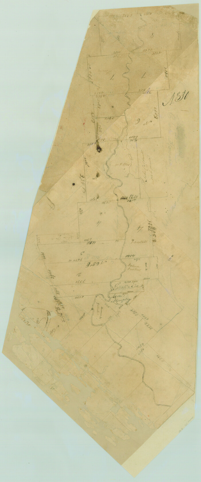
Print $20.00
- Digital $50.00
[Surveys in Austin's Colony along the Colorado River]
1830
Size: 30.5 x 12.7 inches
171
Colorado County Sketch File 16

Print $4.00
- Digital $50.00
Colorado County Sketch File 16
Size: 8.2 x 10.3 inches
18945
Colorado County Sketch File 25

Print $8.00
- Digital $50.00
Colorado County Sketch File 25
1919
Size: 11.5 x 8.8 inches
18963
[Surveys in Austin's Colony along the San Bernardo River, West Bernardo River, and Lone Tree Creek]
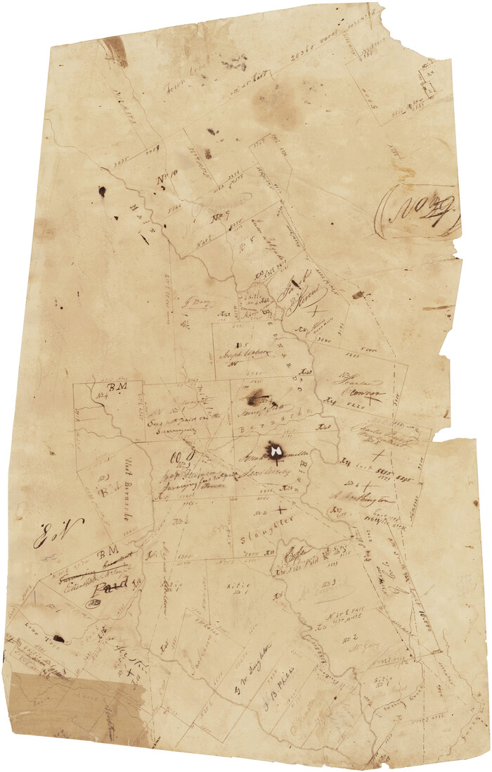
Print $20.00
- Digital $50.00
[Surveys in Austin's Colony along the San Bernardo River, West Bernardo River, and Lone Tree Creek]
1830
Size: 28.3 x 17.8 inches
194
Jackson County Sketch File 3

Print $34.00
- Digital $50.00
Jackson County Sketch File 3
1875
Size: 7.9 x 7.7 inches
27621
Matagorda County Sketch File 2

Print $6.00
- Digital $50.00
Matagorda County Sketch File 2
1866
Size: 15.9 x 10.8 inches
30730
Matagorda County Sketch File 11

Print $6.00
- Digital $50.00
Matagorda County Sketch File 11
1885
Size: 9.7 x 6.2 inches
30768
Matagorda County Sketch File 14

Print $40.00
- Digital $50.00
Matagorda County Sketch File 14
Size: 13.5 x 14.8 inches
30772
Matagorda County Sketch File 16

Print $4.00
- Digital $50.00
Matagorda County Sketch File 16
Size: 8.4 x 10.3 inches
30780
Wharton County Sketch File 1

Print $6.00
- Digital $50.00
Wharton County Sketch File 1
Size: 10.6 x 8.7 inches
39910
Wharton County Sketch File 2

Print $40.00
- Digital $50.00
Wharton County Sketch File 2
1875
Size: 13.6 x 12.6 inches
39913
Wharton County Sketch File 3

Print $4.00
- Digital $50.00
Wharton County Sketch File 3
1875
Size: 9.1 x 8.3 inches
39915
Wharton County Sketch File 3a

Print $4.00
- Digital $50.00
Wharton County Sketch File 3a
1875
Size: 6.8 x 4.6 inches
39917
Austin County Sketch File 5
Print $40.00
- Digital $50.00
Austin County Sketch File 5
1885
-
Size
47.7 x 24.6 inches
-
Map/Doc
10319
-
Creation Date
1885
Jackson County Sketch File 17
Print $20.00
- Digital $50.00
Jackson County Sketch File 17
1913
-
Size
19.4 x 19.1 inches
-
Map/Doc
11841
-
Creation Date
1913
Jackson County Sketch File A2 (1)
Print $20.00
- Digital $50.00
Jackson County Sketch File A2 (1)
1899
-
Size
18.2 x 22.5 inches
-
Map/Doc
11848
-
Creation Date
1899
Wharton County Sketch File 4
Print $20.00
- Digital $50.00
Wharton County Sketch File 4
-
Size
26.9 x 16.2 inches
-
Map/Doc
12659
Wharton County Sketch File 10a
Print $20.00
- Digital $50.00
Wharton County Sketch File 10a
-
Size
11.0 x 19.0 inches
-
Map/Doc
12660
Wharton County Sketch File 12
Print $20.00
- Digital $50.00
Wharton County Sketch File 12
-
Size
18.9 x 23.3 inches
-
Map/Doc
12661
Wharton County Sketch File 13a
Print $20.00
- Digital $50.00
Wharton County Sketch File 13a
1894
-
Size
18.3 x 28.7 inches
-
Map/Doc
12663
-
Creation Date
1894
Wharton County Sketch File 15
Print $20.00
- Digital $50.00
Wharton County Sketch File 15
-
Size
18.2 x 21.1 inches
-
Map/Doc
12665
Wharton County Sketch File 22
Print $20.00
- Digital $50.00
Wharton County Sketch File 22
1911
-
Size
20.1 x 15.4 inches
-
Map/Doc
12666
-
Creation Date
1911
Wharton County Sketch File 23
Print $20.00
- Digital $50.00
Wharton County Sketch File 23
-
Size
19.3 x 19.9 inches
-
Map/Doc
12667
Wharton County Sketch File 24
Print $20.00
- Digital $50.00
Wharton County Sketch File 24
1919
-
Size
19.9 x 25.5 inches
-
Map/Doc
12668
-
Creation Date
1919
Wharton County Sketch File A1
Print $20.00
- Digital $50.00
Wharton County Sketch File A1
1895
-
Size
15.6 x 36.4 inches
-
Map/Doc
12669
-
Creation Date
1895
Wharton County Sketch File A2
Print $32.00
- Digital $50.00
Wharton County Sketch File A2
1898
-
Size
22.1 x 15.7 inches
-
Map/Doc
12670
-
Creation Date
1898
Wharton County Sketch File A3
Print $26.00
- Digital $50.00
Wharton County Sketch File A3
1899
-
Size
18.2 x 18.6 inches
-
Map/Doc
12671
-
Creation Date
1899
Austin County Sketch File 14
Print $40.00
- Digital $50.00
Austin County Sketch File 14
-
Size
18.8 x 8.8 inches
-
Map/Doc
13880
Wharton Co.

Print $40.00
- Digital $50.00
Wharton Co.
1906
-
Size
48.6 x 43.8 inches
-
Map/Doc
16922
-
Creation Date
1906
Wharton County

Print $40.00
- Digital $50.00
Wharton County
1894
-
Size
52.3 x 56.3 inches
-
Map/Doc
16923
-
Creation Date
1894
[Surveys in Austin's Colony along the Colorado River]
Print $20.00
- Digital $50.00
[Surveys in Austin's Colony along the Colorado River]
1830
-
Size
30.5 x 12.7 inches
-
Map/Doc
171
-
Creation Date
1830
Colorado County Sketch File 16
Print $4.00
- Digital $50.00
Colorado County Sketch File 16
-
Size
8.2 x 10.3 inches
-
Map/Doc
18945
Colorado County Sketch File 25
Print $8.00
- Digital $50.00
Colorado County Sketch File 25
1919
-
Size
11.5 x 8.8 inches
-
Map/Doc
18963
-
Creation Date
1919
[Surveys in Austin's Colony along the San Bernardo River, West Bernardo River, and Lone Tree Creek]
Print $20.00
- Digital $50.00
[Surveys in Austin's Colony along the San Bernardo River, West Bernardo River, and Lone Tree Creek]
1830
-
Size
28.3 x 17.8 inches
-
Map/Doc
194
-
Creation Date
1830
Jackson County Sketch File 3
Print $34.00
- Digital $50.00
Jackson County Sketch File 3
1875
-
Size
7.9 x 7.7 inches
-
Map/Doc
27621
-
Creation Date
1875
Matagorda County Sketch File 2
Print $6.00
- Digital $50.00
Matagorda County Sketch File 2
1866
-
Size
15.9 x 10.8 inches
-
Map/Doc
30730
-
Creation Date
1866
Matagorda County Sketch File 11
Print $6.00
- Digital $50.00
Matagorda County Sketch File 11
1885
-
Size
9.7 x 6.2 inches
-
Map/Doc
30768
-
Creation Date
1885
Matagorda County Sketch File 14
Print $40.00
- Digital $50.00
Matagorda County Sketch File 14
-
Size
13.5 x 14.8 inches
-
Map/Doc
30772
Matagorda County Sketch File 16
Print $4.00
- Digital $50.00
Matagorda County Sketch File 16
-
Size
8.4 x 10.3 inches
-
Map/Doc
30780
Wharton County Sketch File 1
Print $6.00
- Digital $50.00
Wharton County Sketch File 1
-
Size
10.6 x 8.7 inches
-
Map/Doc
39910
Wharton County Sketch File 2
Print $40.00
- Digital $50.00
Wharton County Sketch File 2
1875
-
Size
13.6 x 12.6 inches
-
Map/Doc
39913
-
Creation Date
1875
Wharton County Sketch File 3
Print $4.00
- Digital $50.00
Wharton County Sketch File 3
1875
-
Size
9.1 x 8.3 inches
-
Map/Doc
39915
-
Creation Date
1875
Wharton County Sketch File 3a
Print $4.00
- Digital $50.00
Wharton County Sketch File 3a
1875
-
Size
6.8 x 4.6 inches
-
Map/Doc
39917
-
Creation Date
1875