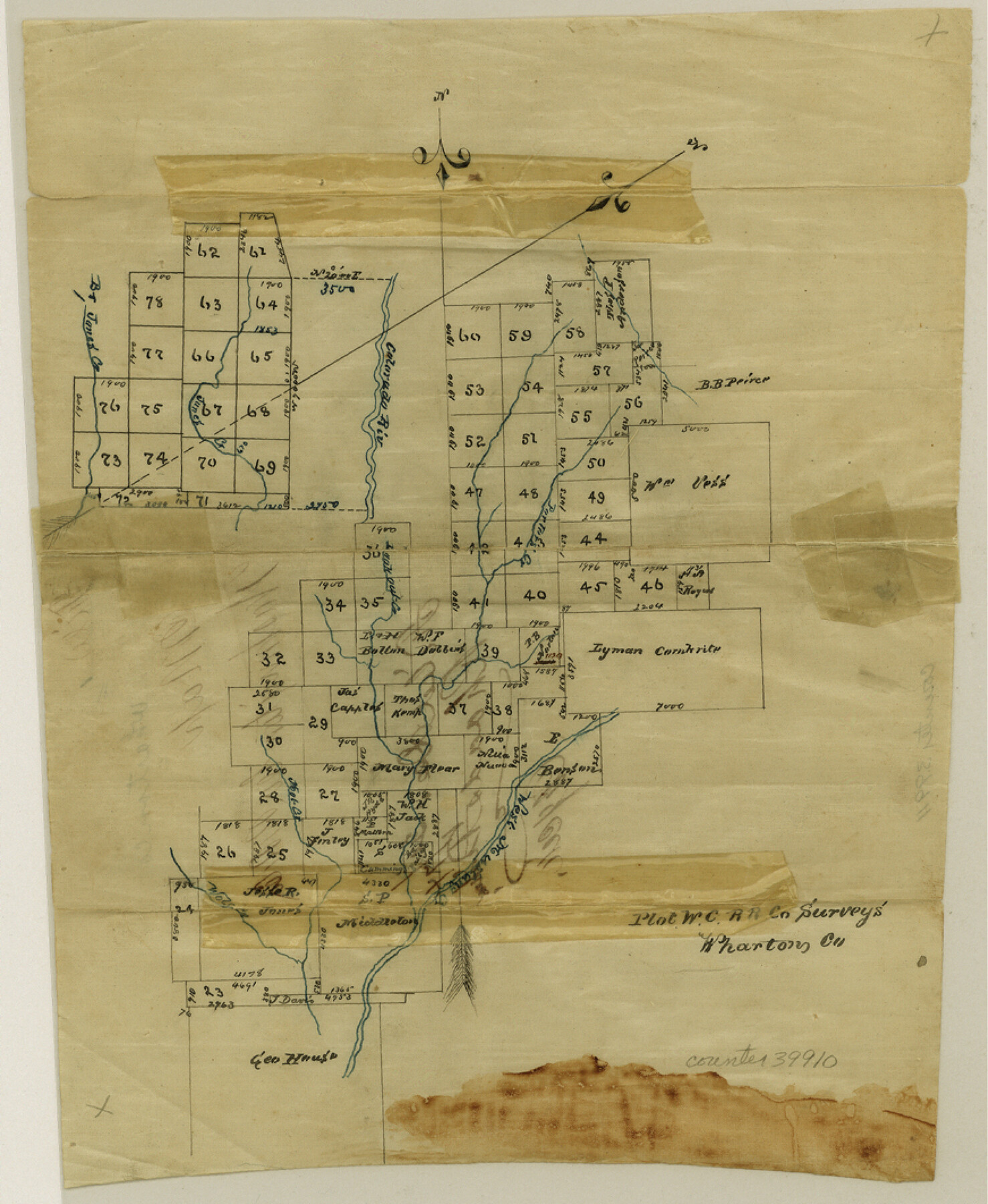
Wharton County Sketch File 1
[Sketches of W. C. R.R. Co. surveys in Wharton and Colorado Counties]
-
Map/Doc
39910
-
Collection
General Map Collection
-
Object Dates
12/31/1874 (File Date)
-
Counties
Wharton Colorado
-
Subjects
Surveying Sketch File
-
Height x Width
10.6 x 8.7 inches
26.9 x 22.1 cm
-
Medium
paper, manuscript
-
Features
Colorado River
Jones Creek
June's Creek
Partar's Creek
Lookout Creek
Hot Creek
Wolf Creek
West Mustang Creek
East Turkey Creek
Middle Creek
West Turkey Creek
Part of: General Map Collection
[Field book of Martin Duval, Wilbarger Co., H&TC RR Co. Blocks 13 & 14]
![61431, [Field book of Martin Duval, Wilbarger Co., H&TC RR Co. Blocks 13 & 14], General Map Collection](https://historictexasmaps.com/wmedia_w700/pdf_converted_jpg/qi_pdf_thumbnail_17161.jpg)
[Field book of Martin Duval, Wilbarger Co., H&TC RR Co. Blocks 13 & 14]
Size 6.7 x 8.2 inches
Map/Doc 61431
Upton County Rolled Sketch 31

Print $40.00
- Digital $50.00
Upton County Rolled Sketch 31
Size 27.2 x 53.4 inches
Map/Doc 10048
Limestone County Working Sketch 6

Print $20.00
- Digital $50.00
Limestone County Working Sketch 6
1922
Size 31.5 x 33.3 inches
Map/Doc 70556
Flight Mission No. BRE-2P, Frame 103, Nueces County

Print $20.00
- Digital $50.00
Flight Mission No. BRE-2P, Frame 103, Nueces County
1956
Size 18.5 x 22.2 inches
Map/Doc 86788
[Surveys along Trinity River]
![7, [Surveys along Trinity River], General Map Collection](https://historictexasmaps.com/wmedia_w700/maps/7.tif.jpg)
Print $20.00
- Digital $50.00
[Surveys along Trinity River]
1844
Size 21.4 x 12.6 inches
Map/Doc 7
Medina County Rolled Sketch 9

Print $20.00
- Digital $50.00
Medina County Rolled Sketch 9
Size 18.8 x 31.0 inches
Map/Doc 6743
Calhoun County NRC Article 33.136 Sketch 9

Print $106.00
- Digital $50.00
Calhoun County NRC Article 33.136 Sketch 9
2021
Map/Doc 96913
Brewster County Sketch File 22

Print $15.00
- Digital $50.00
Brewster County Sketch File 22
Size 15.7 x 10.8 inches
Map/Doc 15820
Andrews County Sketch File 10

Print $40.00
- Digital $50.00
Andrews County Sketch File 10
1950
Size 27.4 x 18.2 inches
Map/Doc 10810
Pecos County Rolled Sketch 125

Print $20.00
- Digital $50.00
Pecos County Rolled Sketch 125
1948
Size 32.0 x 41.6 inches
Map/Doc 7266
Terrell County Working Sketch 23

Print $20.00
- Digital $50.00
Terrell County Working Sketch 23
1940
Size 24.1 x 19.1 inches
Map/Doc 62173
[Surveys on San Antonio River and Aransas Bay area]
![141, [Surveys on San Antonio River and Aransas Bay area], General Map Collection](https://historictexasmaps.com/wmedia_w700/maps/141.tif.jpg)
Print $20.00
- Digital $50.00
[Surveys on San Antonio River and Aransas Bay area]
1840
Size 24.1 x 33.0 inches
Map/Doc 141
You may also like
Johnson County Working Sketch 7

Print $20.00
- Digital $50.00
Johnson County Working Sketch 7
1951
Size 23.0 x 21.3 inches
Map/Doc 66620
Chambers County Sketch File 15

Print $4.00
- Digital $50.00
Chambers County Sketch File 15
Size 8.3 x 12.4 inches
Map/Doc 17563

Hutchinson County Rolled Sketch 36B

Print $20.00
- Digital $50.00
Hutchinson County Rolled Sketch 36B
1888
Size 21.1 x 25.3 inches
Map/Doc 6295
[Portions of E. L. & R. R. and G. C. & S. F. Block 1]
![91337, [Portions of E. L. & R. R. and G. C. & S. F. Block 1], Twichell Survey Records](https://historictexasmaps.com/wmedia_w700/maps/91337-1.tif.jpg)
Print $3.00
- Digital $50.00
[Portions of E. L. & R. R. and G. C. & S. F. Block 1]
Size 9.7 x 15.2 inches
Map/Doc 91337
Travis County Rolled Sketch 19

Print $20.00
- Digital $50.00
Travis County Rolled Sketch 19
1940
Size 34.4 x 37.8 inches
Map/Doc 10012
Baylor County Sketch File 15

Print $6.00
- Digital $50.00
Baylor County Sketch File 15
1879
Size 13.0 x 8.4 inches
Map/Doc 14183
Chambers County Rolled Sketch 27

Print $40.00
- Digital $50.00
Chambers County Rolled Sketch 27
1944
Size 53.2 x 35.4 inches
Map/Doc 8619
Hunt County Sketch File 32

Print $6.00
- Digital $50.00
Hunt County Sketch File 32
Size 7.9 x 11.6 inches
Map/Doc 27138

Jasper County Rolled Sketch 5

Print $20.00
- Digital $50.00
Jasper County Rolled Sketch 5
1948
Size 29.0 x 24.4 inches
Map/Doc 6352
Ector County Rolled Sketch WA

Print $20.00
- Digital $50.00
Ector County Rolled Sketch WA
Size 26.2 x 30.0 inches
Map/Doc 5780