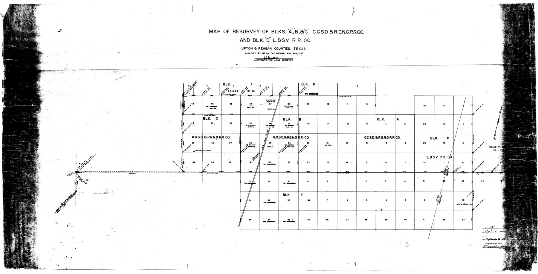
Upton County Rolled Sketch 31
Map of resurvey of Blks. "A", "B", & "C", C. C. S. D. & R. G. N. G. R.R. Co. and Blk. "D", L. & S. V. R.R. Co., Upton & Reagan Counties, Texas
-
Map/Doc
10048
-
Collection
General Map Collection
-
Object Dates
1950 (Survey Date)
1950/9/25 (File Date)
-
People and Organizations
J.A. Simpson (Surveyor/Engineer)
-
Counties
Upton Reagan
-
Subjects
Surveying Rolled Sketch
-
Height x Width
27.2 x 53.4 inches
69.1 x 135.6 cm
Part of: General Map Collection
Brown County Working Sketch 6

Print $20.00
- Digital $50.00
Brown County Working Sketch 6
1948
Size 12.9 x 19.3 inches
Map/Doc 67771

Geological Highway Map of Texas

Geological Highway Map of Texas
1973
Size 28.4 x 36.2 inches
Map/Doc 74356
Amistad International Reservoir on Rio Grande 102

Print $20.00
- Digital $50.00
Amistad International Reservoir on Rio Grande 102
1950
Size 28.5 x 41.2 inches
Map/Doc 75533
Crockett County Sketch File 51

Print $16.00
- Digital $50.00
Crockett County Sketch File 51
Size 10.1 x 9.1 inches
Map/Doc 19799

Flight Mission No. CGI-3N, Frame 167, Cameron County

Print $20.00
- Digital $50.00
Flight Mission No. CGI-3N, Frame 167, Cameron County
1954
Size 18.6 x 22.4 inches
Map/Doc 84631
Hardeman County

Print $20.00
- Digital $50.00
Hardeman County
1935
Size 44.4 x 41.4 inches
Map/Doc 73170
Hockley County Boundary File 6

Print $446.00
- Digital $50.00
Hockley County Boundary File 6
Size 3.1 x 5.1 inches
Map/Doc 54832
[Maps of surveys in Reeves & Culberson Cos]
![61141, [Maps of surveys in Reeves & Culberson Cos], General Map Collection](https://historictexasmaps.com/wmedia_w700/maps/61141.tif.jpg)
Print $20.00
- Digital $50.00
[Maps of surveys in Reeves & Culberson Cos]
1937
Size 30.7 x 24.9 inches
Map/Doc 61141
Refugio County Boundary File 4

Print $28.00
- Digital $50.00
Refugio County Boundary File 4
Size 14.0 x 8.8 inches
Map/Doc 58251
Cameron County Aerial Photograph Index Sheet 6

Print $20.00
- Digital $50.00
Cameron County Aerial Photograph Index Sheet 6
1955
Size 20.6 x 14.0 inches
Map/Doc 83678
You may also like
[Public School Land Blocks]
![93151, [Public School Land Blocks], Twichell Survey Records](https://historictexasmaps.com/wmedia_w700/maps/93151-1.tif.jpg)
Print $40.00
- Digital $50.00
[Public School Land Blocks]
Size 45.0 x 114.7 inches
Map/Doc 93151
Magnetic Declination in the United States - Epoch 1980

Print $20.00
- Digital $50.00
Magnetic Declination in the United States - Epoch 1980
1980
Size 41.3 x 33.2 inches
Map/Doc 92367
Cochran County Sketch File 5

Print $24.00
- Digital $50.00
Cochran County Sketch File 5
1932
Size 11.1 x 8.7 inches
Map/Doc 18542
Travis County Sketch File 45

Print $20.00
- Digital $50.00
Travis County Sketch File 45
1937
Size 22.7 x 37.8 inches
Map/Doc 12467
Pecos County Rolled Sketch 115A

Print $20.00
- Digital $50.00
Pecos County Rolled Sketch 115A
1943
Size 15.8 x 15.2 inches
Map/Doc 7258
[Surveys along the Cibolo, Balcones and Leon Creeks]
![37, [Surveys along the Cibolo, Balcones and Leon Creeks], General Map Collection](https://historictexasmaps.com/wmedia_w700/maps/37.tif.jpg)
Print $2.00
- Digital $50.00
[Surveys along the Cibolo, Balcones and Leon Creeks]
1841
Size 13.3 x 7.8 inches
Map/Doc 37
Flight Mission No. DCL-7C, Frame 56, Kenedy County

Print $20.00
- Digital $50.00
Flight Mission No. DCL-7C, Frame 56, Kenedy County
1943
Size 15.4 x 15.2 inches
Map/Doc 86044
[Sketch of surveys in Val Verde County]
![5048, [Sketch of surveys in Val Verde County], Maddox Collection](https://historictexasmaps.com/wmedia_w700/maps/5048.tif.jpg)
Print $20.00
- Digital $50.00
[Sketch of surveys in Val Verde County]
Size 17.3 x 17.1 inches
Map/Doc 5048
Wise County Sketch File 52

Print $20.00
- Digital $50.00
Wise County Sketch File 52
1982
Size 14.2 x 8.6 inches
Map/Doc 40619
General Highway Map, Jasper County, Texas

Print $20.00
General Highway Map, Jasper County, Texas
1961
Size 18.3 x 24.7 inches
Map/Doc 79535
Harris County Rolled Sketch P57

Print $20.00
- Digital $50.00
Harris County Rolled Sketch P57
1929
Size 29.6 x 37.5 inches
Map/Doc 9118
[Blocks 2, 3, 4, 7, and B2]
![90754, [Blocks 2, 3, 4, 7, and B2], Twichell Survey Records](https://historictexasmaps.com/wmedia_w700/maps/90754-1.tif.jpg)
Print $20.00
- Digital $50.00
[Blocks 2, 3, 4, 7, and B2]
1882
Size 20.0 x 25.6 inches
Map/Doc 90754