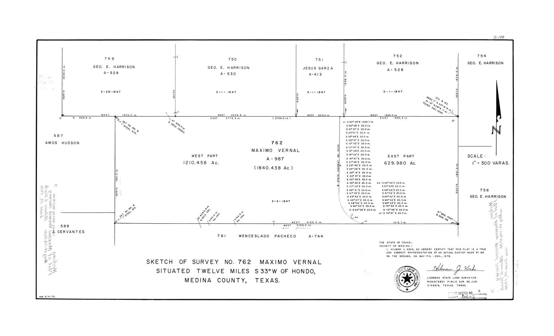
Medina County Rolled Sketch 9
Sketch of survey no. 762, Maximo Vernal situated twelve miles S 33 W of Hondo, Medina County, Texas
-
Map/Doc
6743
-
Collection
General Map Collection
-
Object Dates
1976/5/28 (Survey Date)
1976/6/14 (File Date)
-
People and Organizations
Hilmar J. Koch (Surveyor/Engineer)
-
Counties
Medina
-
Subjects
Surveying Rolled Sketch
-
Height x Width
18.8 x 31.0 inches
47.8 x 78.7 cm
-
Scale
1" = 300 varas
Part of: General Map Collection
Edwards County Working Sketch 133

Print $20.00
- Digital $50.00
Edwards County Working Sketch 133
1985
Size 29.7 x 38.9 inches
Map/Doc 69009
G.C. & S.F. Ry. Main Line, Texas, Right of Way Map, Keeler to Haslet

Print $40.00
- Digital $50.00
G.C. & S.F. Ry. Main Line, Texas, Right of Way Map, Keeler to Haslet
1916
Size 25.3 x 103.5 inches
Map/Doc 64546
Crockett County Rolled Sketch 98

Print $40.00
- Digital $50.00
Crockett County Rolled Sketch 98
2021
Size 36.5 x 48.3 inches
Map/Doc 96577
Bell County Rolled Sketch 1

Print $20.00
- Digital $50.00
Bell County Rolled Sketch 1
1954
Size 39.7 x 43.2 inches
Map/Doc 8445
Reeves County Working Sketch 4a

Print $20.00
- Digital $50.00
Reeves County Working Sketch 4a
1933
Size 26.0 x 34.6 inches
Map/Doc 63447
Tarrant County Sketch File 7

Print $6.00
- Digital $50.00
Tarrant County Sketch File 7
1856
Size 8.2 x 10.2 inches
Map/Doc 37684
Map of Anderson County

Print $40.00
- Digital $50.00
Map of Anderson County
1895
Size 48.2 x 40.2 inches
Map/Doc 4782
Hardin County Working Sketch 3

Print $3.00
- Digital $50.00
Hardin County Working Sketch 3
1906
Size 9.1 x 11.0 inches
Map/Doc 63401
[Copy from Harris County map]
![78371, [Copy from Harris County map], General Map Collection](https://historictexasmaps.com/wmedia_w700/maps/78371.tif.jpg)
Print $2.00
- Digital $50.00
[Copy from Harris County map]
Size 7.4 x 3.9 inches
Map/Doc 78371
Webb County Rolled Sketch 68

Print $43.00
- Digital $50.00
Webb County Rolled Sketch 68
1910
Size 9.6 x 15.1 inches
Map/Doc 49485
Val Verde County Working Sketch 28

Print $20.00
- Digital $50.00
Val Verde County Working Sketch 28
1937
Size 45.9 x 38.6 inches
Map/Doc 72163
Gulf Coast of the United States, Key West to Rio Grande

Print $20.00
- Digital $50.00
Gulf Coast of the United States, Key West to Rio Grande
1863
Size 27.5 x 18.3 inches
Map/Doc 72664
You may also like
Pecos County Rolled Sketch 132

Print $20.00
- Digital $50.00
Pecos County Rolled Sketch 132
Size 32.8 x 38.9 inches
Map/Doc 9728
The Republic County of Lamar. January 3, 1844

Print $20.00
The Republic County of Lamar. January 3, 1844
2020
Size 16.4 x 21.7 inches
Map/Doc 96206
Lamar County Working Sketch 10

Print $20.00
- Digital $50.00
Lamar County Working Sketch 10
1980
Size 18.6 x 15.4 inches
Map/Doc 70271
Parker County Sketch File 48

Print $20.00
- Digital $50.00
Parker County Sketch File 48
1858
Size 17.6 x 22.3 inches
Map/Doc 12152
J. De Cordova's Map of the State of Texas Compiled from the records of the General Land Office of the State

Print $20.00
- Digital $50.00
J. De Cordova's Map of the State of Texas Compiled from the records of the General Land Office of the State
Size 38.5 x 36.4 inches
Map/Doc 93984
Dimmit County Sketch File 28

Print $40.00
- Digital $50.00
Dimmit County Sketch File 28
Size 14.7 x 17.4 inches
Map/Doc 11350
[Sketch for Mineral Application 1112 - Colorado River, H. E. Chambers]
![65642, [Sketch for Mineral Application 1112 - Colorado River, H. E. Chambers], General Map Collection](https://historictexasmaps.com/wmedia_w700/maps/65642.tif.jpg)
Print $20.00
- Digital $50.00
[Sketch for Mineral Application 1112 - Colorado River, H. E. Chambers]
1918
Size 17.1 x 28.4 inches
Map/Doc 65642
[Sketch showing B. S. & F. Block 9 and vicinity]
![89786, [Sketch showing B. S. & F. Block 9 and vicinity], Twichell Survey Records](https://historictexasmaps.com/wmedia_w700/maps/89786-1.tif.jpg)
Print $20.00
- Digital $50.00
[Sketch showing B. S. & F. Block 9 and vicinity]
Size 39.0 x 47.6 inches
Map/Doc 89786
Henderson County Rolled Sketch 11

Print $20.00
- Digital $50.00
Henderson County Rolled Sketch 11
1915
Size 29.2 x 42.9 inches
Map/Doc 76149
Sketch of Surveys in Knox, Baylor, Haskell and Throckmorton Ctes

Print $40.00
- Digital $50.00
Sketch of Surveys in Knox, Baylor, Haskell and Throckmorton Ctes
1888
Size 43.3 x 58.5 inches
Map/Doc 4386
Harris County Rolled Sketch 71

Print $20.00
- Digital $50.00
Harris County Rolled Sketch 71
1944
Size 19.3 x 26.7 inches
Map/Doc 6111
[Capitol Leagues 661-729]
![91187, [Capitol Leagues 661-729], Twichell Survey Records](https://historictexasmaps.com/wmedia_w700/maps/91187-1.tif.jpg)
Print $20.00
- Digital $50.00
[Capitol Leagues 661-729]
Size 20.6 x 28.6 inches
Map/Doc 91187