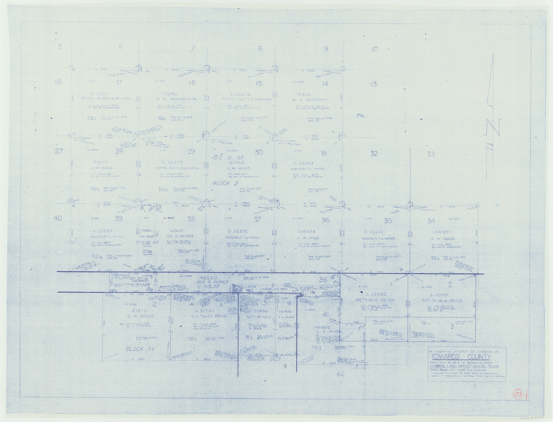
Edwards County Working Sketch 133
-
Map/Doc
69009
-
Collection
General Map Collection
-
Object Dates
5/10/1985 (Creation Date)
-
People and Organizations
C.J. Huffman (Draftsman)
-
Counties
Edwards
-
Subjects
Surveying Working Sketch
-
Height x Width
29.7 x 38.9 inches
75.4 x 98.8 cm
-
Scale
1" = 400 varas
Part of: General Map Collection
Haskell County Working Sketch 13

Print $20.00
- Digital $50.00
Haskell County Working Sketch 13
1983
Size 33.0 x 41.8 inches
Map/Doc 66071
Maps of Gulf Intracoastal Waterway, Texas - Sabine River to the Rio Grande and connecting waterways including ship channels

Print $20.00
- Digital $50.00
Maps of Gulf Intracoastal Waterway, Texas - Sabine River to the Rio Grande and connecting waterways including ship channels
1966
Size 14.5 x 22.3 inches
Map/Doc 61936
Coast Chart No. 210 Aransas Pass and Corpus Christi Bay with the coast to latitude 27° 12' Texas

Print $20.00
- Digital $50.00
Coast Chart No. 210 Aransas Pass and Corpus Christi Bay with the coast to latitude 27° 12' Texas
1913
Size 27.0 x 18.2 inches
Map/Doc 72800
[Location St. L. & S. W. R. R. Through Cherokee County]
![64044, [Location St. L. & S. W. R. R. Through Cherokee County], General Map Collection](https://historictexasmaps.com/wmedia_w700/maps/64044-1.tif.jpg)
Print $40.00
- Digital $50.00
[Location St. L. & S. W. R. R. Through Cherokee County]
Size 39.2 x 122.1 inches
Map/Doc 64044
Flight Mission No. BRA-3M, Frame 193, Jefferson County

Print $20.00
- Digital $50.00
Flight Mission No. BRA-3M, Frame 193, Jefferson County
1953
Size 18.6 x 22.3 inches
Map/Doc 85408
Galveston County NRC Article 33.136 Location Key Sheet

Print $20.00
- Digital $50.00
Galveston County NRC Article 33.136 Location Key Sheet
1994
Size 27.0 x 21.8 inches
Map/Doc 77017
Flight Mission No. DQN-5K, Frame 47, Calhoun County

Print $20.00
- Digital $50.00
Flight Mission No. DQN-5K, Frame 47, Calhoun County
1953
Size 18.5 x 22.2 inches
Map/Doc 84392
Flight Mission No. DQN-3K, Frame 11, Calhoun County

Print $20.00
- Digital $50.00
Flight Mission No. DQN-3K, Frame 11, Calhoun County
1953
Size 18.6 x 22.2 inches
Map/Doc 84343
Intracoastal Waterway - Galveston Bay to West Bay including Galveston Bay Entrance

Print $20.00
- Digital $50.00
Intracoastal Waterway - Galveston Bay to West Bay including Galveston Bay Entrance
1957
Size 27.2 x 38.6 inches
Map/Doc 69933
Baylor County Sketch File 8

Print $44.00
- Digital $50.00
Baylor County Sketch File 8
1887
Size 13.0 x 8.6 inches
Map/Doc 14137
Map and Profile No. 1 from the Red River to the Rio Grande; from explorations and surveys made under the direction of the Hon. Jefferson Davis, Secretary of War by Captain John Pope, Corps. Topl Engrs.

Print $40.00
- Digital $50.00
Map and Profile No. 1 from the Red River to the Rio Grande; from explorations and surveys made under the direction of the Hon. Jefferson Davis, Secretary of War by Captain John Pope, Corps. Topl Engrs.
Size 30.2 x 59.9 inches
Map/Doc 95176
Galveston County Sketch File 74

Print $12.00
- Digital $50.00
Galveston County Sketch File 74
2002
Size 11.3 x 8.7 inches
Map/Doc 77526
You may also like
McLaughlin Farm, Crosby County, Texas

Print $20.00
- Digital $50.00
McLaughlin Farm, Crosby County, Texas
1952
Size 14.3 x 14.1 inches
Map/Doc 92615
Val Verde County Rolled Sketch 69A

Print $40.00
- Digital $50.00
Val Verde County Rolled Sketch 69A
1942
Size 11.0 x 139.1 inches
Map/Doc 10086

[T. & G. Ry. Main Line, Texas, Right of Way Map, Center to Gary]
![64571, [T. & G. Ry. Main Line, Texas, Right of Way Map, Center to Gary], General Map Collection](https://historictexasmaps.com/wmedia_w700/maps/64571-1.tif.jpg)
Print $40.00
- Digital $50.00
[T. & G. Ry. Main Line, Texas, Right of Way Map, Center to Gary]
1917
Size 31.9 x 121.1 inches
Map/Doc 64571
Presidio County Working Sketch Graphic Index, South Part, Sheet 1 (Sketches 1 to 44)

Print $20.00
- Digital $50.00
Presidio County Working Sketch Graphic Index, South Part, Sheet 1 (Sketches 1 to 44)
1975
Size 32.3 x 38.0 inches
Map/Doc 76670
Aransas County Sketch File 5

Print $4.00
- Digital $50.00
Aransas County Sketch File 5
1850
Size 12.1 x 7.9 inches
Map/Doc 13108
Young County Working Sketch 17

Print $20.00
- Digital $50.00
Young County Working Sketch 17
1958
Size 20.7 x 28.6 inches
Map/Doc 62040
Presidio County Sketch File 31

Print $20.00
- Digital $50.00
Presidio County Sketch File 31
Size 11.4 x 20.8 inches
Map/Doc 11712
Nueces County Rolled Sketch 63

Print $20.00
- Digital $50.00
Nueces County Rolled Sketch 63
1979
Size 25.5 x 38.1 inches
Map/Doc 6909
Lake Worth Boundary

Print $20.00
- Digital $50.00
Lake Worth Boundary
Size 19.5 x 33.2 inches
Map/Doc 62211
Map of Sutton County

Print $20.00
- Digital $50.00
Map of Sutton County
1887
Size 24.5 x 29.5 inches
Map/Doc 4061
Dallas County Working Sketch 7

Print $20.00
- Digital $50.00
Dallas County Working Sketch 7
1952
Size 17.3 x 23.5 inches
Map/Doc 68573