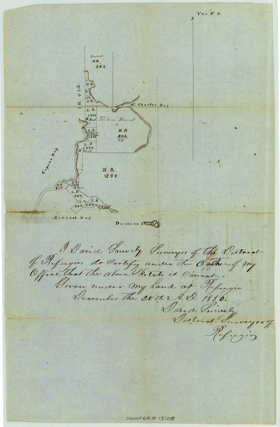
Aransas County Sketch File 5
[Peninsula of Lamar]
-
Map/Doc
13108
-
Collection
General Map Collection
-
Object Dates
1850/12/20 (Creation Date)
1851/2/20 (File Date)
-
People and Organizations
David Snively (Surveyor/Engineer)
-
Counties
Aransas
-
Subjects
Surveying Sketch File
-
Height x Width
12.1 x 7.9 inches
30.7 x 20.1 cm
-
Medium
paper, manuscript
-
Features
St. Charles Bay
Copano Bay
Aransas Bay
Dunham Island
Lamar Peninsula
Part of: General Map Collection
Outer Continental Shelf Leasing Maps (Texas Offshore Operations)

Print $20.00
- Digital $50.00
Outer Continental Shelf Leasing Maps (Texas Offshore Operations)
Size 17.7 x 14.1 inches
Map/Doc 75855
Map of Coleman County

Print $40.00
- Digital $50.00
Map of Coleman County
1897
Size 49.9 x 34.2 inches
Map/Doc 4741
Harrison County Sketch File 1

Print $26.00
- Digital $50.00
Harrison County Sketch File 1
1849
Size 8.2 x 7.7 inches
Map/Doc 26030
Webb County Rolled Sketch 41

Print $20.00
- Digital $50.00
Webb County Rolled Sketch 41
1941
Size 25.0 x 18.0 inches
Map/Doc 8196
Brewster County Working Sketch 99

Print $20.00
- Digital $50.00
Brewster County Working Sketch 99
1978
Size 19.4 x 21.9 inches
Map/Doc 67699
Eastham Farm, Texas Prison System, Houston County

Print $20.00
- Digital $50.00
Eastham Farm, Texas Prison System, Houston County
Size 17.3 x 18.4 inches
Map/Doc 62988
Map of Reeves County

Print $20.00
- Digital $50.00
Map of Reeves County
1892
Size 44.8 x 34.0 inches
Map/Doc 3983
Culberson County Working Sketch 18

Print $20.00
- Digital $50.00
Culberson County Working Sketch 18
1928
Size 42.6 x 19.7 inches
Map/Doc 68470
Red River County Working Sketch 45

Print $20.00
- Digital $50.00
Red River County Working Sketch 45
1968
Size 31.6 x 37.1 inches
Map/Doc 72028
Flight Mission No. DQN-2K, Frame 137, Calhoun County

Print $20.00
- Digital $50.00
Flight Mission No. DQN-2K, Frame 137, Calhoun County
1953
Size 18.8 x 22.5 inches
Map/Doc 84306
Runnels County Working Sketch 7

Print $20.00
- Digital $50.00
Runnels County Working Sketch 7
1929
Size 29.5 x 14.9 inches
Map/Doc 63603
Galveston County Sketch File 68

Print $62.00
- Digital $50.00
Galveston County Sketch File 68
Size 4.4 x 9.7 inches
Map/Doc 23784
You may also like

County Map of the Pan-Handle of Texas and the line of the Texas Pan-Handle Route

Print $20.00
- Digital $50.00
County Map of the Pan-Handle of Texas and the line of the Texas Pan-Handle Route
1900
Size 7.2 x 10.3 inches
Map/Doc 95888
Maverick County Sketch File 11

Print $40.00
- Digital $50.00
Maverick County Sketch File 11
1879
Size 8.3 x 8.8 inches
Map/Doc 31092
Shelby County Working Sketch 5

Print $20.00
- Digital $50.00
Shelby County Working Sketch 5
1941
Size 40.6 x 40.8 inches
Map/Doc 63858
San Antonio & Aransas Pass RR Co., Fort Bend County, Texas

Print $2.00
- Digital $50.00
San Antonio & Aransas Pass RR Co., Fort Bend County, Texas
1898
Size 11.1 x 8.7 inches
Map/Doc 64142
[Northwest Garza County around John Walker and Thomas Hughes surveys]
![90906, [Northwest Garza County around John Walker and Thomas Hughes surveys], Twichell Survey Records](https://historictexasmaps.com/wmedia_w700/maps/90906-1.tif.jpg)
Print $20.00
- Digital $50.00
[Northwest Garza County around John Walker and Thomas Hughes surveys]
1913
Size 28.3 x 14.5 inches
Map/Doc 90906
Perspective Map of the City of Laredo, Texas, the Gateway to and from Mexico

Print $20.00
Perspective Map of the City of Laredo, Texas, the Gateway to and from Mexico
1892
Size 22.1 x 34.2 inches
Map/Doc 89098
Parker County Working Sketch 6

Print $20.00
- Digital $50.00
Parker County Working Sketch 6
1923
Map/Doc 71456
Galveston Harbor, Texas

Print $20.00
- Digital $50.00
Galveston Harbor, Texas
1882
Size 15.0 x 19.5 inches
Map/Doc 97281
[St. L. S-W. Ry. Of Texas Map of Lufkin Branch in Cherokee County Texas]
![64021, [St. L. S-W. Ry. Of Texas Map of Lufkin Branch in Cherokee County Texas], General Map Collection](https://historictexasmaps.com/wmedia_w700/maps/64021.tif.jpg)
Print $40.00
- Digital $50.00
[St. L. S-W. Ry. Of Texas Map of Lufkin Branch in Cherokee County Texas]
1912
Size 23.4 x 124.3 inches
Map/Doc 64021
Jefferson County Sketch File 13

Print $6.00
- Digital $50.00
Jefferson County Sketch File 13
Size 14.9 x 9.3 inches
Map/Doc 28147
Sterling County Rolled Sketch 21

Print $20.00
- Digital $50.00
Sterling County Rolled Sketch 21
Size 29.6 x 23.8 inches
Map/Doc 7849