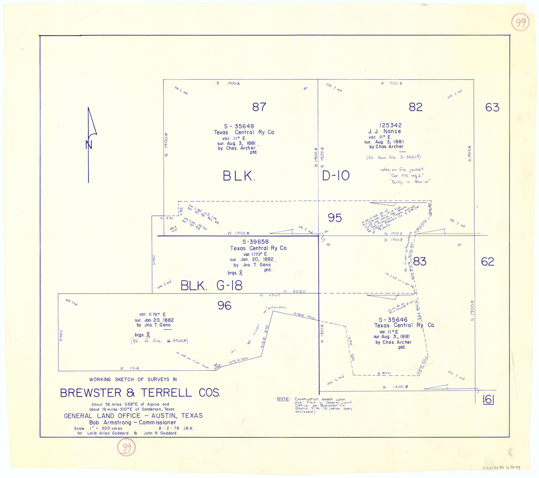
Brewster County Working Sketch 99
-
Map/Doc
67699
-
Collection
General Map Collection
-
Object Dates
8/2/1978 (Creation Date)
-
People and Organizations
Joan Kilpatrick (Draftsman)
-
Counties
Brewster
-
Subjects
Surveying Working Sketch
-
Height x Width
19.4 x 21.9 inches
49.3 x 55.6 cm
-
Scale
1" = 300 varas
Part of: General Map Collection
Potter County Sketch File 22

Print $30.00
- Digital $50.00
Potter County Sketch File 22
1962
Size 14.2 x 8.6 inches
Map/Doc 34415
Atascosa County Rolled Sketch 5B1

Print $20.00
- Digital $50.00
Atascosa County Rolled Sketch 5B1
Size 14.6 x 11.7 inches
Map/Doc 5090
Foard County Working Sketch 13

Print $40.00
- Digital $50.00
Foard County Working Sketch 13
1981
Size 44.0 x 51.2 inches
Map/Doc 69204
Hall County Sketch File B and B1

Print $14.00
- Digital $50.00
Hall County Sketch File B and B1
Size 9.2 x 8.5 inches
Map/Doc 24780
Travis County Working Sketch 61

Print $20.00
- Digital $50.00
Travis County Working Sketch 61
1995
Size 20.9 x 24.7 inches
Map/Doc 69445
Panola County

Print $20.00
- Digital $50.00
Panola County
1947
Size 40.7 x 40.3 inches
Map/Doc 73257
San Augustine County Working Sketch 2

Print $20.00
- Digital $50.00
San Augustine County Working Sketch 2
Size 28.5 x 19.1 inches
Map/Doc 63689
Zavala County Rolled Sketch 28

Print $20.00
- Digital $50.00
Zavala County Rolled Sketch 28
1956
Size 29.6 x 41.2 inches
Map/Doc 8330
Harris County Working Sketch 84

Print $20.00
- Digital $50.00
Harris County Working Sketch 84
1970
Size 36.2 x 33.7 inches
Map/Doc 65976
Pecos County Sketch File 28

Print $20.00
- Digital $50.00
Pecos County Sketch File 28
1927
Size 23.4 x 21.6 inches
Map/Doc 12168
Foard County Sketch File X

Print $20.00
- Digital $50.00
Foard County Sketch File X
1882
Size 15.8 x 17.3 inches
Map/Doc 11499
Flight Mission No. CUG-2P, Frame 29, Kleberg County

Print $20.00
- Digital $50.00
Flight Mission No. CUG-2P, Frame 29, Kleberg County
1956
Size 18.6 x 22.4 inches
Map/Doc 86194
You may also like
General Highway Map, Sterling County, Texas

Print $20.00
General Highway Map, Sterling County, Texas
1940
Size 24.9 x 18.4 inches
Map/Doc 79248
Uvalde County Rolled Sketch 18

Print $20.00
- Digital $50.00
Uvalde County Rolled Sketch 18
Size 33.2 x 24.8 inches
Map/Doc 8102
Interfaith's Official Map: The Woodlands, a real hometown for people and companies

Interfaith's Official Map: The Woodlands, a real hometown for people and companies
1997
Size 22.4 x 36.5 inches
Map/Doc 94286
San Patricio County Rolled Sketch 36

Print $40.00
- Digital $50.00
San Patricio County Rolled Sketch 36
Size 42.3 x 48.1 inches
Map/Doc 9899
Galveston County Rolled Sketch 22

Print $20.00
- Digital $50.00
Galveston County Rolled Sketch 22
1953
Size 29.6 x 40.8 inches
Map/Doc 9083
Uvalde County Boundary File 1a

Print $12.00
- Digital $50.00
Uvalde County Boundary File 1a
Size 14.5 x 8.9 inches
Map/Doc 59551
Glasscock County Sketch File 3

Print $3.00
- Digital $50.00
Glasscock County Sketch File 3
1931
Size 11.1 x 14.8 inches
Map/Doc 11560
[West half of Deaf Smith County showing School Land Leagues]
![90612, [West half of Deaf Smith County showing School Land Leagues], Twichell Survey Records](https://historictexasmaps.com/wmedia_w700/maps/90612-1.tif.jpg)
Print $20.00
- Digital $50.00
[West half of Deaf Smith County showing School Land Leagues]
Size 31.4 x 18.3 inches
Map/Doc 90612
Frio County Working Sketch 21

Print $20.00
- Digital $50.00
Frio County Working Sketch 21
1985
Size 46.1 x 43.5 inches
Map/Doc 69295
Crockett County Sketch File 99

Print $14.00
- Digital $50.00
Crockett County Sketch File 99
1925
Size 14.4 x 9.4 inches
Map/Doc 19980
Caldwell County Working Sketch 2

Print $3.00
- Digital $50.00
Caldwell County Working Sketch 2
1912
Size 11.2 x 9.1 inches
Map/Doc 67832
Presidio County Working Sketch 80

Print $20.00
- Digital $50.00
Presidio County Working Sketch 80
1967
Size 18.8 x 30.5 inches
Map/Doc 71757