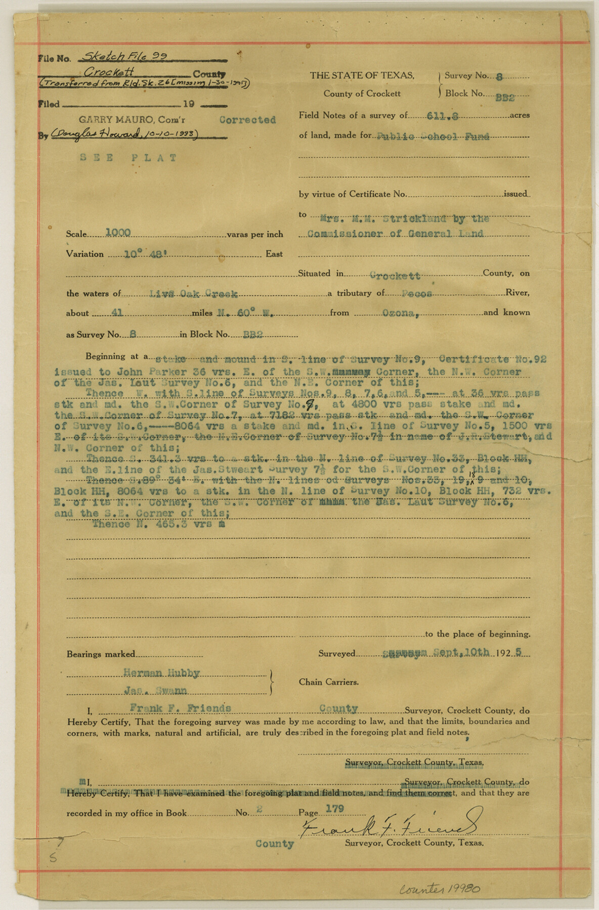
Crockett County Sketch File 99
[Unapproved, corrected field notes for surveys 8 and 12, Block BB2]
- 
                          Map/Doc19980
- 
                            CollectionGeneral Map Collection
- 
                            Object Dates1925/9/10 (Creation Date)1925/9/10 (Survey Date)
- 
                            People and OrganizationsFrank F. Friend (Surveyor/Engineer)Herman Hubby (Chainman)Jas. Swann (Chainman)
- 
                            CountiesCrockett
- 
                            SubjectsSurveying Sketch File
- 
                            Height x Width14.4 x 9.4 inches36.6 x 23.9 cm
- 
                            Mediummulti-page, multi-format
- 
                            Scale1:1000
- 
                            FeaturesLive Oak CreekPecos River
Part of: General Map Collection
            Brazos River, Brazos River Sheet 2


                                            Print $20.00                    
                                             -                         Digital $50.00                                    
                Brazos River, Brazos River Sheet 2
1926
Size 25.2 x 31.0 inches
                                Map/Doc 78265
            
            Fort Bend County State Real Property Sketch 2


                                            Print $40.00                    
                                             -                         Digital $50.00                                    
                Fort Bend County State Real Property Sketch 2
1986
Size 34.8 x 43.4 inches
                                Map/Doc 61676
            
            Haskell County Rolled Sketch 11


                                            Print $20.00                    
                                             -                         Digital $50.00                                    
                Haskell County Rolled Sketch 11
1983
Size 23.0 x 28.0 inches
                                Map/Doc 6170
            
            Martin County Sketch File 5


                                            Print $4.00                    
                                             -                         Digital $50.00                                    
                Martin County Sketch File 5
1913
Size 11.4 x 8.7 inches
                                Map/Doc 30640
            
            Austin County


                                            Print $20.00                    
                                             -                         Digital $50.00                                    
                Austin County
1943
Size 40.2 x 43.0 inches
                                Map/Doc 95422
            
            Meanders of Sulphur Fork of Red River, Red River County, Texas


                                            Print $2.00                    
                                             -                         Digital $50.00                                    
                Meanders of Sulphur Fork of Red River, Red River County, Texas
1841
Size 9.9 x 8.1 inches
                                Map/Doc 65792
            
            Walker County State Real Property Sketch 1


                                            Print $20.00                    
                                             -                         Digital $50.00                                    
                Walker County State Real Property Sketch 1
2003
Size 35.8 x 30.3 inches
                                Map/Doc 78585
            
            Maverick County Sketch File 26


                                            Print $14.00                    
                                             -                         Digital $50.00                                    
                Maverick County Sketch File 26
1955
Size 11.3 x 8.7 inches
                                Map/Doc 31153
            
            Map of the Panhandle Railway


                                            Print $40.00                    
                                             -                         Digital $50.00                                    
                Map of the Panhandle Railway
1888
Size 22.6 x 114.7 inches
                                Map/Doc 64461
            
            Flight Mission No. CLL-1N, Frame 38, Willacy County


                                            Print $20.00                    
                                             -                         Digital $50.00                                    
                Flight Mission No. CLL-1N, Frame 38, Willacy County
1954
Size 18.4 x 22.1 inches
                                Map/Doc 87019
            
            Set of new maps of Austin's Colony by G. Borden, Jr.


                                            Print $20.00                    
                                             -                         Digital $50.00                                    
                Set of new maps of Austin's Colony by G. Borden, Jr.
1833
Size 25.0 x 17.0 inches
                                Map/Doc 131
            
            Irion County Rolled Sketch 12


                                            Print $40.00                    
                                             -                         Digital $50.00                                    
                Irion County Rolled Sketch 12
1945
Size 37.5 x 51.9 inches
                                Map/Doc 75943
            You may also like
            Wise County Sketch File 46


                                            Print $20.00                    
                                             -                         Digital $50.00                                    
                Wise County Sketch File 46
Size 24.7 x 18.5 inches
                                Map/Doc 12701
            
            Hutchinson County Sketch File 29


                                            Print $20.00                    
                                             -                         Digital $50.00                                    
                Hutchinson County Sketch File 29
Size 16.7 x 20.8 inches
                                Map/Doc 11818
            
            Terrell County Rolled Sketch 38


                                            Print $20.00                    
                                             -                         Digital $50.00                                    
                Terrell County Rolled Sketch 38
Size 22.7 x 18.0 inches
                                Map/Doc 7942
            
            Gregg County Rolled Sketch 9


                                            Print $20.00                    
                                             -                         Digital $50.00                                    
                Gregg County Rolled Sketch 9
1933
Size 38.0 x 29.8 inches
                                Map/Doc 6034
            
            General Highway Map, Terry County, Texas


                                            Print $20.00                    
                                    
                General Highway Map, Terry County, Texas
1940
Size 18.5 x 24.9 inches
                                Map/Doc 79257
            
            Maps of Gulf Intracoastal Waterway, Texas - Sabine River to the Rio Grande and connecting waterways including ship channels


                                            Print $20.00                    
                                             -                         Digital $50.00                                    
                Maps of Gulf Intracoastal Waterway, Texas - Sabine River to the Rio Grande and connecting waterways including ship channels
1966
Size 14.5 x 22.4 inches
                                Map/Doc 61918
            
            Flight Mission No. CRC-3R, Frame 7, Chambers County


                                            Print $20.00                    
                                             -                         Digital $50.00                                    
                Flight Mission No. CRC-3R, Frame 7, Chambers County
1956
Size 18.6 x 22.3 inches
                                Map/Doc 84781
            
            Flight Mission No. DCL-6C, Frame 181, Kenedy County


                                            Print $20.00                    
                                             -                         Digital $50.00                                    
                Flight Mission No. DCL-6C, Frame 181, Kenedy County
1943
Size 18.5 x 22.2 inches
                                Map/Doc 85993
            
            Die Neüwen Inseln / so hinder Hispanien gegen Orient bey dem Landt Indie ligen


                                            Print $20.00                    
                                             -                         Digital $50.00                                    
                Die Neüwen Inseln / so hinder Hispanien gegen Orient bey dem Landt Indie ligen
1540
Size 12.3 x 15.6 inches
                                Map/Doc 93803
            
            Kinney County Boundary File 1a


                                            Print $73.00                    
                                             -                         Digital $50.00                                    
                Kinney County Boundary File 1a
Size 8.5 x 43.2 inches
                                Map/Doc 64946
            
            Frio County Sketch File 17


                                            Print $6.00                    
                                             -                         Digital $50.00                                    
                Frio County Sketch File 17
1955
Size 14.3 x 8.7 inches
                                Map/Doc 23152
             
                            