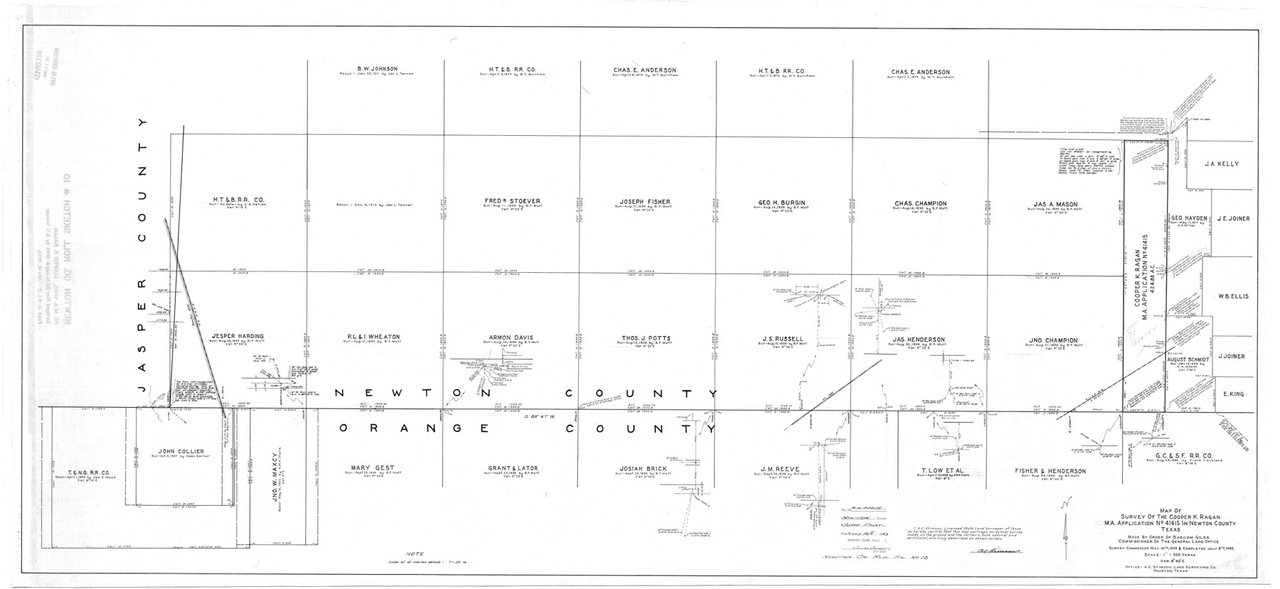
Newton County Rolled Sketch 10
Map of survey of the Cooper K. Ragan M.A. application no. 41415 in Newton County, Texas
-
Map/Doc
9575
-
Collection
General Map Collection
-
Object Dates
7/8/1949 (Creation Date)
7/16/1949 (File Date)
-
People and Organizations
A.C. Stimson (Surveyor/Engineer)
-
Counties
Newton Orange
-
Subjects
Surveying Rolled Sketch
-
Height x Width
27.4 x 59.6 inches
69.6 x 151.4 cm
-
Scale
1" = 300 varas
Part of: General Map Collection
Deaf Smith County Sketch File C

Print $28.00
- Digital $50.00
Deaf Smith County Sketch File C
1902
Size 11.5 x 8.9 inches
Map/Doc 20639
Gillespie County Sketch File 17

Print $8.00
- Digital $50.00
Gillespie County Sketch File 17
1994
Size 11.2 x 8.7 inches
Map/Doc 24157
Shelby County Rolled Sketch 9

Print $20.00
- Digital $50.00
Shelby County Rolled Sketch 9
Size 23.0 x 19.1 inches
Map/Doc 7777
Lavaca County Working Sketch 16

Print $20.00
- Digital $50.00
Lavaca County Working Sketch 16
1977
Size 25.0 x 24.9 inches
Map/Doc 70369
Map of Val Verde County

Print $40.00
- Digital $50.00
Map of Val Verde County
1898
Size 81.6 x 30.7 inches
Map/Doc 82013
Jefferson County Working Sketch 2

Print $20.00
- Digital $50.00
Jefferson County Working Sketch 2
Size 40.0 x 29.6 inches
Map/Doc 66545
Coleman County Sketch File 26a

Print $3.00
- Digital $50.00
Coleman County Sketch File 26a
Size 10.6 x 15.8 inches
Map/Doc 11120
Kimble County Working Sketch 29

Print $20.00
- Digital $50.00
Kimble County Working Sketch 29
1941
Size 24.7 x 15.3 inches
Map/Doc 70097
Jackson County Aerial Photograph Index Sheet 7

Print $20.00
- Digital $50.00
Jackson County Aerial Photograph Index Sheet 7
1956
Size 21.2 x 15.8 inches
Map/Doc 83706

Parker County Sketch File 15

Print $4.00
- Digital $50.00
Parker County Sketch File 15
1861
Size 8.3 x 8.0 inches
Map/Doc 33548
Brown County Rolled Sketch 2

Print $20.00
- Digital $50.00
Brown County Rolled Sketch 2
1984
Size 42.4 x 25.2 inches
Map/Doc 5349
You may also like
Rio Grande, Brownsville Sheet No. 2

Print $4.00
- Digital $50.00
Rio Grande, Brownsville Sheet No. 2
1924
Size 21.2 x 28.3 inches
Map/Doc 65131
San Saba County Working Sketch 1

Print $20.00
- Digital $50.00
San Saba County Working Sketch 1
1919
Size 15.3 x 15.3 inches
Map/Doc 63789
Map of League City and Subdivisions comprising the M. Muldoon 2 League Grant and part of the S.F. Austin League east of G. H. & H. R.R.

Print $20.00
- Digital $50.00
Map of League City and Subdivisions comprising the M. Muldoon 2 League Grant and part of the S.F. Austin League east of G. H. & H. R.R.
1893
Size 27.7 x 37.4 inches
Map/Doc 87500
Flight Mission No. CRC-4R, Frame 105, Chambers County

Print $20.00
- Digital $50.00
Flight Mission No. CRC-4R, Frame 105, Chambers County
1956
Size 18.8 x 22.4 inches
Map/Doc 84902
Motley County Working Sketch 10

Print $20.00
- Digital $50.00
Motley County Working Sketch 10
1984
Size 33.1 x 29.0 inches
Map/Doc 71215
Winkler County Working Sketch 15

Print $20.00
- Digital $50.00
Winkler County Working Sketch 15
1964
Size 29.2 x 30.5 inches
Map/Doc 72609
Rusk County Working Sketch 24

Print $20.00
- Digital $50.00
Rusk County Working Sketch 24
1949
Size 20.2 x 24.7 inches
Map/Doc 63660
Harris County Sketch File 20a

Print $4.00
- Digital $50.00
Harris County Sketch File 20a
Size 8.8 x 14.4 inches
Map/Doc 25371
Nueces County Rolled Sketch 89

Print $235.00
Nueces County Rolled Sketch 89
1983
Size 18.0 x 24.2 inches
Map/Doc 6991
Jack County Sketch File 4

Print $4.00
- Digital $50.00
Jack County Sketch File 4
1857
Size 9.0 x 12.7 inches
Map/Doc 27506
Flight Mission No. CUG-1P, Frame 25, Kleberg County

Print $20.00
- Digital $50.00
Flight Mission No. CUG-1P, Frame 25, Kleberg County
1956
Size 18.6 x 22.3 inches
Map/Doc 86115
Presidio County Working Sketch 64

Print $40.00
- Digital $50.00
Presidio County Working Sketch 64
1958
Size 50.2 x 37.5 inches
Map/Doc 71741