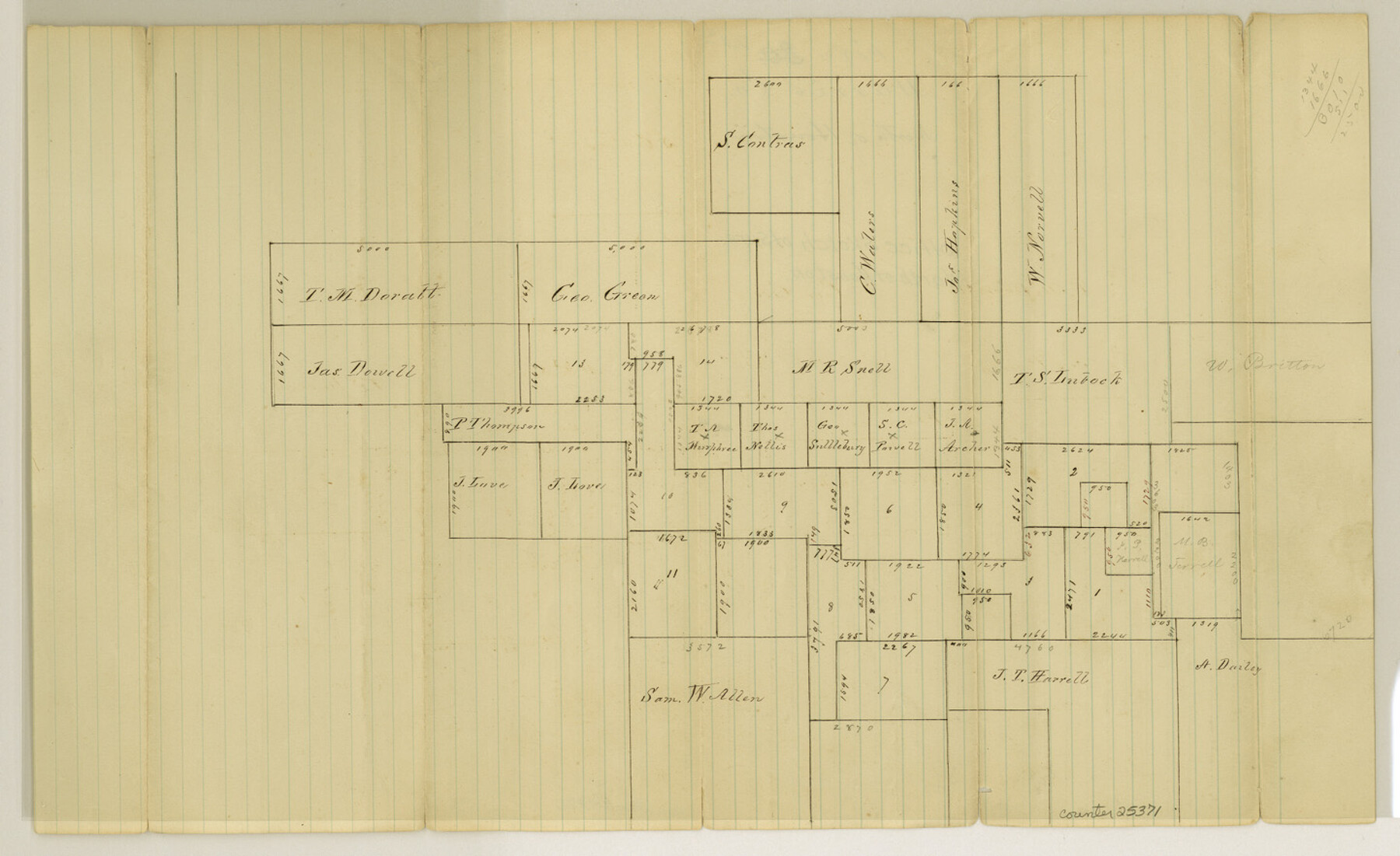
Harris County Sketch File 20a
[Office sketch of surveys north of Houston]
-
Map/Doc
25371
-
Collection
General Map Collection
-
Counties
Harris
-
Subjects
Surveying Sketch File
-
Height x Width
8.8 x 14.4 inches
22.4 x 36.6 cm
-
Medium
paper, manuscript
Part of: General Map Collection
Aransas County Rolled Sketch 15B

Print $20.00
- Digital $50.00
Aransas County Rolled Sketch 15B
Size 19.0 x 19.8 inches
Map/Doc 76066
Tom Green County Sketch File 70

Print $6.00
- Digital $50.00
Tom Green County Sketch File 70
1945
Size 11.3 x 8.9 inches
Map/Doc 38241
Uvalde County Rolled Sketch 15

Print $20.00
- Digital $50.00
Uvalde County Rolled Sketch 15
1979
Size 26.9 x 23.9 inches
Map/Doc 8099
Colorado County Working Sketch 19

Print $20.00
- Digital $50.00
Colorado County Working Sketch 19
1958
Size 25.3 x 19.1 inches
Map/Doc 68119
Flight Mission No. CGI-3N, Frame 98, Cameron County

Print $20.00
- Digital $50.00
Flight Mission No. CGI-3N, Frame 98, Cameron County
1954
Size 18.5 x 22.1 inches
Map/Doc 84578
Scurry County Rolled Sketch 3

Print $40.00
- Digital $50.00
Scurry County Rolled Sketch 3
Size 50.2 x 46.7 inches
Map/Doc 9912


Map showing survey for proposed ship channel from Brownsville to Brazos Santiago Pass

Print $20.00
- Digital $50.00
Map showing survey for proposed ship channel from Brownsville to Brazos Santiago Pass
1912
Size 18.4 x 28.8 inches
Map/Doc 72903
Nueces County Rolled Sketch 87

Print $20.00
- Digital $50.00
Nueces County Rolled Sketch 87
1983
Size 24.2 x 36.9 inches
Map/Doc 6989
Sterling County Rolled Sketch 37

Print $20.00
- Digital $50.00
Sterling County Rolled Sketch 37
Size 13.7 x 16.6 inches
Map/Doc 7862

You may also like
[Sketch for Mineral Application 20124, North Fork of Red River]
![77087, [Sketch for Mineral Application 20124, North Fork of Red River], General Map Collection](https://historictexasmaps.com/skins/default/img/placeholder/w700.png)
Print $40.00
- Digital $50.00
[Sketch for Mineral Application 20124, North Fork of Red River]
Size 50.8 x 43.5 inches
Map/Doc 77087
Map of a Part of Robertson Colony

Print $20.00
- Digital $50.00
Map of a Part of Robertson Colony
1843
Size 32.2 x 22.6 inches
Map/Doc 168
Travis County Appraisal District Plat Map 3_0404

Print $20.00
- Digital $50.00
Travis County Appraisal District Plat Map 3_0404
Size 21.5 x 26.4 inches
Map/Doc 94226
Live Oak County Boundary File 9

Print $4.00
- Digital $50.00
Live Oak County Boundary File 9
Size 12.7 x 7.8 inches
Map/Doc 56399
Flight Mission No. DCL-7C, Frame 28, Kenedy County

Print $20.00
- Digital $50.00
Flight Mission No. DCL-7C, Frame 28, Kenedy County
1943
Size 15.4 x 15.4 inches
Map/Doc 86020
Survey for J. R. Prince, Ward County, Texas

Print $20.00
- Digital $50.00
Survey for J. R. Prince, Ward County, Texas
1937
Size 47.6 x 37.7 inches
Map/Doc 89905
Briscoe County Boundary File 2

Print $4.00
- Digital $50.00
Briscoe County Boundary File 2
Size 11.2 x 8.8 inches
Map/Doc 50776
Map of the City of Galveston, Texas

Print $40.00
- Digital $50.00
Map of the City of Galveston, Texas
1883
Size 37.2 x 66.3 inches
Map/Doc 96981
Dallas County Sketch File 10

Print $4.00
- Digital $50.00
Dallas County Sketch File 10
1858
Size 12.5 x 8.2 inches
Map/Doc 20414
Cherokee County Working Sketch Graphic Index

Print $40.00
- Digital $50.00
Cherokee County Working Sketch Graphic Index
1933
Size 56.7 x 40.0 inches
Map/Doc 76492
Map of Parts of Dawson and Borden Counties

Print $20.00
- Digital $50.00
Map of Parts of Dawson and Borden Counties
Size 22.7 x 17.6 inches
Map/Doc 92034
Crane County Working Sketch 9

Print $20.00
- Digital $50.00
Crane County Working Sketch 9
1937
Size 47.6 x 42.8 inches
Map/Doc 68286