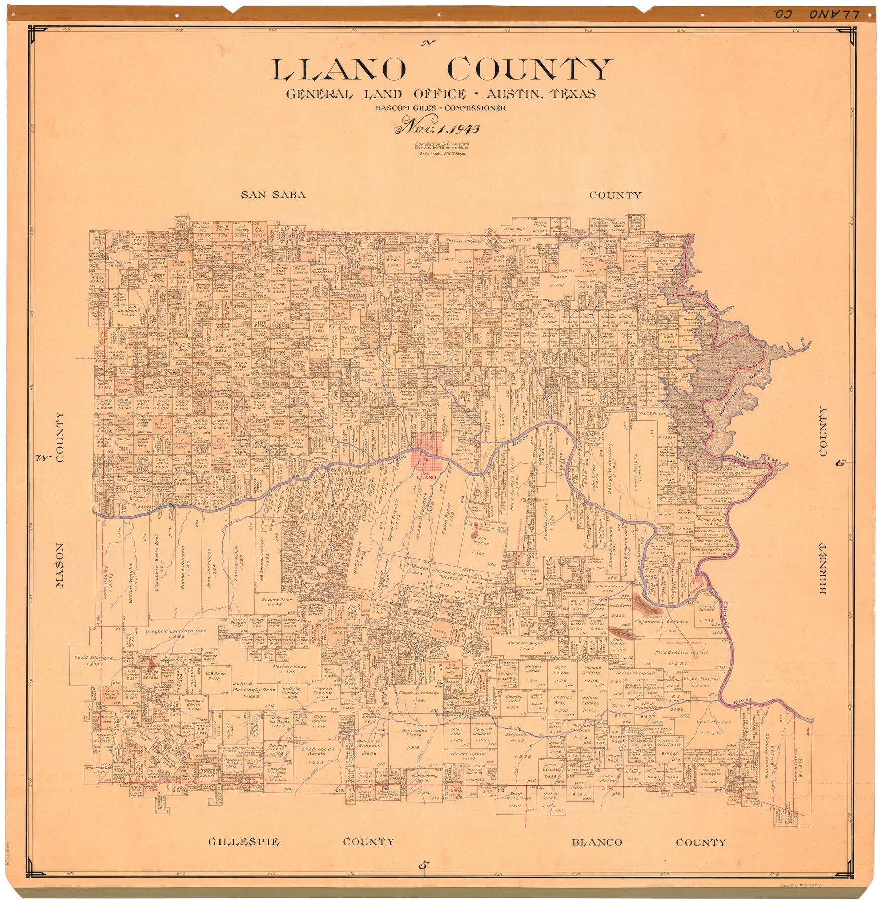
Llano County
-
Map/Doc
73224
-
Collection
General Map Collection
-
Object Dates
1943/11/1 (Creation Date)
-
People and Organizations
Texas General Land Office (Publisher)
Bascom Giles (GLO Commissioner)
Tommye Buie (Draftsman)
R.C. Wisdom (Compiler)
-
Counties
Llano
-
Subjects
County
-
Height x Width
44.1 x 42.6 inches
112.0 x 108.2 cm
-
Comments
Hand lettered.
Note on reverse side: "Compilation completed November 1, 1943. Inking completed February 7, 1944. Tracing completed March 20, 1944. Placed in official use March 21, 1944, Replaced [on sticks] by copy June 7, 1946." -
Features
Mica Creek
Kingsland
Pack Saddle Mountain
Honey Creek
Buck Spring Creek
House Mountain
Gold Mine Creek
Grape Creek
Wall Mountain
Colorado River
Hondo Creek
Lost Hollow Creek
Six Mile Creek
Sandy Creek
Legion Creek
Coal Creek
Comanche Creek
Pot Creek
Pecan Creek
Slick Rock Creek
Crab Apple Creek
Walnut Springs
Enchanted Rock
Inks Lake
Babyhead Mountain
Fall Creek
Spring Creek
Flat Fork of Llano River
Wolf Creek
Cold Creek
Buchanan Lake
Little Llano River
King Mountain
Mitchels Creek
Millers Creek
Magill Creek
H&TC
Llano River
Llano
San Fernando Creek
Flag Creek
Oatman Creek
Cat Mountain
Sharp Mountain
Hickory Creek
Elm Creek
Part of: General Map Collection
Dickens County Boundary File 4

Print $52.00
- Digital $50.00
Dickens County Boundary File 4
Size 14.2 x 8.7 inches
Map/Doc 52546
Rains County Sketch File 9

Print $20.00
- Digital $50.00
Rains County Sketch File 9
Size 14.2 x 16.3 inches
Map/Doc 34960
San Saba County Sketch File 19

Print $8.00
- Digital $50.00
San Saba County Sketch File 19
1873
Size 12.8 x 8.1 inches
Map/Doc 36466
San Luis Pass to Matagorda Bay

Print $20.00
- Digital $50.00
San Luis Pass to Matagorda Bay
1946
Size 34.7 x 46.5 inches
Map/Doc 69961
Polk County Working Sketch 36

Print $20.00
- Digital $50.00
Polk County Working Sketch 36
1963
Size 28.4 x 38.1 inches
Map/Doc 71653
Pecos County Sketch File 29

Print $20.00
- Digital $50.00
Pecos County Sketch File 29
1929
Size 26.1 x 15.8 inches
Map/Doc 12170
Anderson County Sketch File 22

Print $40.00
- Digital $50.00
Anderson County Sketch File 22
1925
Size 38.0 x 37.5 inches
Map/Doc 10315
Potter County Rolled Sketch 8

Print $20.00
- Digital $50.00
Potter County Rolled Sketch 8
1920
Size 26.3 x 30.7 inches
Map/Doc 7321
Franklin County Sketch File 2a

Print $6.00
- Digital $50.00
Franklin County Sketch File 2a
1857
Size 8.6 x 10.5 inches
Map/Doc 23012
Edwards County Working Sketch 83

Print $20.00
- Digital $50.00
Edwards County Working Sketch 83
1965
Size 29.2 x 34.3 inches
Map/Doc 68959
Terrell County Rolled Sketch 21

Print $20.00
- Digital $50.00
Terrell County Rolled Sketch 21
Size 19.1 x 27.7 inches
Map/Doc 7929
Childress County Sketch File 2a

Print $20.00
- Digital $50.00
Childress County Sketch File 2a
Size 18.3 x 34.8 inches
Map/Doc 11077
You may also like
Uvalde County Boundary File 1

Print $48.00
- Digital $50.00
Uvalde County Boundary File 1
Size 13.8 x 8.8 inches
Map/Doc 59536
Houston Ship Channel, Alexander Island to Carpenter Bayou

Print $40.00
- Digital $50.00
Houston Ship Channel, Alexander Island to Carpenter Bayou
1989
Size 35.5 x 49.4 inches
Map/Doc 69916

Blanco County Working Sketch 1

Print $20.00
- Digital $50.00
Blanco County Working Sketch 1
Size 31.1 x 17.4 inches
Map/Doc 76449
San Jacinto County Working Sketch 15

Print $20.00
- Digital $50.00
San Jacinto County Working Sketch 15
1935
Size 32.0 x 36.5 inches
Map/Doc 63728
East Half - Brown County

Print $40.00
- Digital $50.00
East Half - Brown County
1982
Size 141.3 x 36.8 inches
Map/Doc 97385
Matagorda County Sketch File 10

Print $26.00
- Digital $50.00
Matagorda County Sketch File 10
Size 8.3 x 5.2 inches
Map/Doc 30755
Greer County Sketch File 7

Print $40.00
- Digital $50.00
Greer County Sketch File 7
Size 12.8 x 17.5 inches
Map/Doc 24526
Pecos County Sketch File 51

Print $16.00
- Digital $50.00
Pecos County Sketch File 51
1881
Size 12.8 x 8.4 inches
Map/Doc 33773
Culberson County Rolled Sketch 32

Print $20.00
- Digital $50.00
Culberson County Rolled Sketch 32
1931
Size 20.2 x 36.4 inches
Map/Doc 5657
Parker County Sketch File C

Print $4.00
- Digital $50.00
Parker County Sketch File C
1857
Size 6.1 x 7.8 inches
Map/Doc 33512
Presidio County Working Sketch 68

Print $20.00
- Digital $50.00
Presidio County Working Sketch 68
1960
Size 45.8 x 33.1 inches
Map/Doc 71745