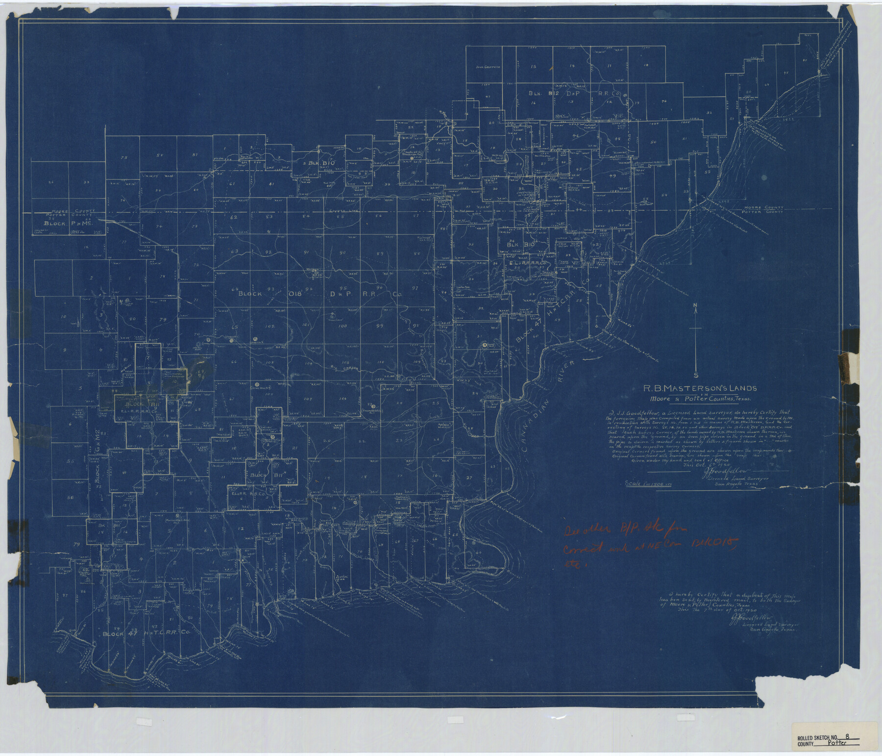
Potter County Rolled Sketch 8
R.B. Masterson's lands in Moore & Potter Counties, Texas
-
Map/Doc
7321
-
Collection
General Map Collection
-
Object Dates
1920/10/6 (Creation Date)
-
People and Organizations
J.J. Goodfellow (Surveyor/Engineer)
-
Counties
Potter Moore
-
Subjects
Surveying Rolled Sketch
-
Height x Width
26.3 x 30.7 inches
66.8 x 78.0 cm
-
Medium
blueprint/diazo
-
Scale
1" = 1500 varas
Part of: General Map Collection
McMullen County Rolled Sketch 13

Print $20.00
- Digital $50.00
McMullen County Rolled Sketch 13
1943
Size 45.8 x 29.4 inches
Map/Doc 6730
Flight Mission No. BRA-8M, Frame 71, Jefferson County

Print $20.00
- Digital $50.00
Flight Mission No. BRA-8M, Frame 71, Jefferson County
1953
Size 18.7 x 22.3 inches
Map/Doc 85591
Red River, Bois D'Arc Creek Floodway Sheet No. 1

Print $20.00
- Digital $50.00
Red River, Bois D'Arc Creek Floodway Sheet No. 1
1915
Size 28.8 x 25.9 inches
Map/Doc 69656
Trinity River, Wire Bridge Sheet/Denton Creek

Print $6.00
- Digital $50.00
Trinity River, Wire Bridge Sheet/Denton Creek
1938
Size 30.4 x 29.7 inches
Map/Doc 65244
Val Verde County Working Sketch 117

Print $20.00
- Digital $50.00
Val Verde County Working Sketch 117
1993
Size 33.8 x 37.0 inches
Map/Doc 82842
Concho County Rolled Sketch 1

Print $20.00
- Digital $50.00
Concho County Rolled Sketch 1
1945
Size 19.5 x 25.0 inches
Map/Doc 5543
Bosque County Working Sketch 33

Print $20.00
- Digital $50.00
Bosque County Working Sketch 33
2016
Size 37.0 x 25.0 inches
Map/Doc 93980
[Cameron County]
![3365, [Cameron County], General Map Collection](https://historictexasmaps.com/wmedia_w700/maps/3365-2.tif.jpg)
Print $20.00
- Digital $50.00
[Cameron County]
Size 19.2 x 21.8 inches
Map/Doc 3365
Colorado County Working Sketch 22

Print $20.00
- Digital $50.00
Colorado County Working Sketch 22
1964
Size 31.9 x 42.5 inches
Map/Doc 68122
Current Miscellaneous File 7

Print $6.00
- Digital $50.00
Current Miscellaneous File 7
1838
Size 13.8 x 8.5 inches
Map/Doc 73733
Moore County Sketch File 1

Print $20.00
- Digital $50.00
Moore County Sketch File 1
Size 28.9 x 38.6 inches
Map/Doc 10552
Chambers County Sketch File 58

Print $2.00
- Digital $50.00
Chambers County Sketch File 58
1995
Size 9.1 x 14.7 inches
Map/Doc 18108
You may also like
General Highway Map, Kimble County, Texas

Print $20.00
General Highway Map, Kimble County, Texas
1961
Size 24.6 x 18.2 inches
Map/Doc 79553
Cameron County Rolled Sketch 25

Print $20.00
- Digital $50.00
Cameron County Rolled Sketch 25
1977
Size 24.8 x 36.6 inches
Map/Doc 5798
Flight Mission No. BQR-4K, Frame 61, Brazoria County

Print $20.00
- Digital $50.00
Flight Mission No. BQR-4K, Frame 61, Brazoria County
1952
Size 18.7 x 22.5 inches
Map/Doc 83994
Flight Mission No. DQO-8K, Frame 89, Galveston County

Print $20.00
- Digital $50.00
Flight Mission No. DQO-8K, Frame 89, Galveston County
1952
Size 18.6 x 22.4 inches
Map/Doc 85191
Stephens County Sketch File 10b

Print $8.00
- Digital $50.00
Stephens County Sketch File 10b
1890
Size 8.5 x 7.8 inches
Map/Doc 37048
Presidio County Rolled Sketch 56

Print $20.00
- Digital $50.00
Presidio County Rolled Sketch 56
1915
Size 21.8 x 17.1 inches
Map/Doc 7349
Travis County Working Sketch 61

Print $20.00
- Digital $50.00
Travis County Working Sketch 61
1995
Size 20.9 x 24.7 inches
Map/Doc 69445
Travis County Rolled Sketch 15

Print $20.00
- Digital $50.00
Travis County Rolled Sketch 15
1939
Size 25.4 x 37.6 inches
Map/Doc 10011
Sterling County

Print $20.00
- Digital $50.00
Sterling County
1971
Size 42.8 x 31.1 inches
Map/Doc 77427
Colorado County Working Sketch 33

Print $20.00
- Digital $50.00
Colorado County Working Sketch 33
1988
Size 38.7 x 32.4 inches
Map/Doc 68133
Goliad County

Print $20.00
- Digital $50.00
Goliad County
1946
Size 42.8 x 45.0 inches
Map/Doc 73159
