McMullen County Rolled Sketch 13
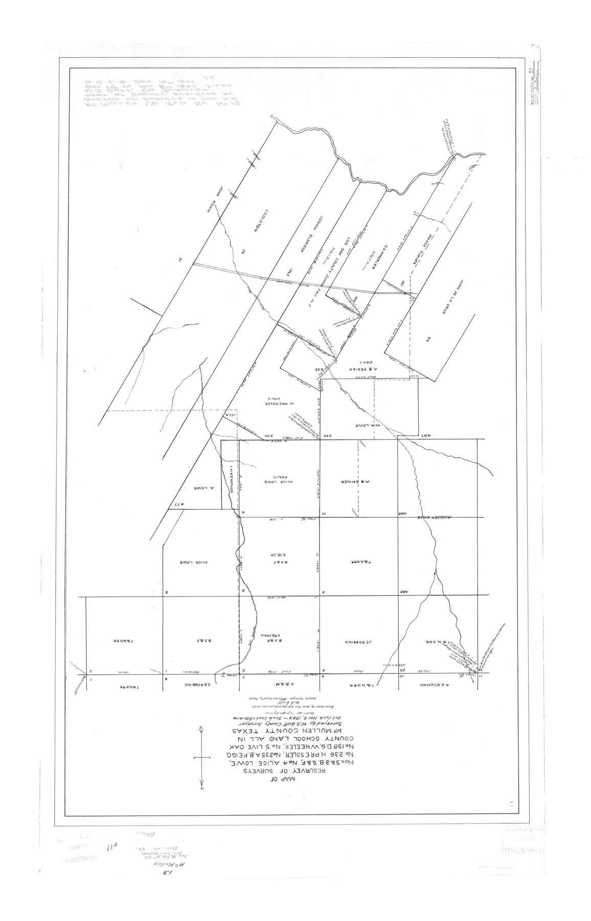
Map of resurvey of surveys nos. 5 & 3, B. S. & F., no. 4 Alice Lowe, no. 236 H. Pressler, no. 235 A.B. Peigo, no. 198 D.G. Wheeler, no. 5 Live Oak County School Land all in McMullen County, Texas
-
Map/Doc
6730
-
Collection
General Map Collection
-
Object Dates
1943/11/2 (Revision Date)
1943/12/10 (File Date)
1943/11/30 (Creation Date)
-
People and Organizations
W.S. Goff (Surveyor/Engineer)
-
Counties
McMullen
-
Subjects
Surveying Rolled Sketch
-
Height x Width
45.8 x 29.4 inches
116.3 x 74.7 cm
-
Scale
1" = 500 varas
Part of: General Map Collection
Flight Mission No. DIX-5P, Frame 148, Aransas County

Print $20.00
- Digital $50.00
Flight Mission No. DIX-5P, Frame 148, Aransas County
1956
Size 17.9 x 18.0 inches
Map/Doc 83810
Lubbock County Sketch File 13

Print $20.00
- Digital $50.00
Lubbock County Sketch File 13
1952
Size 20.4 x 14.5 inches
Map/Doc 12018
Leon County Working Sketch 17

Print $20.00
- Digital $50.00
Leon County Working Sketch 17
1959
Size 30.8 x 30.5 inches
Map/Doc 70416
Oldham County Sketch File 4

Print $20.00
- Digital $50.00
Oldham County Sketch File 4
1883
Size 13.7 x 22.5 inches
Map/Doc 12111

Palo Pinto County Working Sketch 14

Print $20.00
- Digital $50.00
Palo Pinto County Working Sketch 14
1960
Size 27.2 x 27.4 inches
Map/Doc 71397
San Augustine County Working Sketch 22

Print $20.00
- Digital $50.00
San Augustine County Working Sketch 22
1974
Size 16.1 x 29.0 inches
Map/Doc 63710
Flight Mission No. BRE-3P, Frame 35, Nueces County

Print $20.00
- Digital $50.00
Flight Mission No. BRE-3P, Frame 35, Nueces County
1956
Size 18.5 x 21.1 inches
Map/Doc 86813
Reeves County Working Sketch 28

Print $20.00
- Digital $50.00
Reeves County Working Sketch 28
1968
Size 34.4 x 42.1 inches
Map/Doc 63471
Brazoria County Working Sketch 18

Print $20.00
- Digital $50.00
Brazoria County Working Sketch 18
1949
Size 25.3 x 42.5 inches
Map/Doc 67503
Cherokee County Rolled Sketch 2

Print $20.00
- Digital $50.00
Cherokee County Rolled Sketch 2
1954
Size 44.6 x 36.0 inches
Map/Doc 8596
The Military History of Texas Map!

The Military History of Texas Map!
1996
Size 24.2 x 35.0 inches
Map/Doc 96828
You may also like
Flight Mission No. BRA-16M, Frame 171, Jefferson County

Print $20.00
- Digital $50.00
Flight Mission No. BRA-16M, Frame 171, Jefferson County
1953
Size 18.6 x 22.3 inches
Map/Doc 85769
Flight Mission No. BQR-13K, Frame 23, Brazoria County

Print $20.00
- Digital $50.00
Flight Mission No. BQR-13K, Frame 23, Brazoria County
1952
Size 18.9 x 22.4 inches
Map/Doc 84071
Martin County Rolled Sketch 10A

Print $20.00
- Digital $50.00
Martin County Rolled Sketch 10A
1994
Size 18.3 x 24.5 inches
Map/Doc 6671
General Highway Map, Pecos County, Texas

Print $20.00
General Highway Map, Pecos County, Texas
1940
Size 24.6 x 18.3 inches
Map/Doc 79217
Lipscomb County Boundary File 14b

Print $60.00
- Digital $50.00
Lipscomb County Boundary File 14b
Size 7.3 x 8.7 inches
Map/Doc 56370
Coke County Rolled Sketch 17

Print $20.00
- Digital $50.00
Coke County Rolled Sketch 17
1953
Size 36.1 x 45.2 inches
Map/Doc 8631
Brewster County Rolled Sketch 96

Print $20.00
- Digital $50.00
Brewster County Rolled Sketch 96
1951
Size 21.7 x 33.7 inches
Map/Doc 5253
Webb County Working Sketch 94

Print $20.00
- Digital $50.00
Webb County Working Sketch 94
1989
Size 23.1 x 25.6 inches
Map/Doc 72461
Nueces County Sketch File 82

Print $4.00
- Digital $50.00
Nueces County Sketch File 82
2000
Size 11.0 x 8.8 inches
Map/Doc 33165
Ellis County Sketch File 6

Print $24.00
- Digital $50.00
Ellis County Sketch File 6
Size 12.3 x 8.2 inches
Map/Doc 21836
Harrison County Working Sketch 26

Print $20.00
- Digital $50.00
Harrison County Working Sketch 26
1986
Size 38.4 x 30.0 inches
Map/Doc 66046
Bravo Deed, Instrument 24, Tract A and Tract B

Print $3.00
- Digital $50.00
Bravo Deed, Instrument 24, Tract A and Tract B
Size 9.3 x 9.4 inches
Map/Doc 91477