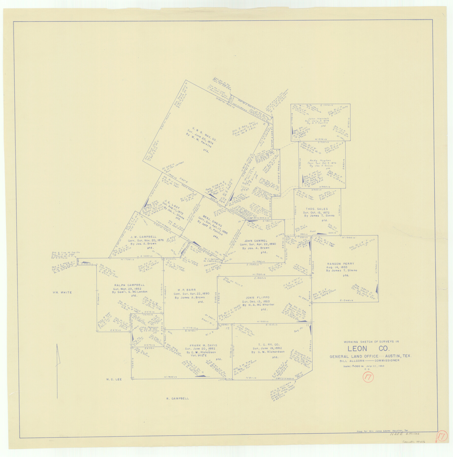
Leon County Working Sketch 17
-
Map/Doc
70416
-
Collection
General Map Collection
-
Object Dates
7/22/1959 (Creation Date)
-
People and Organizations
Roy Buckholts (Draftsman)
-
Counties
Leon
-
Subjects
Surveying Working Sketch
-
Height x Width
30.8 x 30.5 inches
78.2 x 77.5 cm
-
Scale
1" = 300 varas
Part of: General Map Collection
Current Miscellaneous File 26

Print $4.00
- Digital $50.00
Current Miscellaneous File 26
1952
Size 10.7 x 8.3 inches
Map/Doc 73907
Webb County Sketch File 49

Print $20.00
- Digital $50.00
Webb County Sketch File 49
1939
Size 20.7 x 21.5 inches
Map/Doc 12647
Jeff Davis County Working Sketch 7

Print $20.00
- Digital $50.00
Jeff Davis County Working Sketch 7
1938
Size 30.4 x 39.9 inches
Map/Doc 66502
Houston County Working Sketch 7

Print $20.00
- Digital $50.00
Houston County Working Sketch 7
1935
Size 24.7 x 36.8 inches
Map/Doc 66237
Stonewall County Sketch File 18

Print $16.00
- Digital $50.00
Stonewall County Sketch File 18
1902
Size 13.7 x 8.4 inches
Map/Doc 37276
Aransas County Rolled Sketch 3

Print $20.00
- Digital $50.00
Aransas County Rolled Sketch 3
Size 20.9 x 26.5 inches
Map/Doc 77188
Map of the Texas & Pacific Railway "Gould System" Lines and Connections

Print $20.00
- Digital $50.00
Map of the Texas & Pacific Railway "Gould System" Lines and Connections
1890
Size 18.1 x 37.0 inches
Map/Doc 94102
Liberty County Rolled Sketch B

Print $20.00
- Digital $50.00
Liberty County Rolled Sketch B
Size 34.9 x 28.2 inches
Map/Doc 9570
[Plat of Boundary Line between Comal and Hays Counties]
![65328, [Plat of Boundary Line between Comal and Hays Counties], General Map Collection](https://historictexasmaps.com/wmedia_w700/pdf_converted_jpg/qi_pdf_thumbnail_19768.jpg)
Print $20.00
- Digital $50.00
[Plat of Boundary Line between Comal and Hays Counties]
1947
Size 11.4 x 17.7 inches
Map/Doc 65328
Colorado County Working Sketch Graphic Index

Print $40.00
- Digital $50.00
Colorado County Working Sketch Graphic Index
1946
Size 52.7 x 42.4 inches
Map/Doc 76500
San Patricio County Rolled Sketch 30A

Print $20.00
- Digital $50.00
San Patricio County Rolled Sketch 30A
1941
Size 23.3 x 30.4 inches
Map/Doc 9897
Collingsworth County Sketch File 1

Print $20.00
- Digital $50.00
Collingsworth County Sketch File 1
1888
Size 23.8 x 28.9 inches
Map/Doc 11128
You may also like
Railroad Track Map, H&TCRRCo., Falls County, Texas

Print $4.00
- Digital $50.00
Railroad Track Map, H&TCRRCo., Falls County, Texas
1918
Size 11.3 x 18.5 inches
Map/Doc 62847
[West and North lines of the Panhandle]
![90576, [West and North lines of the Panhandle], Twichell Survey Records](https://historictexasmaps.com/wmedia_w700/maps/90576-1.tif.jpg)
Print $20.00
- Digital $50.00
[West and North lines of the Panhandle]
1885
Size 22.0 x 32.1 inches
Map/Doc 90576
Brooks County Working Sketch 1

Print $3.00
- Digital $50.00
Brooks County Working Sketch 1
Size 9.1 x 9.3 inches
Map/Doc 67785
Travis County Sketch File 25

Print $4.00
- Digital $50.00
Travis County Sketch File 25
1876
Size 12.7 x 8.5 inches
Map/Doc 38334
Collin County

Print $20.00
- Digital $50.00
Collin County
1975
Size 43.2 x 40.1 inches
Map/Doc 73110
Flight Mission No. BQY-4M, Frame 41, Harris County

Print $20.00
- Digital $50.00
Flight Mission No. BQY-4M, Frame 41, Harris County
1953
Size 18.6 x 22.4 inches
Map/Doc 85256
Flight Mission No. BRA-7M, Frame 10, Jefferson County

Print $20.00
- Digital $50.00
Flight Mission No. BRA-7M, Frame 10, Jefferson County
1953
Size 18.7 x 22.4 inches
Map/Doc 85461
Lavaca County Sketch File 23

Print $20.00
- Digital $50.00
Lavaca County Sketch File 23
1986
Size 14.0 x 8.6 inches
Map/Doc 29668
Presidio County Rolled Sketch 40

Print $20.00
- Digital $50.00
Presidio County Rolled Sketch 40
1907
Size 16.5 x 21.5 inches
Map/Doc 7337
Flight Mission No. CRE-2R, Frame 80, Jackson County

Print $20.00
- Digital $50.00
Flight Mission No. CRE-2R, Frame 80, Jackson County
1956
Size 18.7 x 22.3 inches
Map/Doc 85352
Bastrop County Sketch File 5

Print $4.00
- Digital $50.00
Bastrop County Sketch File 5
Size 8.1 x 10.2 inches
Map/Doc 14048
Map of the River Sabine from its mouth on the Gulf of Mexico in the sea to Logan's Ferry

Print $20.00
- Digital $50.00
Map of the River Sabine from its mouth on the Gulf of Mexico in the sea to Logan's Ferry
1842
Size 37.5 x 9.4 inches
Map/Doc 93767